Note: This document is for an older version of GRASS GIS that will be discontinued soon. You should upgrade, and read the current manual page.
NAME
d.frame - Manages display frames on the user's graphics monitor.KEYWORDS
display, graphics, monitors, frameSYNOPSIS
Flags:
- -c
- Create a new frame if doesn't exist and select
- -e
- Remove all frames, erase the screen and exit
- -p
- Print name of current frame and exit
- -a
- Print names of all frames including 'at' position and exit
- --overwrite
- Allow output files to overwrite existing files
- --help
- Print usage summary
- --verbose
- Verbose module output
- --quiet
- Quiet module output
- --ui
- Force launching GUI dialog
Parameters:
- frame=name [required]
- Frame to be selected or created (if -c flag is given)
- at=bottom,top,left,right
- Screen coordinates in percent where to place the frame (0,0 is lower-left)
- Implies only when -c or --overwrite flag is given
- Options: 0-100
Table of contents
DESCRIPTION
d.frame manages display frames on the current user's graphics monitor. Graphics are displayed in rectangular frames on whatever graphics monitor the user is currently directing GRASS display output to (defined by d.mon module). These frames are created and managed with this module.Note that GRASS frame contents are not retained when one frame covers another. You cannot shuffle frames from top to bottom and then back again. They simply define rectangular areas on the screen where subsequent drawing will occur.
NOTES
The coordinates for the at option are stated in the form top,bottom,left,right values are in percent. The upper-left corner of the graphics monitor always is at location 0,0 while the monitor's lower-right corner is always at 100,100.If the user has created multiple display frames that overlap one another, whatever the user displays in the active frame will overwrite those portions of the underlying frame where these frames overlap.
Important note: This version of d.frame works only with GRASS 7.0. Further versions of GRASS come with their own built-in d.frame module.
EXAMPLE
# start a new graphics monitor, the data will be rendered to
# /tmp/map.png image output file of size 600x540px
d.mon cairo out=/tmp/map.png width=600 height=540 --o

# set up region
g.region raster=elevation

# remove all frames and erase the current graphics monitor
d.frame -e

# create a first frame and display 'landuse96_28m' raster map including text label
d.frame -c frame=first at=0,50,0,50
d.rast landuse96_28m
d.text text='Landuse' bgcolor=220:220:220 color=black size=6

# create a second frame and display 'streams' vector map
d.frame -c frame=second at=0,50,50,100
d.vect streams color=blue
d.text text='Streams' bgcolor=220:220:220 color=black size=6

# create a third frame and display 'elevation' raster map including text label and scale
d.frame -c frame=third at=50,100,0,50
d.rast elevation
d.text text='Elevation' bgcolor=220:220:220 color=black size=6
d.barscale at=0,10 style=line bgcolor=none

# create a fourth frame and display RGB composition map including text label
d.frame -c frame=fourth at=50,100,50,100
d.rgb red=lsat7_2002_30 green=lsat7_2002_20 blue=lsat7_2002_10
d.text text='RGB true colors' bgcolor=220:220:220 color=black size=6

# release the current graphics monitor
d.mon -r
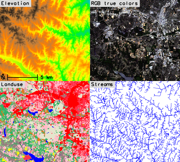
Figure: d.frame example
SEE ALSO
d.erase, d.info, d.mon, d.redrawGRASS environment variables for rendering (GRASS_RENDER_FRAME)
AUTHORS
Martin Landa, Czech Technical University in Prague, Czech Republic
Based on d.frame from GRASS 6:
James Westervelt, U.S. Army Construction Engineering Research
Laboratory
Michael Shapiro, U.S. Army Construction Engineering
Research Laboratory
SOURCE CODE
Available at: d.frame source code (history)
Latest change: Tuesday Mar 26 20:41:36 2024 in commit: 3b09b1d78f6e96ffebacac6e36f0afd91ad0c091
Note: This document is for an older version of GRASS GIS that will be discontinued soon. You should upgrade, and read the current manual page.
Main index | Display index | Topics index | Keywords index | Graphical index | Full index
© 2003-2023 GRASS Development Team, GRASS GIS 8.2.2dev Reference Manual