Note: This document is for an older version of GRASS GIS that will be discontinued soon. You should upgrade, and read the current manual page.
NAME
d.to.rast - Saves the contents of the active display monitor to a raster map.KEYWORDS
display, export, rasterSYNOPSIS
Flags:
- --overwrite
- Allow output files to overwrite existing files
- --help
- Print usage summary
- --verbose
- Verbose module output
- --quiet
- Quiet module output
- --ui
- Force launching GUI dialog
Parameters:
- output=name [required]
- Name for output raster map
Table of contents
DESCRIPTION
d.to.rast saves the content of the currently selected monitor into a raster map. The active monitor can be selected with d.mon. d.to.rast can be run from GUI Console tab, too. This module is not sensitive to computational region settings.EXAMPLE
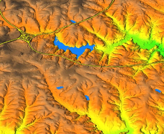
We combine different raster and vector map layers to create a composite layer which can be draped over elevation in 3D view. First, we add a couple of maps to layer manager:g.region raster=elevation d.rast map=elevation d.rast map=lakes d.vect map=roadsmajor width=4 d.vect map=roadsmajor width=2 color=yellow # create a raster map from the display d.to.rast output=composite
Then uncheck all layers except for elevation and switch to 3D view. In Data tab, set color map to the newly created composite map.

Figure: Raster map created by d.to.rast draped over digital elevation model.
SEE ALSO
d.out.file, d.erase, d.rast, d.vect, d.monAUTHOR
Anna Petrasova, NCSU OSGeoRELSOURCE CODE
Available at: d.to.rast source code (history)
Latest change: Thursday Feb 03 11:10:06 2022 in commit: 547ff44e6aecfb4c9cbf6a4717fc14e521bec0be
Note: This document is for an older version of GRASS GIS that will be discontinued soon. You should upgrade, and read the current manual page.
Main index | Display index | Topics index | Keywords index | Graphical index | Full index
© 2003-2023 GRASS Development Team, GRASS GIS 8.2.2dev Reference Manual