Note: This document is for an older version of GRASS GIS that will be discontinued soon. You should upgrade, and read the current manual page.
NAME
r.to.rast3 - Converts 2D raster map slices to one 3D raster volume map.KEYWORDS
raster, conversion, voxelSYNOPSIS
r.to.rast3
r.to.rast3 --helpr.to.rast3 [-m] input=name[,name,...] output=name [tilesize=integer] [--overwrite] [--help] [--verbose] [--quiet] [--ui]
Flags:
- -m
- Use 3D raster mask (if exists) with output map
- --overwrite
- Allow output files to overwrite existing files
- --help
- Print usage summary
- --verbose
- Verbose module output
- --quiet
- Quiet module output
- --ui
- Force launching GUI dialog
Parameters:
- input=name[,name,...] [required]
- 2D raster maps which represent the slices
- output=name [required]
- Name for output 3D raster map
- tilesize=integer
- The maximum tile size in kilo bytes. Default is 32KB.
- Default: 32
DESCRIPTION
Converts 2D raster map(s) into one raster3D map. It is important to properly set the 3D region settings, especially number or layers and depth of layers. If the 2D and 3D region settings are different, the 2D resolution will be adjusted to the 3D resolution.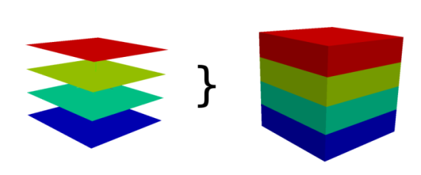
NOTES
Every 2D raster map is copied as one slice to the raster3D map. Slices are counted from bottom to the top, so the bottom slice has to be number 1.If less number of 2D raster maps are provided than defined depths, the last given 2D map is used to fill up the remaining raster3D slices to the top.
EXAMPLES
EXAMPLE 1
This example shows how to convert 6 maps into one 3D map with 6 layers.# Mapset data in Location slovakia3d g.region raster=prec_1,prec_2,prec_3,prec_4,prec_5,prec_6 -p g.region b=0 t=600 tbres=100 res3=100 -p3 r.to.rast3 input=prec_1,prec_2,prec_3,prec_4,prec_5,prec_6 output=new_3dmap
EXAMPLE 2
This example shows how to convert 3 maps into one 3D map with 6 layers.# Mapset data in Location slovakia3d g.region b=0 t=600 tbres=100 res3=100 -p3 r.to.rast3 input=prec_1,prec_2,prec_3 output=new_3dmap
SEE ALSO
g.region, r3.to.rast, r.to.rast3elevAUTHOR
Soeren GebbertSOURCE CODE
Available at: r.to.rast3 source code (history)
Latest change: Thursday Feb 03 11:10:06 2022 in commit: 547ff44e6aecfb4c9cbf6a4717fc14e521bec0be
Note: This document is for an older version of GRASS GIS that will be discontinued soon. You should upgrade, and read the current manual page.
Main index | Raster index | Topics index | Keywords index | Graphical index | Full index
© 2003-2023 GRASS Development Team, GRASS GIS 8.2.2dev Reference Manual