r.carve
Generates stream channels.
Takes vector stream data, transforms it to raster and subtracts depth from the output DEM.
r.carve [-n] raster=name vector=name output=name [points=name] [width=float] [depth=float] [--overwrite] [--verbose] [--quiet] [--qq] [--ui]
Example:
r.carve raster=name vector=name output=name
grass.tools.Tools.r_carve(raster, vector, output, points=None, width=None, depth=None, flags=None, overwrite=None, verbose=None, quiet=None, superquiet=None)
Example:
tools = Tools()
tools.r_carve(raster="name", vector="name", output="name")
This grass.tools API is experimental in version 8.5 and expected to be stable in version 8.6.
grass.script.run_command("r.carve", raster, vector, output, points=None, width=None, depth=None, flags=None, overwrite=None, verbose=None, quiet=None, superquiet=None)
Example:
gs.run_command("r.carve", raster="name", vector="name", output="name")
Parameters
raster=name [required]
Name of input raster elevation map
vector=name [required]
Name of input vector map containing stream(s)
Or data source for direct OGR access
output=name [required]
Name for output raster map
points=name
Name for output vector map for adjusted stream points
width=float
Stream width (in meters)
Default is raster cell width
depth=float
Additional stream depth (in meters)
-n
No flat areas allowed in flow direction
--overwrite
Allow output files to overwrite existing files
--help
Print usage summary
--verbose
Verbose module output
--quiet
Quiet module output
--qq
Very quiet module output
--ui
Force launching GUI dialog
raster : str | np.ndarray, required
Name of input raster elevation map
Used as: input, raster, name
vector : str, required
Name of input vector map containing stream(s)
Or data source for direct OGR access
Used as: input, vector, name
output : str | type(np.ndarray) | type(np.array) | type(gs.array.array), required
Name for output raster map
Used as: output, raster, name
points : str, optional
Name for output vector map for adjusted stream points
Used as: output, vector, name
width : float, optional
Stream width (in meters)
Default is raster cell width
depth : float, optional
Additional stream depth (in meters)
flags : str, optional
Allowed values: n
n
No flat areas allowed in flow direction
overwrite : bool, optional
Allow output files to overwrite existing files
Default: None
verbose : bool, optional
Verbose module output
Default: None
quiet : bool, optional
Quiet module output
Default: None
superquiet : bool, optional
Very quiet module output
Default: None
Returns:
result : grass.tools.support.ToolResult | np.ndarray | tuple[np.ndarray] | None
If the tool produces text as standard output, a ToolResult object will be returned. Otherwise, None will be returned. If an array type (e.g., np.ndarray) is used for one of the raster outputs, the result will be an array and will have the shape corresponding to the computational region. If an array type is used for more than one raster output, the result will be a tuple of arrays.
Raises:
grass.tools.ToolError: When the tool ended with an error.
raster : str, required
Name of input raster elevation map
Used as: input, raster, name
vector : str, required
Name of input vector map containing stream(s)
Or data source for direct OGR access
Used as: input, vector, name
output : str, required
Name for output raster map
Used as: output, raster, name
points : str, optional
Name for output vector map for adjusted stream points
Used as: output, vector, name
width : float, optional
Stream width (in meters)
Default is raster cell width
depth : float, optional
Additional stream depth (in meters)
flags : str, optional
Allowed values: n
n
No flat areas allowed in flow direction
overwrite : bool, optional
Allow output files to overwrite existing files
Default: None
verbose : bool, optional
Verbose module output
Default: None
quiet : bool, optional
Quiet module output
Default: None
superquiet : bool, optional
Very quiet module output
Default: None
DESCRIPTION
r.carve accepts vector stream data as input, transforms them to raster, and subtracts a default-depth + additional-depth from a DEM. If the given width is more than 1 cell, it will carve the stream with the given width. With the -n flag it should eliminate all flat cells within the stream, so when and if the water gets into the stream it will flow. The points option generates x,y,z for points which define the stream with the z-value of the bottom of the carved-in stream. These points can then be combined with contours to interpolate a new DEM with better representation of valleys.
NOTES
r.carve does not create a depressionless DEM because many depressions are in flat areas and not in the streams.
EXAMPLE
North Carolina sample dataset:
# set computational region
g.region raster=elev_lid792_1m -p

# digitize a ditch for the farm pond
echo "L  3 1
 638692.93595422 220198.90026383
 638737.42270627 220149.74706926
 638984.43306379 220148.19158842
 1     1" | v.in.ascii -n input=- output=ditch format=standard

# visualize original data
d.mon wx0
d.rast elev_lid792_1m
d.vect ditch

# carve
r.carve raster=elev_lid792_1m vector=ditch output=carved_dem width=3 depth=0.5

# visualize resulting carved DEM map
d.rast carved_dem

# visualize
r.relief input=elev_lid792_1m output=elev_lid792_1m_shaded
r.relief input=carved_dem output=carved_dem_shaded
d.rast elev_lid792_1m_shaded
d.erase
d.rast carved_dem_shaded

# flow accumulation
r.watershed elevation=elev_lid792_1m accumulation=elev_lid792_1m_accum
r.watershed elevation=carved_dem accumulation=carved_dem_accum
d.rast elev_lid792_1m_accum
d.erase
d.rast carved_dem_accum

# differences
r.mapcalc "accum_diff = elev_lid792_1m_accum - carved_dem_accum"
r.colors accum_diff color=differences
d.erase
d.rast accum_diff
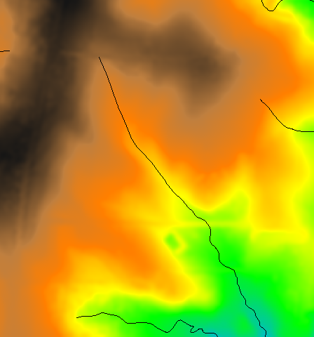
Fig: Original 1m LiDAR based DEM with vector streams map on top
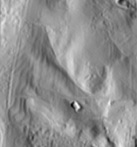
Fig: Original 1m LiDAR based DEM shown as shaded terrain
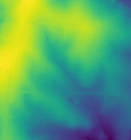
Fig: Carved 1m LiDAR based DEM
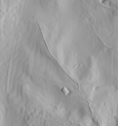
Fig: Carved 1m LiDAR based DEM shown as shaded terrain
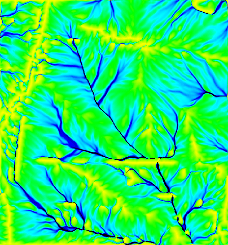
Fig: Flow accumulation in original 1m LiDAR based DEM

Fig: Flow accumulation in carved 1m LiDAR based DEM
KNOWN ISSUES
The module does not operate yet in latitude-longitude coordinate reference system.
REFERENCES
Terrain modeling and Soil Erosion Simulations for Fort Hood and Fort Polk test areas, by Helena Mitasova, Lubos Mitas, William M. Brown, Douglas M. Johnston, GMSL (Report for CERL 1999)
SEE ALSO
r.flow, r.fill.dir, r.watershed
AUTHORS
Bill Brown (GMSL)
GRASS 6 update: Brad Douglas
SOURCE CODE
Available at: r.carve source code
(history)
Latest change: Thursday Feb 13 11:55:34 2025 in commit ffc0b8c