v.clip
Extracts features of input map which overlay features of clip map.
v.clip [-dr] input=name clip=name output=name [--overwrite] [--verbose] [--quiet] [--qq] [--ui]
Example:
v.clip input=name clip=name output=name
grass.tools.Tools.v_clip(input, clip, output, flags=None, overwrite=None, verbose=None, quiet=None, superquiet=None)
Example:
tools = Tools()
tools.v_clip(input="name", clip="name", output="name")
This grass.tools API is experimental in version 8.5 and expected to be stable in version 8.6.
grass.script.run_command("v.clip", input, clip, output, flags=None, overwrite=None, verbose=None, quiet=None, superquiet=None)
Example:
gs.run_command("v.clip", input="name", clip="name", output="name")
Parameters
input=name [required]
Name of vector map to be clipped
Or data source for direct OGR access
clip=name [required]
Name of clip vector map
Or data source for direct OGR access
output=name [required]
Name for output vector map
-d
Do not dissolve clip map
-r
Clip by region
--overwrite
Allow output files to overwrite existing files
--help
Print usage summary
--verbose
Verbose module output
--quiet
Quiet module output
--qq
Very quiet module output
--ui
Force launching GUI dialog
input : str, required
Name of vector map to be clipped
Or data source for direct OGR access
Used as: input, vector, name
clip : str, required
Name of clip vector map
Or data source for direct OGR access
Used as: input, vector, name
output : str, required
Name for output vector map
Used as: output, vector, name
flags : str, optional
Allowed values: d, r
d
Do not dissolve clip map
r
Clip by region
overwrite : bool, optional
Allow output files to overwrite existing files
Default: None
verbose : bool, optional
Verbose module output
Default: None
quiet : bool, optional
Quiet module output
Default: None
superquiet : bool, optional
Very quiet module output
Default: None
Returns:
result : grass.tools.support.ToolResult | None
If the tool produces text as standard output, a ToolResult object will be returned. Otherwise, None will be returned.
Raises:
grass.tools.ToolError: When the tool ended with an error.
input : str, required
Name of vector map to be clipped
Or data source for direct OGR access
Used as: input, vector, name
clip : str, required
Name of clip vector map
Or data source for direct OGR access
Used as: input, vector, name
output : str, required
Name for output vector map
Used as: output, vector, name
flags : str, optional
Allowed values: d, r
d
Do not dissolve clip map
r
Clip by region
overwrite : bool, optional
Allow output files to overwrite existing files
Default: None
verbose : bool, optional
Verbose module output
Default: None
quiet : bool, optional
Quiet module output
Default: None
superquiet : bool, optional
Very quiet module output
Default: None
DESCRIPTION
v.clip module enables extracting those features of input vector map, which overlay features of clip map, as well as their storing in a new vector map.
In default, boundaries of clip map are dissolved before clipping. Alternatively, flag -d can be ticked to retain the boundaries of clip map. Flag -r facilitates clipping by current computational region.
It is possible to clip vector maps consisting of points, lines, areas or combinations of these. However, the current version does not fully support clipping of mixed geometry containing points. In such a case, the output map will only store clipped lines and/or areas.
NOTES
v.clip is a front-end to v.overlay, as well as v.select. Clipping of areas and/or lines can be achieved using v.overlay. Clipping of points can be performed with v.select.
EXAMPLES
Basic use
Clip railroads by counties Wake and Johnston in North Carolina (North Carolina data set).
v.extract input=boundary_county where="NAME='WAKE' OR NAME='JOHNSTON'" output=county_WAKE_JOHNSTON
v.clip input=railroads clip=county_WAKE_JOHNSTON output=railroads_WAKE_JOHNSTON
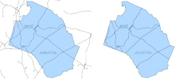
Figure: v.clip example - basic use
Retain boundaries of clip map
v.clip -d input=railroads clip=county_WAKE_JOHNSTON output=railroads_WAKE_JOHNSTON
Clip by current computational region
Clip hospitals by computational region adjusted to counties Wake and Johnston in North Carolina (North Carolina data set). It is not obligatory to enter name of clip map. In case it is stated, the clip map will be omitted.
v.extract input=boundary_county where="NAME='WAKE' OR NAME='JOHNSTON'" output=county_WAKE_JOHNSTON
v.clip -r input=hospitals output=hospitals_clip
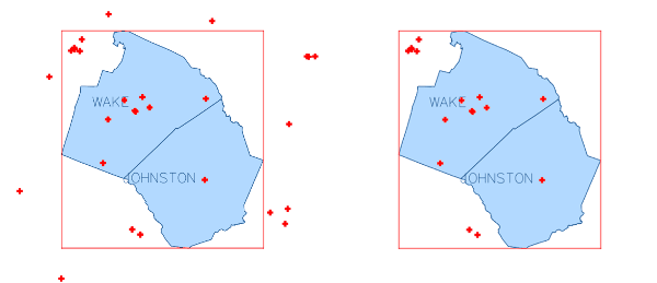
Figure: v.clip example - clip by computational region
SEE ALSO
v.overlay, v.select, v.dissolve, v.in.region
AUTHOR
Zofie Cimburova, GeoForAll Lab, Czech Technical University in Prague, Czech Republic
SOURCE CODE
Available at: v.clip source code
(history)
Latest change: Wednesday May 21 14:24:15 2025 in commit 86e588a