|
GRASS Programmer's Manual
6.5.svn(2014)-r66266
|
|
GRASS Programmer's Manual
6.5.svn(2014)-r66266
|
GRASS GIS (Geographic Resources Analysis Support System) is an open source, Free Software Geographical Information System (GIS) with raster, topological vector, image processing, and graphics production functionality that operates on various platforms through a graphical user interface (GUI) or command line interface (CLI). It is released under GNU General Public License (GPL).
This manual introduces the reader to the Geographic Resources Analysis Support System from the programming perspective. Design theory, system support libraries, system maintenance, and system enhancement are all presented. Standard GRASS 4.x conventions are still used in much of the code. This work is part of ongoing research being performed by the GRASS Development Team, an international team of programmers, GRASS module authors are cited within their module's source code and the contributed manual pages.
An up-to-date version of this Programmer's Manual is available at http://grass.osgeo.org/programming7/
© 2000-2015 GRASS Development Team
Published under GNU Free Documentation License (GFDL) http://www.fsf.org/copyleft/fdl.html
This manual comes with ABSOLUTELY NO WARRANTY. The development of GRASS software and this manual is kindly supported by the Open Source Geospatial Foundation, who provides the GRASS main infrastructure.
Main web site: http://grass.osgeo.org
Missing entries below are either not yet uploaded to SVN (need to be migrated from GRASS 5 Programmer's manual) or are simply undocumented.
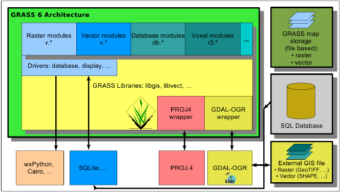
(the name refers to the directory name in lib/ in the source code)
(the name refers to the directory name in lib/ in the source code)
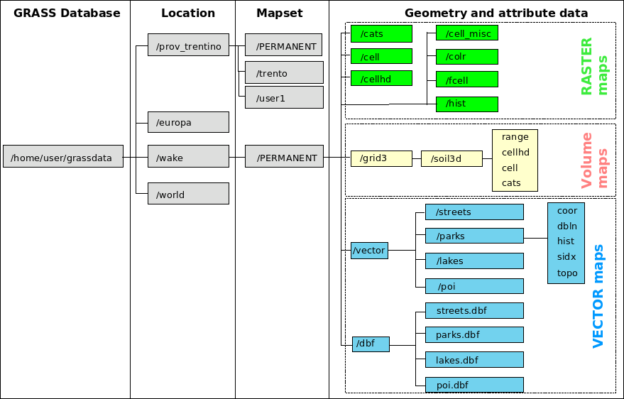
A GRASS raster map consists of several files in several subdirectories in a mapset, organized as follows:
A GRASS vector maps are stored in several separate files in a single directory. While the attributes are stored in either a DBF file, a SQLite file or in an external DBMS (PostgreSQL, MySQL, ODBC), the geometric data are saved as follows:
 1.8.5
1.8.5 
