NAME
r.recode.attr - Recode raster based on the values in one or more columns in a csv file.KEYWORDS
raster, recodeSYNOPSIS
Flags:
- -a
- Align the current region to the input raster map
- --help
- Print usage summary
- --verbose
- Verbose module output
- --quiet
- Quiet module output
- --ui
- Force launching GUI dialog
Parameters:
- input=name [required]
- Input map
- output=name [required]
- name(s) output layer(s)
- rules=name [required]
- Full path to rules file
- Name of input file
- separator=character
- Field separator
- Special characters: pipe, comma, space, tab, newline
- Default: pipe
Table of contents
DESCRIPTION
The r.recode.attr plugin let you reclass/recode a raster layer based on values specified in a csv table.The module requires the first row of the CSV file to contain column headers. The table must include at least two columns: The first column corresponds to the raster values (or a subset of them). The remaining columns contain the reclassification values, which can be either integers or floating-point numbers.For each column in the csv file (except the first one) new raster map will be created, replacing the raster values corresponding to the first column with those in the second (3rd, 4th, etc) column.
Users can define custom names for the output map(s). If only one output name is provided and the CSV file contains more than two columns, the module will automatically generate output names by appending the column names to the provided base name.
EXAMPLES
The example uses the basic North Caroline dataset. You can download it from (here). Alternatively, you can install in directly from within GRASS using the "Download sample project" option in the Data panel. Inspect the categories of the landuse raster layer.
r.category map=landuse@PERMANENT
Based on the categories of the landuse layer, create a CSV file reclass.csv. This table assigns a friction value and a suitability value to each attribute.
cat <<EOL > reclass.csv
rasterID,friction,suitability
1,0.9,0
2,0.7,0.2
3,0.6,0.4
4,0.2,0.5
5,0.1,0.9
6,1,0
7,0.8,0
EOL
Use the r.recode.attr addon to generate two new raster layers, one for friction and another for suitability. Specify a base name for the output maps. Ensure that the separator matches the delimiter used in your CSV file.
r.recode.attr input=landuse output=map rules=reclass.csv separator=comma
Note that the names of the two maps are constructed based on the provided base name 'map' + name of the name of the column. Create for both layers created above a color table.
r.colors map=map_friction color=oranges
r.colors map=map_suitability color=greens
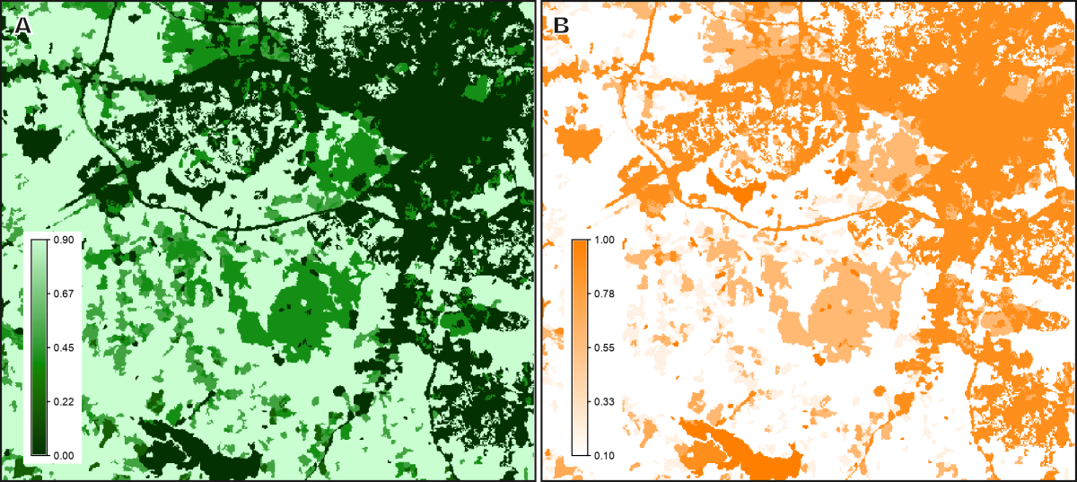
The original land use map and the derived friction and suitability maps are shown in the figure below.

Figure 1: The A) friction and B) suitability maps, based on scores assigned to each land use category of the landuse map.
SEE ALSO
r.reclass, r.recodeAUTHOR
Paulo van Breugel, https://ecodiv.earth, HAS green academy University of Applied Sciences, Innovative Biomonitoring research group, Climate-robust Landscapes research groupSOURCE CODE
Available at: r.recode.attr source code (history)
Latest change: Thursday May 29 11:23:19 2025 in commit: 701c59b932c6a12e06ba3a4135cab5955cd9047a
Main index | Raster index | Topics index | Keywords index | Graphical index | Full index
© 2003-2025 GRASS Development Team, GRASS GIS 8.4.3dev Reference Manual