r.blend
Blends color components of two raster maps by a given ratio.
r.blend [-c] first=name second=name output=basename [percent=float] [nprocs=integer] [--overwrite] [--verbose] [--quiet] [--qq] [--ui]
Example:
r.blend first=name second=name output=basename
grass.tools.Tools.r_blend(first, second, output, percent=50, nprocs=0, flags=None, overwrite=None, verbose=None, quiet=None, superquiet=None)
Example:
tools = Tools()
tools.r_blend(first="name", second="name", output="basename")
This grass.tools API is experimental in version 8.5 and expected to be stable in version 8.6.
grass.script.run_command("r.blend", first, second, output, percent=50, nprocs=0, flags=None, overwrite=None, verbose=None, quiet=None, superquiet=None)
Example:
gs.run_command("r.blend", first="name", second="name", output="basename")
Parameters
first=name [required]
Name of first raster map for blending
second=name [required]
Name of second raster map for blending
output=basename [required]
Basename for red, green and blue output raster maps
percent=float
Percentage weight of first map for color blending
Allowed values: 0-100
Default: 50
nprocs=integer
Number of threads for parallel computing
0: use OpenMP default; >0: use nprocs; <0: use MAX-nprocs
Default: 0
-c
Combine resulting R,G,B layers into single output map
--overwrite
Allow output files to overwrite existing files
--help
Print usage summary
--verbose
Verbose module output
--quiet
Quiet module output
--qq
Very quiet module output
--ui
Force launching GUI dialog
first : str | np.ndarray, required
Name of first raster map for blending
Used as: input, raster, name
second : str | np.ndarray, required
Name of second raster map for blending
Used as: input, raster, name
output : str | type(np.ndarray) | type(np.array) | type(gs.array.array), required
Basename for red, green and blue output raster maps
Used as: output, raster, basename
percent : float, optional
Percentage weight of first map for color blending
Allowed values: 0-100
Default: 50
nprocs : int, optional
Number of threads for parallel computing
0: use OpenMP default; >0: use nprocs; <0: use MAX-nprocs
Default: 0
flags : str, optional
Allowed values: c
c
Combine resulting R,G,B layers into single output map
overwrite : bool, optional
Allow output files to overwrite existing files
Default: None
verbose : bool, optional
Verbose module output
Default: None
quiet : bool, optional
Quiet module output
Default: None
superquiet : bool, optional
Very quiet module output
Default: None
Returns:
result : grass.tools.support.ToolResult | np.ndarray | tuple[np.ndarray] | None
If the tool produces text as standard output, a ToolResult object will be returned. Otherwise, None will be returned. If an array type (e.g., np.ndarray) is used for one of the raster outputs, the result will be an array and will have the shape corresponding to the computational region. If an array type is used for more than one raster output, the result will be a tuple of arrays.
Raises:
grass.tools.ToolError: When the tool ended with an error.
first : str, required
Name of first raster map for blending
Used as: input, raster, name
second : str, required
Name of second raster map for blending
Used as: input, raster, name
output : str, required
Basename for red, green and blue output raster maps
Used as: output, raster, basename
percent : float, optional
Percentage weight of first map for color blending
Allowed values: 0-100
Default: 50
nprocs : int, optional
Number of threads for parallel computing
0: use OpenMP default; >0: use nprocs; <0: use MAX-nprocs
Default: 0
flags : str, optional
Allowed values: c
c
Combine resulting R,G,B layers into single output map
overwrite : bool, optional
Allow output files to overwrite existing files
Default: None
verbose : bool, optional
Verbose module output
Default: None
quiet : bool, optional
Quiet module output
Default: None
superquiet : bool, optional
Very quiet module output
Default: None
DESCRIPTION
r.blend blends color components of 2 raster maps by a specified percentage of the first map.
EXAMPLE
Blending the aspect map with the elevation map for a shaded map (North Carolina sample dataset):
g.region raster=elevation
r.relief input=elevation output=relief zscale=10
r.blend -c first=elevation second=relief output=blend percent=75
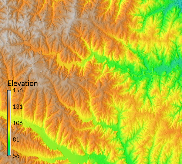
Figure: Elevation blended with shaded relief
SEE ALSO
d.shade, g.region, r.shade, r.colors, r.his, r.mapcalc, r.rgb, r.support
AUTHORS
Unknown: probably CERL
Updated to GRASS 5.7 by Michael Barton, Arizona State University
SOURCE CODE
Available at: r.blend source code
(history)
Latest change: Thursday Nov 06 23:50:00 2025 in commit f714bf8