r.thin
Thins non-null cells that denote linear features in a raster map layer.
r.thin input=name output=name [iterations=integer] [--overwrite] [--verbose] [--quiet] [--qq] [--ui]
Example:
r.thin input=name output=name
grass.tools.Tools.r_thin(input, output, iterations=200, overwrite=None, verbose=None, quiet=None, superquiet=None)
Example:
tools = Tools()
tools.r_thin(input="name", output="name")
This grass.tools API is experimental in version 8.5 and expected to be stable in version 8.6.
grass.script.run_command("r.thin", input, output, iterations=200, overwrite=None, verbose=None, quiet=None, superquiet=None)
Example:
gs.run_command("r.thin", input="name", output="name")
Parameters
input=name [required]
Name of input raster map
output=name [required]
Name for output raster map
iterations=integer
Maximal number of iterations
Default: 200
--overwrite
Allow output files to overwrite existing files
--help
Print usage summary
--verbose
Verbose module output
--quiet
Quiet module output
--qq
Very quiet module output
--ui
Force launching GUI dialog
input : str | np.ndarray, required
Name of input raster map
Used as: input, raster, name
output : str | type(np.ndarray) | type(np.array) | type(gs.array.array), required
Name for output raster map
Used as: output, raster, name
iterations : int, optional
Maximal number of iterations
Default: 200
overwrite : bool, optional
Allow output files to overwrite existing files
Default: None
verbose : bool, optional
Verbose module output
Default: None
quiet : bool, optional
Quiet module output
Default: None
superquiet : bool, optional
Very quiet module output
Default: None
Returns:
result : grass.tools.support.ToolResult | np.ndarray | tuple[np.ndarray] | None
If the tool produces text as standard output, a ToolResult object will be returned. Otherwise, None will be returned. If an array type (e.g., np.ndarray) is used for one of the raster outputs, the result will be an array and will have the shape corresponding to the computational region. If an array type is used for more than one raster output, the result will be a tuple of arrays.
Raises:
grass.tools.ToolError: When the tool ended with an error.
input : str, required
Name of input raster map
Used as: input, raster, name
output : str, required
Name for output raster map
Used as: output, raster, name
iterations : int, optional
Maximal number of iterations
Default: 200
overwrite : bool, optional
Allow output files to overwrite existing files
Default: None
verbose : bool, optional
Verbose module output
Default: None
quiet : bool, optional
Quiet module output
Default: None
superquiet : bool, optional
Very quiet module output
Default: None
DESCRIPTION
r.thin scans the named input raster map layer and thins non-NULL cells that denote linear features into linear features having a single cell width. Raster lines often need to be thinned (skeletonizing raster features) to a single pixel width before they can be transformed to vector data.
r.thin will thin only the non-NULL (no data) raster cells of the named input raster map layer within the current geographic region settings. The cell width of the thinned output raster map layer will be equal to the cell resolution of the currently set geographic region. All of the thinned linear features will have the width of a single cell.
r.thin will create a new output raster data file containing the thinned linear features. r.thin assumes that linear features are encoded with positive values on a background of NULL's in the input raster data file, hence it creates a NULL/1 output map.
NOTES
r.thin only creates raster map layers. In order to create a vector map, the user will need to run r.to.vect on the resultant raster map.
r.thin may create small spurs or "dangling lines" during the thinning process. These spurs may be removed (after creating a vector map layer) by v.clean (rmdangle tool).
This code implements the thinning algorithm described in "Analysis of Thinning Algorithms Using Mathematical Morphology" by Ben-Kwei Jang and Ronlad T. Chin in Transactions on Pattern Analysis and Machine Intelligence, vol. 12, No. 6, June 1990. The definition Jang and Chin give of the thinning process is "successive removal of outer layers of pixels from an object while retaining any pixels whose removal would alter the connectivity or shorten the legs of the skeleton."
The skeleton is finally thinned when the thinning process converges; i.e., "no further pixels can be removed without altering the connectivity or shortening the skeleton legs" (p. 541). The authors prove that the thinning process described always converges and produces one-pixel thick skeletons. The number of iterations depends on the original thickness of the object. Each iteration peels off the outside pixels from the object. Therefore, if the object is \<= n pixels thick, the algorithm should converge in \<= iterations.
EXAMPLE
To vectorize the raster map streams_derived in the North Carolina sample dataset that represents the stream network derived from the 10m resolution DEM by r.watershed, run:
g.region raster=elevation -p
# create flow accumulation map
r.watershed elevation=elevation accumulation=accum_50K thresh=50000
# extract streams from flow accumulation map
r.mapcalc "streams_from_flow = if(abs(accum_50K) > 1000, 1, null())"

# skeletonize map
r.thin streams_from_flow out=streams_thin

d.mon wx0
d.rast streams_from_flow
d.erase
d.rast streams_thin
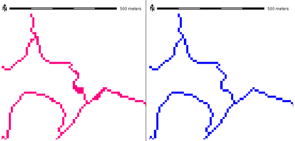
Raster feature thinning (skeletonizing)
The resulting map cabe optionally vectorized:
r.to.vect streams_thin output=streams_thin type=line
# visualize
d.rast accum_50K
d.vect streams_thin color=red width=2
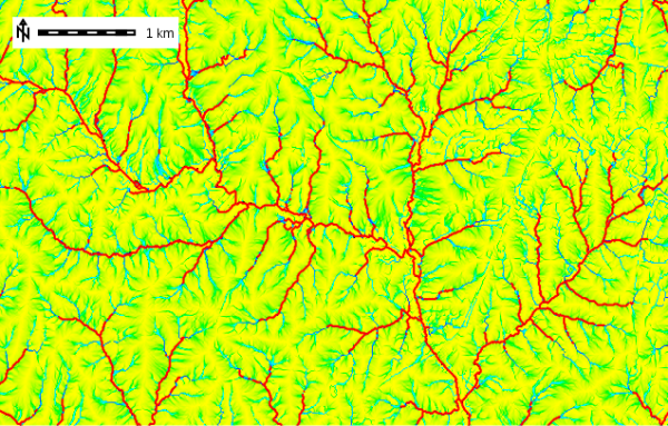
Vectorized stream network after thinning extracted from flow
accumulation map
SEE ALSO
g.region, r.to.vect, v.clean, wxGUI vector digitizer, v.build
AUTHORS
Olga Waupotitsch, U.S.Army Construction Engineering Research Laboratory
The code for finding the bounding box as well as input/output code was written by Mike Baba (DBA Systems, 1990) and Jean Ezell (USACERL, 1988).
SOURCE CODE
Available at: r.thin source code
(history)
Latest change: Saturday Oct 25 22:50:58 2025 in commit ee87f21