Note: This document is for an older version of GRASS GIS that has been discontinued. You should upgrade, and read the current manual page.
NAME
r.shaded.pca - Creates relief shades from various directions and combines them into RGB composition.The combined shades highlight terrain features which wouldn't be visible using standard shading technique.
KEYWORDS
raster, elevation, terrain, visualizationSYNOPSIS
r.shaded.pca
r.shaded.pca --helpr.shaded.pca input=string output=string [altitude=float] [nazimuths=integer] [zscale=float] [scale=float] [units=string] [shades_basename=string] [pca_shades_basename=string] [nprocs=integer] [--overwrite] [--help] [--verbose] [--quiet] [--ui]
Flags:
- --overwrite
- Allow output files to overwrite existing files
- --help
- Print usage summary
- --verbose
- Verbose module output
- --quiet
- Quiet module output
- --ui
- Force launching GUI dialog
Parameters:
- input=string [required]
- Name of the input elevation raster map
- output=string [required]
- Name for output PCA shaded relief map
- altitude=float
- Altitude of the sun in degrees above the horizon
- Options: 0-90
- Default: 30
- nazimuths=integer
- The number of azimuths (suggested values are 4, 8, 16, 32)
- Default: 8
- zscale=float
- Factor for exaggerating relief
- Default: 1
- scale=float
- Azimuth of the sun in degrees to the east of north
- Default: 1
- units=string
- Elevation units (overrides scale factor)
- Options: intl, survey
- intl: international feet
- survey: survey feet
- shades_basename=string
- Base name for output shades map
- A base of the name of shades maps for all azimuths. An underscore ('_') and a azimuth will be added to the base name. When empty, no maps will be outputted (although they need to be generated).
- pca_shades_basename=string
- Base name for output PCA shades map
- A base of the name of PCA shades maps. An underscore ('_') and a azimuth will be added to the base name. When empty, no maps will be outputted (although they need to be generated).
- nprocs=integer
- Number of r.shade.relief processes to run in parallel
- Options: 1-
- Default: 1
Table of contents
DESCRIPTION
r.shaded.pca is a tool for the generation of RGB composite of the three main components of PCA created from different hill shades (created by r.relief).Input parameters explanation
Input parameters are the same as for r.relief module except for an azimuth parameter which is replaced by nazimuths parameter (we need to specify number of different azimuths rather than one) and for an nprocs parameter which adds the possibility to run the shades creation (r.relief) in parallel. However, the speed of i.pca limits the overall speed of this module. In order to provide simple interface, it is not possible to customize principal component analyses which uses the default settings of the i.pca module.Output parameters explanation
The the standard output map is an RGB composition of first three principal components where components are assigned to red, green and blue colors in this order. If you want to create your own RGB composition, HIS composition or do another analyses you can specify the pca_shades_basename parameter. If this parameter is specified, the module outputs the PCA maps as created during the process by i.pca. Moreover, if you would like to add one of the shades to your composition, you can specify the shades_basename parameter then the module will output also the hill shade maps as created during the process by r.relief. One of the shades can be used to subtract the intensity channel in HIS composition or just as an overlay in your visualization tool.EXAMPLE
# basic example with changed vertical exaggeration
r.shaded.pca input=elevation output=elevation_pca_shaded zscale=100

# example of more complicated settings
# including output shades and principal component maps
r.shaded.pca input=elevation output=elevation_pca_shaded \
 zscale=100 altitude=15  nazimuths=16 nprocs=4 \
 shades_basename=elevation_pca_shaded_shades pca_shades_basename=elevation_pca_shaded_pcs
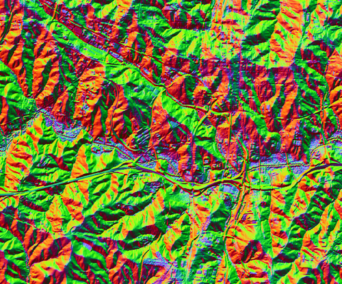
Figure: The RGB composition of first 3 PCA components (output from r.shaded.pca with default values)
SEE ALSO
r.relief, i.pca, r.local.relief, r.skyviewREFERENCES
Devereux, B. J., Amable, G. S., & Crow, P. P. (2008). Visualisation of LiDAR terrain models for archaeological feature detection. Antiquity, 82(316), 470-479.AUTHOR
Vaclav Petras, NCSU OSGeoRELSOURCE CODE
Available at: r.shaded.pca source code (history)
Latest change: Monday Jun 28 07:54:09 2021 in commit: 1cfc0af029a35a5d6c7dae5ca7204d0eb85dbc55
Main index | Raster index | Topics index | Keywords index | Graphical index | Full index
© 2003-2023 GRASS Development Team, GRASS GIS 7.8.9dev Reference Manual