Note: This document is for an older version of GRASS GIS that has been discontinued. You should upgrade, and read the current manual page.
NAME
d.legend.vect - Displays a vector legend in the active graphics frame.KEYWORDS
display, cartography, vector, legendSYNOPSIS
Flags:
- -b
- Display legend background
- --overwrite
- Allow output files to overwrite existing files
- --help
- Print usage summary
- --verbose
- Verbose module output
- --quiet
- Quiet module output
- --ui
- Force launching GUI dialog
Parameters:
- at=left,top
- Screen position of legend to be drawn (percentage, [0,0] is lower left)
- Options: 0-100
- Default: 10,40
- columns=integer
- Number of legend columns
- Default: 1
- title=string
- Legend title
- symbol_size=integer
- Symbol size
- Default: 20
- border_color=name
- Border color
- Either a standard color name, R:G:B triplet, or "none"
- Default: black
- bgcolor=name
- Background color
- Either a standard color name, R:G:B triplet, or "none"
- Default: white
- border_width=integer
- Background border width
- Default: 2
- font=string
- Font name
- fontsize=float
- Font size
- Default: 12
- Options: 1-360
- title_font=string
- Title font name
- title_fontsize=float
- Title font size
- Default: 18
- Options: 1-360
- sub_font=string
- Subtitle font name
- sub_fontsize=float
- Subtitle font size
- Default: 14
- Options: 1-360
- fontcolor=name
- Font color
- Either a standard color name or R:G:B triplet
- Default: black
- separator=character
- Field separator for input file
- Special characters: pipe, comma, space, tab, newline
- Default: pipe
- input=name
- Input legend file
- Path to legend file
- output=name
- Output csv file
- Path to output file or '-' for standard output
Table of contents
DESCRIPTION
Module d.legend.vect draws vector legend of currently displayed vector maps.Parameter at defines the screen position of upper-left legend corner. Parameter columns defines the number of legend columns. User can specify a title of the legend using parameter title. The font of the title can be changed with title_font, title_fontsize. Flag -b is used to draw background of specified color (bgcolor), border color and border width (border_color and border_width). Parameter symbol_size defines the size of line and area symbols. The size of point symbols is based on currently set symbology of vector maps using d.vect or d.vect.thematic.
Module d.vect.legend supports subtitles (see section Notes). Their font and font size can be set using parameters sub_font and sub_fontsize.
Changing legend symbols and labels
Symbols for vector areas and lines, and labels for individual vector labels can be changed in the symbology setting of each vector map in d.vect or d.vect.thematic module (in Legend tab). Use its parameters icon_area and icon_line to pick from available symbols. By using parameter legend_label of d.vect module, users can change the default label, which is the map name.Modifying the order of legend entries and omitting certain vector maps from legend
Modules d.vect and d.vect.thematic have a flag -s which removes the particular vector or thematic vector from vector legend.The order of entries is defined by the order in Layer Manager (if used in GRASS GIS GUI). If that's not desired, one can export the legend file into a text file using parameter output, change the order of entries (see section Notes for format description) and then upload the modified file with parameter input. Parameter output defines path to the file where the internal legend file will be saved to, input defines the input file which the vector legend will be based on (input file must have correct format).
NOTES
Module d.legend.vect draws vector legend based on legend file defined in shell environment variable GRASS_LEGEND_FILE. This file is automatically created and updated whenever d.vect command is used. User can create custom legend file and then use export GRASS_LEGEND_FILE=path/to/file in shell. GRASS GUI and MONITORS create the legend file automatically. By default the legend file is stored in grassdata/location/mapset/.tmp/user directory (in case of d.mon deeper in /monitor_name directory).Legend file has this format:
label|symbol_name|size|color_type|feature_color|fill_color|line_width|geometry_type|feature_countColor type can be 'lf' or 'ps'. Based on color type color columns are interpreted as line color and fill colors (lf), or primary and secondary colors (ps). Module d.vect always uses 'lf' and d.vect.thematic 'ps'. Here is an example of legend file with subtitles:
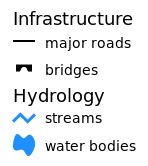
Infrastructure||||||||
major roads|legend/line|5|lf|black|200:200:200|2|line|355
bridges|extra/bridge|15|lf|black|black|1|point|10938
Hydrology||||||||
streams|legend/line_crooked|5|lf|30:144:255|200:200:200|3|line|8554
water bodies|legend/area_curved|5|lf|none|30:144:255|1|area|27764
EXAMPLES
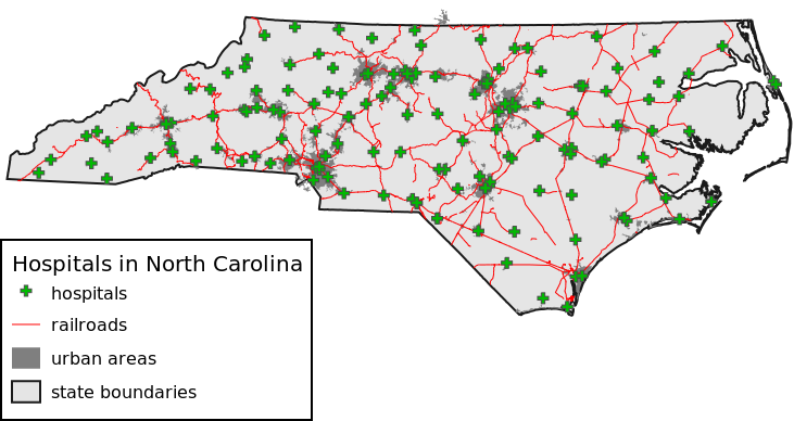
Open cairo monitor to render to file:g.region vector=nc_state d.mon cairo d.vect map=nc_state color=26:26:26 fill_color=229:229:229 width=2 legend_label="state boundaries" d.vect map=urbanarea color=none fill_color=127:127:127 width=1 legend_label="urban areas" d.vect map=railroads color=red width=1 d.vect map=hospitals color=77:77:77 fill_color=0:187:0 width=1 icon=basic/cross3 size=10 d.legend.vect -b at=2,40 title="Hospitals in North Carolina" symbol_size=26 fontsize=16 title_fontsize=20
SEE ALSO
d.vect, d.vect.thematic, d.legendCheck also Python module from AddOns: d.vect.thematic2
AUTHOR
Adam Laza, during GSoC 2016 Mentors: Anna Petrasova, Vaclav Petras, Martin LandaSOURCE CODE
Available at: d.legend.vect source code (history)
Latest change: Monday Nov 18 20:15:32 2019 in commit: 1a1d107e4f6e1b846f9841c2c6fabf015c5f720d
Main index | Display index | Topics index | Keywords index | Graphical index | Full index
© 2003-2023 GRASS Development Team, GRASS GIS 7.8.9dev Reference Manual