Note: This document is for an older version of GRASS GIS that has been discontinued. You should upgrade, and read the current manual page.
NAME
r.lake - Fills lake at given point to given level.KEYWORDS
raster, hydrology, hazard, floodSYNOPSIS
Flags:
- -n
- Use negative depth values for lake raster map
- -o
- Overwrite seed map with result (lake) map
- --overwrite
- Allow output files to overwrite existing files
- --help
- Print usage summary
- --verbose
- Verbose module output
- --quiet
- Quiet module output
- --ui
- Force launching GUI dialog
Parameters:
- elevation=name [required]
- Name of input elevation raster map
- water_level=float [required]
- Water level
- lake=name
- Name for output raster map
- coordinates=east,north
- Seed point coordinates
- Either this coordinates pair or a seed map have to be specified
- seed=name
- Input raster map with given starting point(s) (at least 1 cell > 0)
- Either this parameter or a coordinates pair have to be specified
Table of contents
DESCRIPTION
The module fills a lake to a target water level from a given start point. The user can think of it as r.grow with additional checks for elevation. The resulting raster map contains cells with values representing lake depth and NULL for all other cells beyond the lake. Lake depth is reported relative to specified water level (specified level = 0 depth).
This module uses a 3x3 moving window approach to find all cells that match three criteria and to define the lake:
- cells are below the specified elevation (i.e., water level);
- cells are connected with an initial cell (seed or coordinates pair value);
- cells are not NULL or masked.
The water level must be in DEM units.
NOTES
The seed (starting) point can be a raster map with at least one cell value greater than zero, or a seed point can be specified as an E, N coordinate pair. If the seed is specified as a coordinate pair, an additional check is done to make sure that the target water level is above the level of the DEM. When a raster map is used as a seed, however, no such checks are done. Specifying a target water level below surface represented by DEM will result in an empty map. Note: a raster lake map created in a previous run can also be used as a seed map for a new run to simulate rising water levels.The module will create a new map (lake=foo) or can be set to replace the input (seed=bar) map if the -o flag is used. The user can use -o flag to create animations of rising water level without producing a separate map for each frame. An initial seed map must be created to start the sequence, and will be overwritten during subsequent runs with resulting water levels maps (i.e., a single file serves for both input and output).
Negative output (the -n flag) is useful for visualisations in NVIZ. It equals the mapcalc's expression "negative = 0 - positive".
r.mapcalc equivalent - for GRASS hackers
This module was initially created as a script using r.mapcalc. This had some limitations - it was slow and no checks where done to find out required iteration count. The shell script code (using r.mapcalc) used in the original script is shown below:
${seedmap} = if( ${dem}, \
if( if( isnull(${seedmap}),0,${seedmap}>0), ${wlevel}-${dem}, \
 if( \
  if(isnull(${seedmap}[-1,0]),0, ${seedmap}[-1,0]>0 && ${wlevel}>${dem}) ||\
  if(isnull(${seedmap}[-1,1]),0, ${seedmap}[-1,1]>0 && ${wlevel}>${dem}) ||\
  if(isnull(${seedmap}[0,1]), 0, ${seedmap}[0,1]>0  && ${wlevel}>${dem}) ||\
  if(isnull(${seedmap}[1,1]), 0, ${seedmap}[1,1]>0  && ${wlevel}>${dem}) ||\
  if(isnull(${seedmap}[1,0]), 0, ${seedmap}[1,0]>0  && ${wlevel}>${dem}) ||\
  if(isnull(${seedmap}[1,-1]),0, ${seedmap}[1,-1]>0 && ${wlevel}>${dem}) ||\
  if(isnull(${seedmap}[0,-1]),0, ${seedmap}[0,-1]>0 && ${wlevel}>${dem}) ||\
  if(isnull(${seedmap}[-1,-1]),0, ${seedmap}[-1,-1]>0 && ${wlevel}>${dem}),\
 ${wlevel}-${dem}, null() )))
The ${seedmap} variable is replaced by seed map names, ${dem} with DEM map name, and ${wlevel} with target water level. To get single water level, this code block is called with same level numerous times (in a loop) as the lake grows by single cells during single run.
KNOWN ISSUES
- The entire map is loaded into RAM.
- A completely negative seed map will not work! At least one cell must have a value > 0. Output from r.lake -n cannot be used as input in the next run.
EXAMPLE
Example of small flooding along a street (North Carolina sample dataset):g.region raster=elev_lid792_1m -p # water accumulation next to street dam r.lake elev_lid792_1m coordinates=638759.3,220264.1 water_level=113.4 lake=flooding # draw resulting lake map over shaded terrain map r.relief input=elev_lid792_1m output=elev_lid792_1m_shade d.rast elev_lid792_1m_shade d.rast flooding d.vect streets_wake
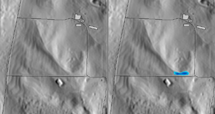
Small flooding along a street (r.lake, using Lidar 1m DEM)
SEE ALSO
r.mapcalc, r.grow, r.planeAUTHOR
Maris Nartiss (maris.nartiss gmail.com)SOURCE CODE
Available at: r.lake source code (history)
Latest change: Monday Nov 18 20:15:32 2019 in commit: 1a1d107e4f6e1b846f9841c2c6fabf015c5f720d
Main index | Raster index | Topics index | Keywords index | Graphical index | Full index
© 2003-2023 GRASS Development Team, GRASS GIS 7.8.9dev Reference Manual