Note: This document is for an older version of GRASS GIS that has been discontinued. You should upgrade, and read the current manual page.
NAME
r.water.outlet - Creates watershed basins from a drainage direction map.KEYWORDS
raster, hydrology, watershedSYNOPSIS
Flags:
- --overwrite
- Allow output files to overwrite existing files
- --help
- Print usage summary
- --verbose
- Verbose module output
- --quiet
- Quiet module output
- --ui
- Force launching GUI dialog
Parameters:
- input=name [required]
- Name of input drainage direction map
- output=name [required]
- Name for output watershed basin map
- coordinates=east,north [required]
- Coordinates of outlet point
Table of contents
DESCRIPTION
r.water.outlet generates a watershed basin from a drainage direction map and a set of coordinates representing the outlet point of watershed.Input drainage direction map indicates the "aspect" for each cell. Multiplying positive values by 45 will give the direction in degrees that the surface runoff will travel from that cell. The value -1 indicates that the cell is a depression area. Other negative values indicate that surface runoff is leaving the boundaries of the current geographic region. The absolute value of these negative cells indicates the direction of flow. This raster map is generated from r.watershed.
Output raster map values of one (1) indicate the watershed basin. Values of zero (0) are not in the watershed basin.
NOTES
In the context of this program, a watershed basin is the region upstream of an outlet point. Thus, if the user chooses an outlet point on a hill slope, the resulting map will be a thin silver of land representing the overland slope uphill of the point.EXAMPLE
A watershed in the North Carolina sample dataset region:g.region raster=elev_lid792_1m -p # the watershed outlet position should be placed on a stream (from # accumulation map): r.watershed elev_lid792_1m threshold=5000 accumulation=accum_5K drainage=draindir_5K basin=basin_5K r.water.outlet input=draindir_5K output=basin_A30 coordinates=638740.423248,220271.519225 d.mon wx0 d.rast map=accum_5K d.rast map=basin_A30 # overlay with transparency r.colors map=basin_A30 color=grey d.his h=accum_5K i=basin_A30 # report outlet size in ha r.report map=basin_A30 units=h
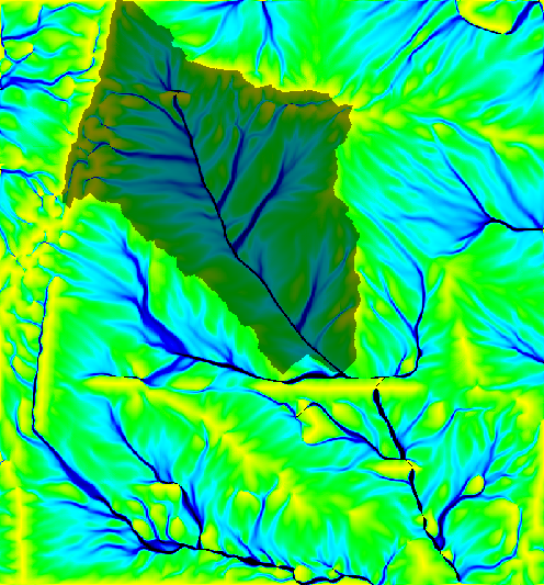
Figure: Watershed draped over flow accumulation
SEE ALSO
r.wateroutlet.lessmem (addon), d.where, r.basins.fill, r.watershed, r.topidxAUTHOR
Charles Ehlschlaeger, U.S. Army Construction Engineering Research LaboratorySOURCE CODE
Available at: r.water.outlet source code (history)
Latest change: Thursday Dec 22 12:39:52 2022 in commit: b5a70ba2c4d3115656baa764ff51a31bd5a8db19
Main index | Raster index | Topics index | Keywords index | Graphical index | Full index
© 2003-2024 GRASS Development Team, GRASS GIS 8.3.3dev Reference Manual