NAME
r.windfetch - Computes wind fetch which is the length of water over which winds blow without obstructionKEYWORDS
raster, distance, windSYNOPSIS
r.windfetch
r.windfetch --helpr.windfetch [-c] input=name [coordinates=east,north[,east,north,...]] [points=name] step=integer direction=integer minor_directions=integer minor_step=integer [output_file=name] [format=string] [--overwrite] [--help] [--verbose] [--quiet] [--ui]
Flags:
- -c
- Use compass directions (0 is North, clockwise) for input direction and output
- --overwrite
- Allow output files to overwrite existing files
- --help
- Print usage summary
- --verbose
- Verbose module output
- --quiet
- Quiet module output
- --ui
- Force launching GUI dialog
Parameters:
- input=name [required]
- Name of input land/water land use map
- Binary input where 1 is land and 0 is water
- coordinates=east,north[,east,north,...]
- Coordinates for which to compute wind fetch
- points=name
- Name of vector points map for fetch computation
- Or data source for direct OGR access
- step=integer [required]
- Angular step at which to compute wind fetch (0 is East, counterclockwise)
- Options: 0-360
- Default: 15
- direction=integer [required]
- Direction at which to start calculating fetch.
- Options: 0-359
- Default: 0
- minor_directions=integer [required]
- Number of minor directions (must be odd number).
- Fetch computed as an average of multiple minor directions around each direction.
- Options: 1-360
- Default: 5
- minor_step=integer [required]
- Angular step size between minor directions.
- Fetch computed as an average of multiple minor directions around each direction.
- Options: 1-180
- Default: 3
- output_file=name
- If not given write to standard output
- format=string
- Output format
- Options: csv, json
- Default: csv
- csv: CSV (Comma Separated Values)
- json: JSON (JavaScript Object Notation)
Table of contents
DESCRIPTION
The purpose of r.windfetch is to compute wind fetch, which is the length of water over which winds blow without obstruction. Fetch is an important feature in wave modeling for waves created by wind.Input is a binary raster map input where land is 1 and 0 is water. To compute fetch for certain point(s), user provides either the coordinates with the coordinates parameter or a points vector map with points parameter. Output is formatted with format parameter either as JSON or CSV and can be printed to a file (output_file) or to standard output.
NOTES
Wind fetch is computed for specific directions, determined by parameters direction and step. Direction angle is in degrees counterclockwise from the East. For example, fordirection=45 and step=90, r.windfetch computes fetch
for directions 45, 135, 225, and 315 (NE, NW, SW, SE).
By default wind fetch for each direction is averaged from multiple directions
around it. The number of minor directions from which the main direction is computed
is specified with parameter minor_directions. The step between the minor directions
is given in minor_step and is in degrees.
EXAMPLE
Compute wind fetch on a lake edge with default parameters:r.mapcalc "land = if (isnull(lakes), 1, 0)" r.windfetch input=land format=csv coordinates=635659,223234
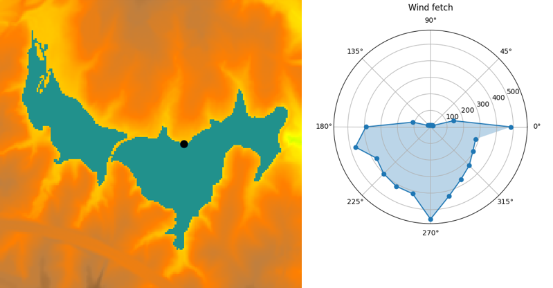
Figure: Wind fetch for a selected point, visualized in a polar plot.
SEE ALSO
r.horizon is used for computing distances.AUTHORS
Anna Petrasova, NCSU GeoForAll Lab. This addon was developed with funding from NSF Award #2322073, granted to Natrx, Inc.SOURCE CODE
Available at: r.windfetch source code (history)
Latest change: Wednesday Mar 11 08:17:30 2026 in commit: 2a14bbb9928039c7c7d0ac539d42b08ff72c88f7
Main index | Raster index | Topics index | Keywords index | Graphical index | Full index
© 2003-2026 GRASS Development Team, GRASS 8.5.1dev Reference Manual