Note: This document is for an older version of GRASS GIS that has been discontinued. You should upgrade, and read the current manual page.
NAME
i.cutlines - Creates semantically meaningful tile bordersKEYWORDS
imagery, tilingSYNOPSIS
Flags:
- --overwrite
- Allow output files to overwrite existing files
- --help
- Print usage summary
- --verbose
- Verbose module output
- --quiet
- Quiet module output
- --ui
- Force launching GUI dialog
Parameters:
- input=name [required]
- Raster map to use as input for tiling
- output=name [required]
- Name of output vector map with cutline polygons
- number_lines=integer [required]
- Number of tile border lines in each direction
- edge_detection=string [required]
- Edge detection algorithm to use
- Options: zc, canny
- Default: zc
- existing_cutlines=name[,name,...]
- Input vector maps with existing cutlines
- Or data source(s) for direct OGR access
- no_edge_friction=integer [required]
- Additional friction for non-edge pixels
- Default: 5
- lane_border_multiplier=integer [required]
- Multiplier for borders of lanes compared to non-edge pixels
- Default: 10
- min_tile_size=integer
- Minimum size of tiles in map units
- zc_threshold=float
- Sensitivity of Gaussian filter (i.zc)
- Default: 1
- zc_width=integer
- x-y extent of the Gaussian filter (i.zc)
- Default: 9
- canny_low_threshold=float
- Low treshold for edges (i.edge)
- Default: 3
- canny_high_threshold=float
- High treshold for edges (i.edge)
- Default: 10
- canny_sigma=float
- Kernel radius (i.edge)
- Default: 2
- tile_width=integer
- Width of tiles for tiled edge detection (pixels)
- tile_height=integer
- Height of tiles for tiled edge detection (pixels)
- overlap=integer
- Overlap between tiles for tiled edge detection (pixels)
- Default: 1
- processes=integer [required]
- Number of parallel processes
- Default: 1
- memory=integer [required]
- RAM memory available (in MB)
- Default: 300
Table of contents
DESCRIPTION
i.cutlines tiles the images into tiles with irregular borders that avoid cutting through meaningful objects. This allows tiling an image for parallel processing while avoiding border effects.The approach used in i.cutlines is inspired by Soares et al (2016). The module first uses an edge detection algorithm (which the user can chose with the edge_detection parameter) to identify edges in the image. It then uses r.cost and r.drain to draw lines through the image, following edges when possible and going straight when there are none.
The user can determine the number of lines desired (number_lines) in each direction and the friction associated with pixels which are not on an edge detected in the image (no_edge_friction). The higher this value, the more the module will follow the detected edges.
In order to avoid that all lines gather into one single lowest cost path, the module defines a lane for each desired line. The parameter lane_border_multiplier defines the a multiplier of the no_edge_friction value, in order to define the cost to cross that line, i.e. the lower the value, the more likely cutlines will join each other across lanes. Output is in the form of vector polygon tiles. The user can decide a minimum size defined in map units (min_tile_size). Tiles smaller than that size will be merged with the neighboring tile they share the longest border with.
The user can provide a series of auxiliary vector maps which contain existing cutlines (roads, boundaries, etc) that the module should take into account (existing_cutlines). These can be either lines or polygons. The module will transform all to potential cutlines.
For edge detection the user can chose between the i.zc module or the i.edge addon. For the former, the user can determine the zc_threshold and the zc_width parameters. For the latter, the canny_low_threshold, canny_high_threshold and canny_sigma parameters. See the manual page of the respective modules for details about these parameters which might need tuning to fit to the specific image. As these modules read the entire image into RAM, i.cutlines allows the user to run split the image into rectangular tiles and to process each tile separately. Tiles can be defined with the tile_width, tile_height and overlap parameters. If processes is higher than one, these tiles will be processed in parallel as will the r.cost calls for the two directions.
The memory parameter determines the memory used both for the r.cost runs.
NOTES
Until GRASS GIS version 7.4 included, there was a parameter name conflict between i.zc and the GridModule class in pygrass. For older GRASS GIS versions tiled edge detection is thus only possible with i.edge.EXAMPLES
Zero-crossing edge detection
Using the default i.zc edge detection without tiling, default parameters and 10 horizontal and 10 vertical cutlines, creating vector polygon output:# ortho photo subarea g.region raster=ortho_2001_t792_1m n=221070 s=219730 -p i.cutlines input=ortho_2001_t792_1m number_lines=10 output=ortho_tiles_zc
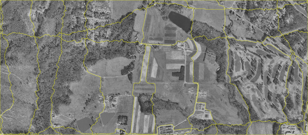
Irregular vector tiles created for the NC demo data set orthophoto (default setting)
Canny edge detection
Using the i.edge Canny edge detection with tiling and (needed) tile overlap, increased memory, two parallel processes and 10 horizontal and 10 vertical cutlines, creating vector polygon output:# ortho photo subarea g.region raster=ortho_2001_t792_1m n=221070 s=219730 -p i.cutlines input=ortho_2001_t792_1m number_lines=10 edge_detection=canny \ tile_width=500 tile_height=500 overlap=10 memory=2000 processes=2 output=ortho_tiles_canny
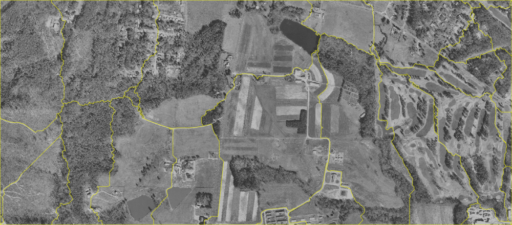
Irregular vector tiles created for the NC demo data set orthophoto (Canny edge detection)
REFERENCES
Soares, Anderson Reis, Thales Sehn Körting, and Leila Maria Garcia Fonseca. 2016. "Improvements of the Divide and Segment Method for Parallel Image Segmentation." Revista Brasileira de Cartografia 68 (6), http://www.lsie.unb.br/rbc/index.php/rbc/article/view/1602SEE ALSO
i.zc, i.edge, r.tile, v.mkgrid, i.segmentAUTHOR
Moritz LennertSOURCE CODE
Available at: i.cutlines source code (history)
Latest change: Monday Jun 28 07:54:09 2021 in commit: 1cfc0af029a35a5d6c7dae5ca7204d0eb85dbc55
Main index | Imagery index | Topics index | Keywords index | Graphical index | Full index
© 2003-2023 GRASS Development Team, GRASS GIS 7.8.9dev Reference Manual