NAME
r.in.vect - Converts an external vector layer to a raster layer using gdal.Rasterize and imports this raster layer.KEYWORDS
vector, raster, import, convert, heatmapSYNOPSIS
Flags:
- -c
- Count overlapping features
- Count overlapping features (additive mode). Sets burn value to 1, sums overlaps, and initializes raster to 0.
- -v
- Convert whole vector
- Set this flag if the whole vector layer needs to be converted. By default, only the part overlapping with the computational region is converted.
- -r
- Match region to vector bounding box
- Set region extent to match that of the bounding box of the vector layer.
- -d
- Create densified lines
- Pixels touched by lines or polygons will be included, not just those on the line render path, or whose center point is within the polygon (default: thin lines).
- -l
- Linearize curved geometries
- Convert curved geometry types (e.g., MultiSurface, CurvePolygon) to their linear equivalents before rasterizing. Required for sources like the Dutch BGT that use curve-based GML geometries.
- -a
- Print attribute table columns
- Print the names of the columns in the attribute table and exit
- --overwrite
- Allow output files to overwrite existing files
- --help
- Print usage summary
- --verbose
- Verbose module output
- --quiet
- Quiet module output
- --ui
- Force launching GUI dialog
Parameters:
- input=name [required]
- Name of input file
- layer=string
- OGR layer name
- OGR layer name, like the name of an shapefile or the name of a layer in a Geopackage (see v.in.ogr for examples)
- output=name [required]
- Name for output raster map
- attribute_column=name
- Column with raster values
- Name of attribute column that hold the values to be used as raster values (data type must be numeric)
- label_column=name
- Column with raster labels
- Name of attribute column that hold the values to be used as raster labels
- value=integer
- Raster value
- Raster value (if attribute_column is left empty)
- background=float
- Value for background pixels
- Value to assign to pixels not covered by features. If not given, these pixels will be set to NULL (nodata).
- where=sql_query
- WHERE conditions of SQL statement without 'where' keyword
- Attribute query for selecting features (without the WHERE keyword), e.g. "type = 'road' AND status = 1". Mutually exclusive with 'sql'.
- sql=string
- SQL statement
- SQL statement to select or alter features. Mutually exclusive with 'where'.
- memory=memory in MB
- Maximum memory to be used (in MB)
- Cache size for raster rows
- Default: 300
Table of contents
DESCRIPTION
r.in.vect transforms an external vector file (like GeoPackage) into a raster file and imports it into GRASS GIS. Optionally, attributes from the vector layer can be converted to raster category labels.When users have a vector file that they want to convert to a raster map, they would normally import the vector map into GRASS GIS using, e.g., v.in.ogr, and subsequently convert the resulting vector into a raster map using v.to.rast. Because of the topological vector format of GRASS GIS, importing large complex vector maps can be slow. To speed up the process, r.in.vect converts the user-defined vector file to an intermediate geoTIF file (using gdal.rasterize) and imports it into GRASS GIS.
The objects in the vector map will be assigned an user-defined value using the value parameter. Alternatively, the user can use the attribute_column to specify the name of an existing column from the vector map's attribute table. The values in that column will be used as raster values in the output raster map.
Setting the -c flag counts the number of overlapping features per pixel and assigns that count as the raster value, effectively creating a heatmap.
Optionally, only features selected with the where or sql option can be imported.
Notes
By default, r.in.vect will only affect data in areas lying inside the boundaries of the current computational region. Before running the function, users should therefore ensure that the computational region is correctly set, and that the region's resolution is at the desired level.Alternatively, use the -v flag to import the entire vector extent, ignoring the current region boundaries. By default, this produces a full-map raster without modifying the current computational region. To update the region to match the imported raster, include the -r flag. This extends the region bounds to encompass the new layer while ensuring the grid remains aligned with the existing resolution.
If the coordinate reference system (CRS) of the vector file differs from that of the mapset in which users want to import the raster, the vector file will be first reprojected using ogr2ogr.
The label_column parameter can be used to assign raster category labels. Users should check if each unique value from the category column has one corresponding label in the label column. If there are categories with more than one label, the first from the label column will be used (and a warning will be printed).
With the -d flag, all pixels touched by lines or polygons will be updated, not just those on the line render path, or which center point is within the polygon. For lines, this is similar to setting the -d flag in v.to.rast.
For simple and small vector layers, it is probably faster to import the vector layer first and converting it to a raster in GRASS.
EXAMPLE
The examples of r.in.vect use vector maps from the North Carolina sample data set.Example 1
First, export a vector layer as a GeoPackage.# Export the geology vector map as Geopackage v.out.ogr input=geology@PERMANENT output=geology.gpkg format=GPKG
Import the geology.gpkg as raster. Raster cells overlapping with the vector features will be assigned a value of 1, and the other raster cells null. If you have RAM to spare, increase the memory to speed up the import.
# Set the region
g.region -a vector=geology res=500

# Import the GeoPackage
r.in.vect input=geology.gpkg \
output=geology_rast \
value=1 \
memory=2000
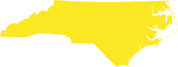
Figure 1: The geology vector file was converted to, and imported as a raster into GRASS GIS, using the default settings.
If the GeoPackage file (or any other data source) has multiple layers, users need to specify which layer to use with the layer parameter. Otherwise, the first layer will be selected.
Example 2
Import the geology.gpkg as raster. Specify the column holding the values to use as raster values and the column holding the labels for the raster values.# Import the layer r.in.vect input=geology.gpkg \ output=geology_rast2 \ attribute_column=GEOL250_ \ label_column=GEO_NAME memory=2000 # Assign random colors r.colors map=geology_rast2 color=random
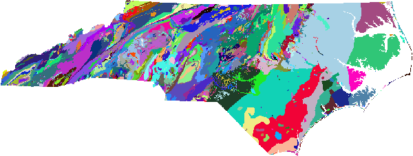
Figure 2: The geology vector file converted to raster and imported into GRASS GIS using the values from the vector attribute column GEOL250_ as raster values.
Example 3
First, set the resolution to 1 meter. Next, export the busroute6 vector map as GeoPackage, and import it as a raster. Use the -v flag to ensure the extent of the raster matches that of the vector (by default, the bounding box of the raster map will match that of the current computational region).# Set the resolution to 1 m g.region -a res=1 # Export the busrout6 vector layer v.out.ogr input=busroute6@PERMANENT \ type=line \ output=busroute6.gpkg \ format=GPKG # Import it as raster layer, using the extent of the vector layer r.in.vect -v input=busroute6.gpkg \ output=busroute6_1 \ value=1 \ memory=2000
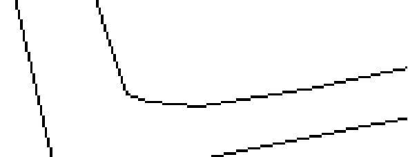
Figure 3: The busroute6 vector file converted to raster and imported into GRASS GIS using the extent of the vector map.
Example 4
The same as above, but using the -d flag to create densified lines.# Import vector as a raster map, using the extent of the vector r.in.vect -v -d \ input=busroute6.gpkg \ output=busroute6_2 \ value=1 \ memory=2000
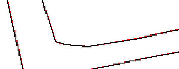
Figure 4: Rasterize the busroute 6 vector map using the -d flag to create densified lines by adding extra cells (shown in red). This avoids gaps or lines that consist of cells that are only diagonally connected.
SEE ALSO
v.to.rastAUTHORS
Paulo van Breugel | HAS green academy, University of Applied Sciences | Climate-robust Landscapes research group | Innovative Bio-Monitoring research group | Contact: Ecodiv.earthSOURCE CODE
Available at: r.in.vect source code (history)
Latest change: Monday Jun 22 12:53:40 2026 in commit: 425b037ef1e9b0e72e14a0db5b7ba685ba4c21a4
Main index | Raster index | Topics index | Keywords index | Graphical index | Full index
© 2003-2026 GRASS Development Team, GRASS 8.5.1dev Reference Manual