html_state Struct Reference
#include <htmlmap.h>
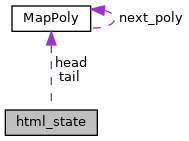
Collaboration diagram for html_state:

Data Fields | |
| char * | last_text |
| int | last_text_len |
| int | type |
| FILE * | output |
| struct MapPoly * | head |
| struct MapPoly ** | tail |
| int | MAX_POINTS |
| int | BBOX_MINIMUM |
| int | MINIMUM_DIST |
Detailed Description
Field Documentation
◆ BBOX_MINIMUM
◆ head
◆ last_text
◆ last_text_len
◆ MAX_POINTS
◆ MINIMUM_DIST
| int html_state::MINIMUM_DIST |
Definition at line 34 of file htmlmap.h.
Referenced by html_polygon().
◆ output
◆ tail
◆ type
The documentation for this struct was generated from the following file: