GRASS Database
A GRASS Database is simply a set of directories and files with a certain structure with which GRASS works efficiently. A project is a directory with data related to one geographic location or a project. All data within one project has the same coordinate reference system. A project contains mapsets and each mapset contains data related to a specific task, user or a smaller project. Within each project, a mandatory PERMANENT mapset exists which can contain commonly used data within one GRASS project such as base maps. The PERMANENT mapset also contains metadata related to the project such as the coordinate reference system. When GRASS is started, it connects to a database, project and mapset specified by the user.
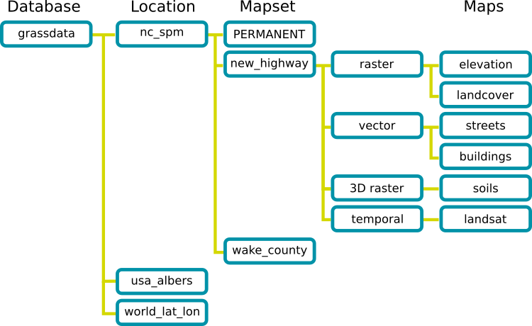
Fig. 1: GRASS Database structure as visible to the user
GRASS Database Directory
All data for GRASS must be in a GRASS Database which is a
directory (visible on the disk) containing subdirectories which are
GRASS projects. A user can have one or more Databases on the disk.
Typically users have one directory called grassdata in their home
directory. In multi-user environment users often have a grassdata
directory mounted as a network directory (network file system). For
teams, a centralized GRASS DATABASE would be defined in a shared network
file system (e.g. NFS).
GRASS Databases can be safely copied or moved as any other directories. Don't be confused with (relational) databases which are used in GRASS to hold attribute data and might be part of the GRASS Database. From the user's point of view, GRASS Database with all its data in it is similar to, e.g. PostGIS database, as it stores all information in a specific format and is accessible by specific tools. GRASS Database is often called GISDBASE or DATABASE.
GRASS Projects
A project is further organized into mapsets which are subdirectories of the project directory. All data in one project has the same coordinate reference system (projection, datum). Each project contains a mapset called PERMANENT. Typically, a project contains all data related to one real-world project or a geographic area (geographic location or region). Alternatively, a project can simply contain data in a given coordinate reference system.
GRASS projects can be safely copied or moved as any other directories. Compressed projects are usually what GRASS users exchange between each other when they want to share a lot of data. For example, GRASS sample data are provided as projects.
Note that a GRASS project used to be called location and this name has not been completely removed from code and documentation yet.
Users and programmers familiar with relational databases such as PostgreSQL can view projects as individual databases inside a storage area (the GRASS Database). Mapsets in a project are like namespaces or schemas inside a database.
GRASS Mapsets
Mapsets contains the actual data, mostly geospatial data, referred to as maps in GRASS. Mapsets are a tool for organizing maps in a transparent way as well as a tool for isolating different tasks to prevent data loss.
GRASS is always connected to one particular mapset. GRASS
modules can create, modify, change, or delete a data only in the current
mapset. By default, only the data from the current mapset and PERMANENT
mapset are visible. Using g.mapsets module or in GUI
other mapsets can be made visible and seamlessly accessible. All data
are available for reading when mapset is specified explicitly, for
example to access map streets in mapset new_highway user can use
streets@new_highway. For maps which are in the current or PERMAENT
mapsets or mapsets sets as visible (accessible), there is no need to use
@mapset syntax.
Mapsets are used to store maps related to one project, smaller project, specific task, issue or subregions. In a multi-user environment, where team members work together on a single project, individual mapsets support simultaneous access of several users to the maps stored within the same project. Besides access to their own mapset, each user can also read maps in PERMANENT Mapsent and in other users' mapsets when set. However, each user can modify or remove only the maps in his or her own mapset.
Besides the geospatial data, mapset holds additional data such as color
tables (managed e.g. by r.colors) and the current
computational region's extent and resolution stored in a file called
WIND and managed by g.region.
Mapsets can be copied and moved as directories only when it is clear that their coordinate reference systems (as reported by g.proj) match. In case of data coming with different coordinate reference systems, it is recommended to use r.proj or v.proj to reproject the data. The files and directories should not be moved or modified directly, but only using GRASS tools.
The role of the PERMANENT Mapset
When creating a new project, GRASS automatically creates a special mapset called PERMANENT where the core data for the project are stored.
Since the maps in PERMANENT mapset are visible from all the other mapsets, it can be used to store the base maps (base cartography), data common to all projects or needed for different analyses done is separate mapsets.
In multi-user environment, data in the PERMANENT mapset can only be added, modified or removed by the owner of the PERMANENT mapset; however, they can be accessed, analyzed, and copied into their own mapset by the other users. The PERMANENT mapset is useful for providing general spatial data (e.g. an elevation model), accessible but write-protected to all users who are working with the same GRASS project as the database owner. To manipulate or add data to PERMANENT, the owner can start GRASS and choose the relevant project and the PERMANENT mapset.
The PERMANENT mapset also contains the DEFAULT_WIND file which holds
the default computational region's extent and resolution values for the
project (which all mapsets will inherit when they are created). Users
have the option of switching back to the default region at any time.
Importing, exporting and linking data
GRASS works only with data which are imported into a GRASS Database, so all data needs to be imported, e.g. by r.in.gdal or highly convenient r.import, before the actual analysis. Data in GRASS Datable can be exported using for example r.in.gdal in case of raster maps.
For cases when import is not desirable, an option to link external data exists. The coordinate reference system of the linked data must match the project's coordinate reference system otherwise the external data cannot be linked. (Linking data in different projection is not allowed as it would require on-the-fly reprojection which could cause inconsistencies in the data.
For example, module r.external links external raster data, so that the data are accessible in GRASS Database as standard raster maps. Similarly for newly created maps, r.external.out setups a format and directory where the actual data will be stored, however in GRASS Database the data will be created as standard maps.
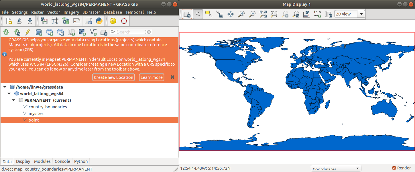
Starting GRASS
After launching GRASS for the first time, the GUI opens in a default
project world_latlong_wgs84. From there a new project can be created.
GRASS can be also started with a given database, project and mapset from the command line. For example, the following will start in a given mapset with only command line interface:
# Linux, Mac, *BSD, ...:
grass --text ~/grassdata/nc_spm_08_grass7/user1

# Windows
grass --text D:\grassdata\nc_spm_08_grass7\user1
And the following will create the given project with coordinate reference system given by the EPSG code and it will start the default interface (GUI or command line):
# Linux, Mac, *BSD, ...:
grass -c EPSG:5514:3 ~/grassdata/myproject

# Windows
grass -c EPSG:5514:3 D:\grassdata\myproject
See grass command manual for more details.
Creating a New Project with the Project Wizard
The GUI provides a graphical Project Wizard which lets you easily create a new project for your own data. You will be guided through a series of dialogues to browse and select predefined projections or to define custom projections.
The most convenient way of using the Project Wizard is creating new project based on a georeferenced file, such as Shapefile or GeoTIFF, or by selecting the corresponding EPSG code of the coordinate reference system. In case of using georeferenced file, you are asked whether the data itself should be imported into the new project. The default region is then set to match imported map.
If data were already imported, you can add them into the Layer Manager now and display them. More data can be imported into the project, e.g. using import options in the File menu in Layer Manager or r.import.
See also
- The grass command
- r.import, v.import, r.external, v.external, r.proj, v.proj
- Importing data on GRASS Wiki
SOURCE CODE
Available at: grass_database source code
(history)
Latest change: Thursday Mar 12 19:34:43 2026 in commit 4334ea5