NAME
r.noaa.atlas14 - Downloads and imports NOAA Atlas 14 precipitation-frequency data from the PFDS point service or official GIS grid packages.KEYWORDS
raster, hydrology, precipitation, vector, rainfall, NOAA, Atlas 14SYNOPSIS
Flags:
- -l
- List matching grid archives and exit (mode=grid)
- -k
- Keep downloaded archives
- -c
- Print point result to stdout even if output file is written
- -i
- Use r.import instead of r.in.gdal for grid import
- -o
- Override projection check when using r.in.gdal
- --overwrite
- Allow output files to overwrite existing files
- --help
- Print usage summary
- --verbose
- Verbose module output
- --quiet
- Quiet module output
- --ui
- Force launching GUI dialog
Parameters:
- mode=string [required]
- Data acquisition mode
- Options: point, grid
- statistic=string
- Statistic to request/import
- Options: depth, intensity
- Default: depth
- units=string
- Units for point queries; output units for grid rasters (does not filter grids)
- Options: english, metric
- Default: english
- series=string
- Time series type for point queries or for filtering grids
- Options: pds, ams
- Default: pds
- bound=string
- Bound to return/import
- Options: expected, upper, lower, all
- Default: expected
- coordinates=lon,lat[,lon,lat,...]
- Longitude,Latitude pair(s) in decimal degrees for mode=point; if omitted, the center of the computational region is used
- vector_output=name
- Optional output vector point map for mode=point
- output=string
- Optional path for point output file (.json or .csv) or grid manifest CSV
- format=string
- Output format for mode=point
- Options: json, csv
- Default: json
- float_format=string
- Python format string for CSV numeric output in mode=point
- Default: .3f
- region=string
- Atlas 14 grid region code, e.g. sw, orb, pr, hi, nmi, ch, ko, pp, nk, pg, yp, wl, ul, pl, rm, as, gu, wki, ak, mw, se, ne, tx, inw
- archive_url=string
- Direct URL to a NOAA grid ZIP archive or a directory listing page; overrides autodiscovery in mode=grid
- durations=string[,string,...]
- Duration filters for mode=grid, e.g. 5min,10min,24hr,2day
- aris=integer[,integer,...]
- Average recurrence intervals in years for mode=grid, e.g. 2,10,100
- output_prefix=string
- Prefix for imported raster names in mode=grid
- Default: a14
- resample=string
- Resampling method used by r.import in mode=grid
- Options: nearest, bilinear, bicubic, lanczos
- Default: nearest
- nearest: Nearest-neighbor interpolation
- bilinear: Bilinear interpolation
- bicubic: Bicubic interpolation
- base_gis_url=string
- Base HTTPS directory for NOAA Atlas 14 GIS data; used for grid autodiscovery
- Default: https://hdsc.nws.noaa.gov/pub/hdsc/data
- separator=string
- Separator for CSV-like outputs where relevant
- Options: comma, pipe, tab, space
- Default: comma
Table of contents
DESCRIPTION
r.noaa.atlas14 downloads and imports NOAA Atlas 14 precipitation-frequency data into GRASS. It supports two acquisition modes:- mode=point queries the NOAA Precipitation Frequency Data Server (PFDS) point-query endpoint for one or more longitude/latitude pairs and writes the returned precipitation-frequency estimates as JSON or CSV. Optionally, a GRASS vector point map is created with the expected/upper/lower tables stored as JSON attributes.
- mode=grid discovers, downloads, and imports NOAA Atlas 14 GIS-compatible grid archives (ZIP) for a given Atlas 14 volume/subregion, optionally filtered by duration, average recurrence interval (ARI), bound, statistic, units, and series. A manifest CSV describing the imported rasters can be written.
The module retrieves data directly from NOAA's public services:
- PFDS point query:
https://hdsc.nws.noaa.gov/cgi-bin/new/fe_text.csv - GIS grid archives:
https://hdsc.nws.noaa.gov/pub/hdsc/data/(autodiscovery), or any user-suppliedarchive_url=.
NOTES
Point mode
Point results include the expected value and the
upper/lower bounds of the 90% confidence interval, for
each duration/return-period combination published by NOAA. Use
bound=expected|upper|lower|all to select the table(s).
coordinates= accepts one or more lon,lat
pairs, e.g.
coordinates=-78.6382,35.7796,-81.0,29.5. When
coordinates= is omitted, the module queries the center of
the current computational region; the region bounds are reprojected to
WGS84 lon/lat via g.region -b so this works from any GRASS
location CRS.
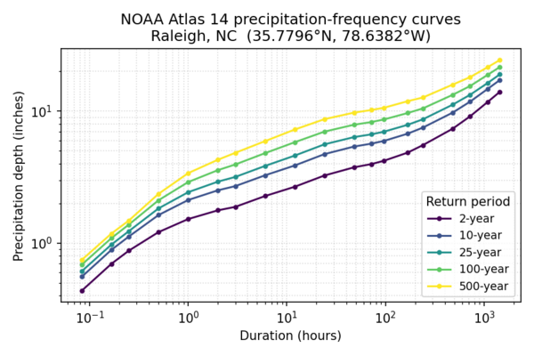
Figure: Precipitation-frequency (depth vs. duration) curves for Raleigh, North Carolina, produced from an
r.noaa.atlas14 mode=point query to the NOAA Precipitation
Frequency Data Server. Each curve is the expected value for the labeled
return period.
When multiple points are queried, JSON output is emitted as a list of
per-point result objects, and CSV output prepends
lon,lat,bound columns so rows from different points and
bounds can be disambiguated. Single-point output keeps the original
unwrapped format for backward compatibility.
The statistic option controls whether PFDS returns
precipitation depth or intensity. The
units option (english or metric)
and series option (pds or ams —
partial-duration or annual-maximum series) are passed through to
PFDS.
If vector_output= is given, the module creates a vector
point map with one feature per queried point and columns lon,
lat, expected_json, upper_json,
lower_json. Point geometries are reprojected from WGS84 into
the current project's CRS, while the lon/lat
columns keep the original WGS84 coordinates. The JSON columns contain the
full per-duration tables so they can be queried later with
v.db.select / db.select.
Grid mode
NOAA organizes Atlas 14 GIS archives under per-volume
subdirectories of base_gis_url=, e.g.
https://hdsc.nws.noaa.gov/pub/hdsc/data/se/ for Volume 9
Southeastern States. When region= is given, autodiscovery
fetches the listing at
<base_gis_url>/<region>/ and parses every
*.zip href.
Filenames follow a compact convention
<region><ari>yr<NN><unit>a[l|u][_ams].zip,
e.g.:
se2yr24ha.zip— Southeastern, 2-year ARI, 24-hour, expected, PDSorb1000yr30mau_ams.zip— Ohio River Basin, 1000-year, 30-minute, upper bound, AMSse1000yr60dal.zip— Southeastern, 1000-year, 60-day, lower bound, PDS
where <unit> is m, h, or
d (minute/hour/day), bound is absent for the expected value
and l/u for the lower/upper 90% confidence
bounds, and _ams marks the annual-maximum series (absent =
partial-duration series).
If autodiscovery fails or a custom mirror is used, pass
archive_url= directly with either a .zip URL
or a directory listing URL that contains the ZIPs.
The -l flag lists matching archives (as JSON lines)
without downloading them.
Filtering behavior:
durations=andaris=are strict: candidates whose duration or ARI could not be inferred from the filename are rejected.bound=andseries=are permissive: a candidate with an unknown attribute is allowed through, to avoid discarding rasters whose filenames do not encode every attribute.statistic=andunits=do not filter archives in grid mode. NOAA only publishes depth in english units, so the module always downloads that and rescales the imported rasters to the requestedstatistic/unitsas output targets.
Rasters are imported with r.in.gdal by default; pass
-i to use r.import (which supports reprojection
via resample=). Pass -o to override the
projection check when using r.in.gdal. Imported raster names
follow the pattern
<output_prefix>_<statistic>_<bound>_<duration>_<ari>yr_<units>_<series>_<region>,
with missing parts omitted.
Value encoding
NOAA Atlas 14 GIS grids encode precipitation depth as integer
1000ths of an inch in the raw archives. Grid mode converts the
imported rasters automatically, so no manual rescaling is needed: depth
is written in inches (or mm with units=metric) and intensity
in in/hr (or mm/hr), according to the requested statistic
and units. The raster units and title set by
r.support describe the converted values. NODATA cells become
GRASS NULLs on import, so the sentinel value (which varies by volume)
does not need to be handled.
Safety
Extracted ZIP members are validated against path traversal (zip-slip): any member whose resolved path escapes the temporary extraction directory causes the import to abort.
EXAMPLES
Point query to CSV
r.noaa.atlas14 mode=point coordinates=-78.6382,35.7796 \
    statistic=intensity units=english series=pds bound=expected \
    format=csv output=/tmp/raleigh_idf.csv
Point query to JSON and create a vector point
r.noaa.atlas14 mode=point coordinates=-78.6382,35.7796 \
    statistic=depth units=english series=pds bound=all \
    format=json output=/tmp/raleigh_atlas14.json \
    vector_output=atlas14_raleigh
Multiple points as a single CSV and a multi-point vector
r.noaa.atlas14 mode=point \
    coordinates=-78.6382,35.7796,-80.8431,35.2271,-77.8868,34.2257 \
    statistic=depth units=english series=pds bound=expected \
    format=csv output=/tmp/nc_cities_idf.csv \
    vector_output=atlas14_nc_cities
Query the center of the current computational region
g.region raster=elevation
r.noaa.atlas14 mode=point format=json bound=expected
List matching grid archives without importing
r.noaa.atlas14 mode=grid region=se -l
Import a known archive directly
r.noaa.atlas14 mode=grid \
    archive_url="https://hdsc.nws.noaa.gov/pub/hdsc/data/se/se100yr24ha.zip" \
    output_prefix=a14 -i
Import filtered subset and write a manifest
r.noaa.atlas14 mode=grid region=se \
    durations=24hr,2day aris=10,100 bound=expected \
    output_prefix=a14 output=/tmp/a14_manifest.csv -i
REFERENCES
- Bonnin, G. M., D. Martin, B. Lin, T. Parzybok, M. Yekta, and D. Riley (2004–2019), NOAA Atlas 14: Precipitation-Frequency Atlas of the United States. NOAA, National Weather Service, Silver Spring, Maryland.
- NOAA Precipitation Frequency Data Server (PFDS): https://hdsc.nws.noaa.gov/pfds/
SEE ALSO
r.import, r.in.gdal, r.sim.water, v.in.asciiAUTHORS
Corey T. White, NCSU GeoForAll LabSOURCE CODE
Available at: r.noaa.atlas14 source code (history)
Latest change: Wednesday Jun 03 10:49:06 2026 in commit: cb384e4f5e3ed4a44746946bc5ecc66a81f8858c
Main index | Raster index | Topics index | Keywords index | Graphical index | Full index
© 2003-2026 GRASS Development Team, GRASS 8.5.1dev Reference Manual