r.richdem.fsm
Apply one Fill-Spill-Merge step to redistribute surface water using RichDEM
r.richdem.fsm input=name labels=name flowdirs=name hierarchy=name water_depth=string output=name [--overwrite] [--verbose] [--quiet] [--qq] [--ui]
Example:
r.richdem.fsm input=name labels=name flowdirs=name hierarchy=name water_depth=string output=name
grass.tools.Tools.r_richdem_fsm(input, labels, flowdirs, hierarchy, water_depth, output, overwrite=None, verbose=None, quiet=None, superquiet=None)
Example:
tools = Tools()
tools.r_richdem_fsm(input="name", labels="name", flowdirs="name", hierarchy="name", water_depth="string", output="name")
This grass.tools API is experimental in version 8.5 and expected to be stable in version 8.6.
grass.script.run_command("r.richdem.fsm", input, labels, flowdirs, hierarchy, water_depth, output, overwrite=None, verbose=None, quiet=None, superquiet=None)
Example:
gs.run_command("r.richdem.fsm", input="name", labels="name", flowdirs="name", hierarchy="name", water_depth="string", output="name")
Parameters
input=name [required]
Input elevation raster
labels=name [required]
Depression labels raster (from r.richdem.dephier)
flowdirs=name [required]
Flow directions raster (from r.richdem.dephier)
hierarchy=name [required]
Depression hierarchy vector map (from r.richdem.dephier)
Or data source for direct OGR access
water_depth=string [required]
Depth of water to add (float value or raster map name)
Uniform depth as a float (e.g. 0.5) or a raster map name. Negative values mean water table is below the surface; positive values mean surface inundation.
output=name [required]
Output water table depth raster after redistribution
--overwrite
Allow output files to overwrite existing files
--help
Print usage summary
--verbose
Verbose module output
--quiet
Quiet module output
--qq
Very quiet module output
--ui
Force launching GUI dialog
input : str | np.ndarray, required
Input elevation raster
Used as: input, raster, name
labels : str | np.ndarray, required
Depression labels raster (from r.richdem.dephier)
Used as: input, raster, name
flowdirs : str | np.ndarray, required
Flow directions raster (from r.richdem.dephier)
Used as: input, raster, name
hierarchy : str, required
Depression hierarchy vector map (from r.richdem.dephier)
Or data source for direct OGR access
Used as: input, vector, name
water_depth : str, required
Depth of water to add (float value or raster map name)
Uniform depth as a float (e.g. 0.5) or a raster map name. Negative values mean water table is below the surface; positive values mean surface inundation.
output : str | type(np.ndarray) | type(np.array) | type(gs.array.array), required
Output water table depth raster after redistribution
Used as: output, raster, name
overwrite : bool, optional
Allow output files to overwrite existing files
Default: None
verbose : bool, optional
Verbose module output
Default: None
quiet : bool, optional
Quiet module output
Default: None
superquiet : bool, optional
Very quiet module output
Default: None
Returns:
result : grass.tools.support.ToolResult | np.ndarray | tuple[np.ndarray] | None
If the tool produces text as standard output, a ToolResult object will be returned. Otherwise, None will be returned. If an array type (e.g., np.ndarray) is used for one of the raster outputs, the result will be an array and will have the shape corresponding to the computational region. If an array type is used for more than one raster output, the result will be a tuple of arrays.
Raises:
grass.tools.ToolError: When the tool ended with an error.
input : str, required
Input elevation raster
Used as: input, raster, name
labels : str, required
Depression labels raster (from r.richdem.dephier)
Used as: input, raster, name
flowdirs : str, required
Flow directions raster (from r.richdem.dephier)
Used as: input, raster, name
hierarchy : str, required
Depression hierarchy vector map (from r.richdem.dephier)
Or data source for direct OGR access
Used as: input, vector, name
water_depth : str, required
Depth of water to add (float value or raster map name)
Uniform depth as a float (e.g. 0.5) or a raster map name. Negative values mean water table is below the surface; positive values mean surface inundation.
output : str, required
Output water table depth raster after redistribution
Used as: output, raster, name
overwrite : bool, optional
Allow output files to overwrite existing files
Default: None
verbose : bool, optional
Verbose module output
Default: None
quiet : bool, optional
Quiet module output
Default: None
superquiet : bool, optional
Very quiet module output
Default: None
DESCRIPTION
r.richdem.fsm applies the Fill--Spill--Merge algorithm (Barnes et al., 2021) to redistribute surface water across a landscape, respecting the topographic depression hierarchy computed by r.richdem.dephier. Unlike conventional flow-accumulation approaches that require depressions to be pre-filled, Fill--Spill--Merge retains real depressions and routes water through them explicitly.
The algorithm operates in three stages:
- Downslope routing --- surface water (positive water-table depth values) is routed downslope to pit cells using the precomputed flow directions, accumulating in the bottoms of depressions.
- Hierarchy traversal --- the depression hierarchy is traversed depth-first. When a depression fills to its pour-point elevation, excess water spills into the adjacent depression identified by the geolink. If both depressions are full they merge into their parent meta-depression, and water is redistributed across the combined volume. This continues until all water is accounted for or reaches the ocean.
- Water surface mapping --- the equilibrium water surface elevation in each depression is computed from the total water volume and the depression's hypsometry, then written back to the output raster as water-table depth.
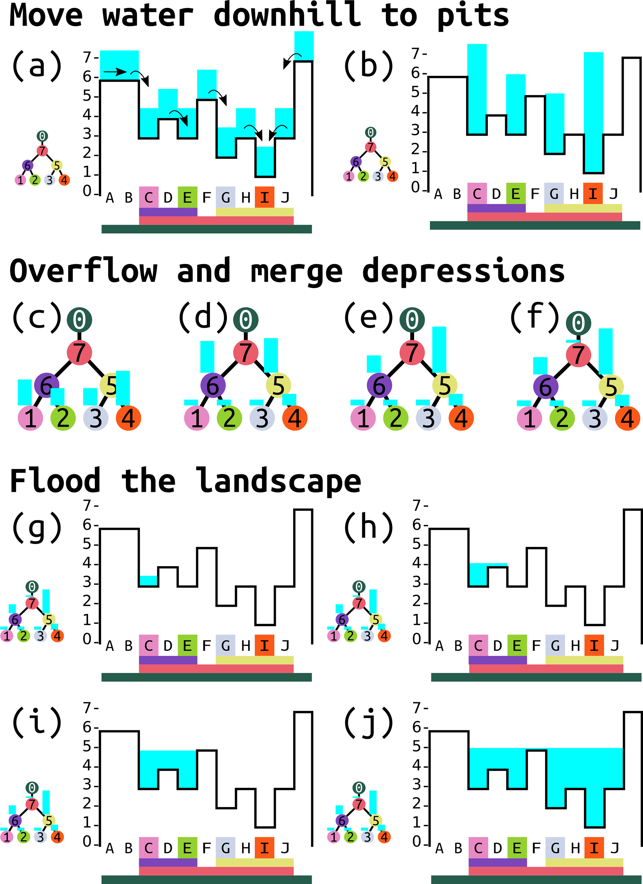 The three stages of the Fill--Spill--Merge algorithm illustrated on a
synthetic landscape. (a--b) Downslope routing moves surface water to pit
cells. (c--f) Hierarchy traversal: depressions fill, overflow at pour
points, and merge into meta-depressions. (g--j) Water surface mapping
back-calculates the equilibrium water-table depth in each depression from
the accumulated volume. Figure 4 from Barnes, Callaghan & Wickert (2021),
CC-BY 4.0.
The three stages of the Fill--Spill--Merge algorithm illustrated on a
synthetic landscape. (a--b) Downslope routing moves surface water to pit
cells. (c--f) Hierarchy traversal: depressions fill, overflow at pour
points, and merge into meta-depressions. (g--j) Water surface mapping
back-calculates the equilibrium water-table depth in each depression from
the accumulated volume. Figure 4 from Barnes, Callaghan & Wickert (2021),
CC-BY 4.0.
Water table depth convention
The water_depth and output maps use a signed depth convention:
- Values \< 0: water table is below the land surface by that magnitude (e.g., −0.5 means 0.5 m below surface).
- Value = 0: water table is exactly at the land surface (saturated).
- Values > 0: standing surface water of that depth above the land surface (the cell is inundated).
Equilibrium solution
Fill--Spill--Merge produces an equilibrium (steady-state) solution for a given water input. The result is path-independent: applying a uniform water depth all at once gives the same equilibrium as applying it incrementally. Multiple time steps are therefore only needed when water inputs or topography change between steps.
NOTES
All three raster inputs (input, labels, flowdirs) and the vector hierarchy must have been produced by r.richdem.dephier from the same DEM without any modification to the DEM or computational region in between.
In addition to writing the output raster, this module updates the water_vol column of the depression hierarchy vector map's attribute table to reflect the volume of water in each depression after redistribution. This keeps the hierarchy consistent with the output raster for subsequent analysis or additional FSM steps.
Fill--Spill--Merge runs approximately 90--2600× faster than iterative (Jacobi-style) approaches because it solves the redistribution problem algebraically using the hierarchy structure rather than by iterative relaxation (Barnes et al., 2021).
REQUIREMENTS
This module requires the RichDEM Python package, which is not a standard GRASS GIS dependency and must be installed separately:
pip install richdem
If pip install richdem fails (the package requires a C++ compiler), build
from source:
git clone https://github.com/r-barnes/richdem.git
cd richdem/wrappers/pyrichdem
pip install -e .
Ensure that RichDEM is installed into the same Python environment used by GRASS GIS.
EXAMPLES
Full Fill--Spill--Merge workflow starting from a raw DEM:
# Step 1: build the depression hierarchy
r.richdem.dephier input=dem \
    output_labels=dep_labels \
    output_flowdirs=dep_flowdirs \
    output_hierarchy=dep_hierarchy

# Step 2: create an initial water table depth map
# (here: uniformly 0.5 m below the surface)
r.mapcalc "wtd_initial = -0.5"

# Step 3: run Fill-Spill-Merge
r.richdem.fsm input=dem \
    labels=dep_labels \
    flowdirs=dep_flowdirs \
    hierarchy=dep_hierarchy \
    water_depth=wtd_initial \
    output=wtd_after
Inspect where surface water accumulated after redistribution:
r.mapcalc "surface_water = if(wtd_after > 0, wtd_after, null())"
r.colors map=surface_water color=water
Check updated water volumes in each depression:
v.db.select map=dep_hierarchy layer=1 columns=dep_label,water_vol where="water_vol > 0"
REFERENCES
- Barnes, R., Callaghan, K.L., Wickert, A.D. (2021). Computing water flow through complex landscapes -- Part 3: Fill--Spill--Merge: flow routing in depression hierarchies. Earth Surface Dynamics Vol 9(1), pp 105--121. DOI: 10.5194/esurf-9-105-2021
- Barnes, R., Callaghan, K.L., Wickert, A.D. (2020). Computing water flow through complex landscapes -- Part 2: Finding hierarchies in depressions and morphological segmentations. Earth Surface Dynamics Vol 8(2), pp 431--445. DOI: 10.5194/esurf-8-431-2020
- Barnes, R. (2016). RichDEM: Terrain Analysis Software. URL: http://github.com/r-barnes/richdem
SEE ALSO
r.richdem.dephier, r.richdem.filldepressions, r.richdem.flowaccumulation, r.watershed, r.lake
AUTHORS
Richard Barnes, Kerry L. Callaghan, Andrew D. Wickert (Barnes et al., 2021)
GRASS GIS bindings: Andrew D. Wickert, with assistance from Claude Sonnet 4.6
SOURCE CODE
Available at: r.richdem.fsm source code
(history)
Latest change: Sunday May 31 20:21:19 2026 in commit 2163cf6