d.grid
Overlays a user-specified grid in the active display frame on the graphics monitor.
d.grid [-agwcdfnbt] size=value [origin=east,north] [direction=string] [width=float] [color=name] [border_color=name] [text_color=name] [bgcolor=name] [fontsize=integer] [--verbose] [--quiet] [--qq] [--ui]
Example:
d.grid size=value
grass.tools.Tools.d_grid(size, origin="0,0", direction="both", width=None, color="gray", border_color="black", text_color="gray", bgcolor="none", fontsize=9, flags=None, verbose=None, quiet=None, superquiet=None)
Example:
tools = Tools()
tools.d_grid(size="value")
This grass.tools API is experimental in version 8.5 and expected to be stable in version 8.6.
grass.script.parse_command("d.grid", size, origin="0,0", direction="both", width=None, color="gray", border_color="black", text_color="gray", bgcolor="none", fontsize=9, flags=None, verbose=None, quiet=None, superquiet=None)
Example:
gs.parse_command("d.grid", size="value")
Parameters
size=value [required]
Size of grid to be drawn (in map units)
0 for north-south resolution of the current region. In map units or DDD:MM:SS format. Example: "1000" or "0:10"
origin=east,north
Lines of the grid pass through this coordinate
Default: 0,0
direction=string
Draw only east-west lines, north-south lines, or both
Allowed values: both, east-west, north-south
Default: both
width=float
Grid line width
color=name
Grid color
Either a standard color name or R:G:B triplet
Default: gray
border_color=name
Border color
Either a standard color name or R:G:B triplet
Default: black
text_color=name
Text color
Either a standard color name or R:G:B triplet
Default: gray
bgcolor=name
Background color
Either a standard color name, R:G:B triplet, or "none"
Default: none
fontsize=integer
Font size for gridline coordinate labels
Allowed values: 1-72
Default: 9
-a
Align the origin to the east-north corner of the current region
-g
Draw geographic grid (referenced to current ellipsoid)
-w
Draw geographic grid (referenced to WGS84 ellipsoid)
-c
Draw '+' marks instead of grid lines
-d
Draw '.' marks instead of grid lines
-f
Draw fiducial marks instead of grid lines
-n
Disable grid drawing
-b
Disable border drawing
-t
Disable text drawing
--help
Print usage summary
--verbose
Verbose module output
--quiet
Quiet module output
--qq
Very quiet module output
--ui
Force launching GUI dialog
size : str, required
Size of grid to be drawn (in map units)
0 for north-south resolution of the current region. In map units or DDD:MM:SS format. Example: "1000" or "0:10"
Used as: value
origin : tuple[float, float] | list[float] | str, optional
Lines of the grid pass through this coordinate
Used as: input, coords, east,north
Default: 0,0
direction : str, optional
Draw only east-west lines, north-south lines, or both
Allowed values: both, east-west, north-south
Default: both
width : float, optional
Grid line width
color : str, optional
Grid color
Either a standard color name or R:G:B triplet
Used as: input, color, name
Default: gray
border_color : str, optional
Border color
Either a standard color name or R:G:B triplet
Used as: input, color, name
Default: black
text_color : str, optional
Text color
Either a standard color name or R:G:B triplet
Used as: input, color, name
Default: gray
bgcolor : str, optional
Background color
Either a standard color name, R:G:B triplet, or "none"
Used as: input, color, name
Default: none
fontsize : int, optional
Font size for gridline coordinate labels
Allowed values: 1-72
Default: 9
flags : str, optional
Allowed values: a, g, w, c, d, f, n, b, t
a
Align the origin to the east-north corner of the current region
g
Draw geographic grid (referenced to current ellipsoid)
w
Draw geographic grid (referenced to WGS84 ellipsoid)
c
Draw '+' marks instead of grid lines
d
Draw '.' marks instead of grid lines
f
Draw fiducial marks instead of grid lines
n
Disable grid drawing
b
Disable border drawing
t
Disable text drawing
verbose : bool, optional
Verbose module output
Default: None
quiet : bool, optional
Quiet module output
Default: None
superquiet : bool, optional
Very quiet module output
Default: None
Returns:
result : grass.tools.support.ToolResult | None
If the tool produces text as standard output, a ToolResult object will be returned. Otherwise, None will be returned.
Raises:
grass.tools.ToolError: When the tool ended with an error.
size : str, required
Size of grid to be drawn (in map units)
0 for north-south resolution of the current region. In map units or DDD:MM:SS format. Example: "1000" or "0:10"
Used as: value
origin : tuple[float, float] | list[float] | str, optional
Lines of the grid pass through this coordinate
Used as: input, coords, east,north
Default: 0,0
direction : str, optional
Draw only east-west lines, north-south lines, or both
Allowed values: both, east-west, north-south
Default: both
width : float, optional
Grid line width
color : str, optional
Grid color
Either a standard color name or R:G:B triplet
Used as: input, color, name
Default: gray
border_color : str, optional
Border color
Either a standard color name or R:G:B triplet
Used as: input, color, name
Default: black
text_color : str, optional
Text color
Either a standard color name or R:G:B triplet
Used as: input, color, name
Default: gray
bgcolor : str, optional
Background color
Either a standard color name, R:G:B triplet, or "none"
Used as: input, color, name
Default: none
fontsize : int, optional
Font size for gridline coordinate labels
Allowed values: 1-72
Default: 9
flags : str, optional
Allowed values: a, g, w, c, d, f, n, b, t
a
Align the origin to the east-north corner of the current region
g
Draw geographic grid (referenced to current ellipsoid)
w
Draw geographic grid (referenced to WGS84 ellipsoid)
c
Draw '+' marks instead of grid lines
d
Draw '.' marks instead of grid lines
f
Draw fiducial marks instead of grid lines
n
Disable grid drawing
b
Disable border drawing
t
Disable text drawing
verbose : bool, optional
Verbose module output
Default: None
quiet : bool, optional
Quiet module output
Default: None
superquiet : bool, optional
Very quiet module output
Default: None
DESCRIPTION
d.grid overlays a grid of user-defined size and color in the active display frame on the graphics monitor. The grid can be created as a standard rectangular grid or a geographic grid.
If the user provides a -g flag a geographic (projected) grid will be
drawn. With the -g flag the size argument accepts both decimal
degrees and colon separated ddd ss coordinates (eg.
 00:30:00 for
half of a degree). A geographic grid cannot be drawn for a
latitude/longitude or XY projection.
Colors may be standard named GRASS colors (red, green, aqua, etc.) or a numerical R:G:B triplet, where component values range from 0-255. Grid color can be set with option color. Options text_color and bgcolor set the color of the text and its background.
The grid drawing may be turned off by using the -n flag.
The border drawing may be turned off by using the -b flag.
The coordinate text may be turned off by using the -t flag.
To draw grid lines at different intervals, e.g. at high latitudes, you can run the module twice, once with direction=east-west at one interval size, and again with direction=north-south at another interval size.
EXAMPLES
To draw a red geographic grid with 30 minute grid spacing, run one of the following commands:
d.grid -g size=00:30:00 color=red
or
d.grid -g size=0.5 color=255:0:0
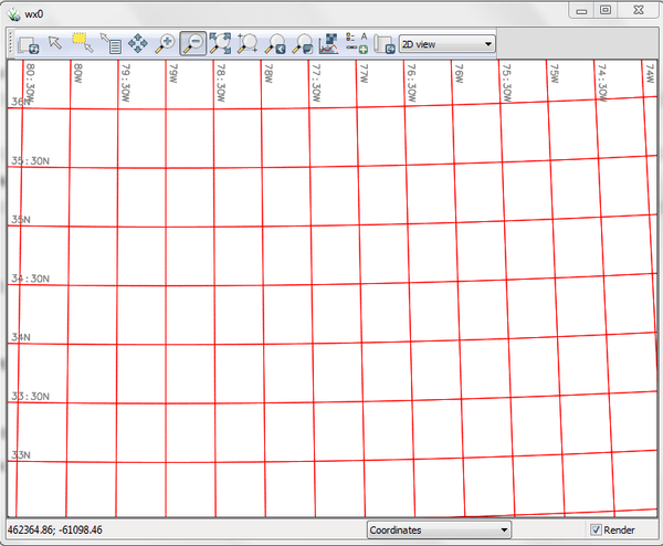
Figure: Showing a geographic grid in red line color
To draw a blue standard rectangular grid at a 500 (meter) spacing run the following:
d.grid size=500 color=blue
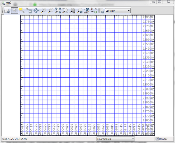
Figure: Showing a rectangular grid in blue line color
SEE ALSO
d.barscale, d.legend, d.geodesic, d.rhumbline, d.erase, d.frame, d.rast, v.mkgrid
AUTHORS
James Westervelt, U.S. Army Construction Engineering Research
Laboratory
Geogrid support: Bob Covill
Border support: Markus Neteler
Text and RGB support: Hamish Bowman
Background color implemented as part of GSoC 2016 by Adam Laza, CTU in
Prague
SOURCE CODE
Available at: d.grid source code
(history)
Latest change: Monday Dec 08 21:47:55 2025 in commit d3c6479