r.skyview
Computes skyview factor visualization technique.
r.skyview [-on] input=name output=name ndir=integer [maxdistance=float] [color_source=string] [color_input=name] [color_table=string] [colorized_output=name] [basename=string] [nprocs=integer] [memory=memory in MB] [--overwrite] [--verbose] [--quiet] [--qq] [--ui]
Example:
r.skyview input=name output=name ndir=16
grass.tools.Tools.r_skyview(input, output, ndir=16, maxdistance=None, color_source="input", color_input=None, color_table=None, colorized_output=None, basename=None, nprocs=0, memory=300, flags=None, overwrite=None, verbose=None, quiet=None, superquiet=None)
Example:
tools = Tools()
tools.r_skyview(input="name", output="name", ndir=16)
This grass.tools API is experimental in version 8.5 and expected to be stable in version 8.6.
grass.script.run_command("r.skyview", input, output, ndir=16, maxdistance=None, color_source="input", color_input=None, color_table=None, colorized_output=None, basename=None, nprocs=0, memory=300, flags=None, overwrite=None, verbose=None, quiet=None, superquiet=None)
Example:
gs.run_command("r.skyview", input="name", output="name", ndir=16)
Parameters
input=name [required]
Name of input raster map
output=name [required]
Name for output raster map
ndir=integer [required]
Number of directions (8 to 32 recommended)
Allowed values: 2-360
Default: 16
maxdistance=float
The maximum distance to consider when finding the horizon height
color_source=string
Source raster for colorization
Input and color_input are taken from input and color_input options respectively. The rest is computed using r.slope.aspect
Allowed values: input, color_input, slope, aspect, dxy
Default: input
input: use the raster from the input option
color_input: use the raster from the color_input option
slope: compute and use slope
aspect: compute and use aspect
dxy: compute and use second order partial derivative dxy
color_input=name
Custom raster map to be used for colorization
color_table=string
Color table for colorization raster (preset color table by default)
If empty, the color table of the created raster is used (not used at all for input and color_input)
Allowed values: reds, blues, greens, oranges, sepia, aspectcolr
colorized_output=name
Colorized sky-view factor
basename=string
Set the basename for the intermediate maps
nprocs=integer
Number of threads for parallel computing
0: use OpenMP default; >0: use nprocs; <0: use MAX-nprocs
Default: 0
memory=memory in MB
Maximum memory to be used (in MB)
Cache size for raster rows
Default: 300
-o
Compute openness instead of skyview factor
Openness considers zenith angles > 90 degrees
-n
Invert color table for colorization raster
Ignored for input and color_input
--overwrite
Allow output files to overwrite existing files
--help
Print usage summary
--verbose
Verbose module output
--quiet
Quiet module output
--qq
Very quiet module output
--ui
Force launching GUI dialog
input : str | np.ndarray, required
Name of input raster map
Used as: input, raster, name
output : str | type(np.ndarray) | type(np.array) | type(gs.array.array), required
Name for output raster map
Used as: output, raster, name
ndir : int, required
Number of directions (8 to 32 recommended)
Allowed values: 2-360
Default: 16
maxdistance : float, optional
The maximum distance to consider when finding the horizon height
color_source : str, optional
Source raster for colorization
Input and color_input are taken from input and color_input options respectively. The rest is computed using r.slope.aspect
Allowed values: input, color_input, slope, aspect, dxy
input: use the raster from the input option
color_input: use the raster from the color_input option
slope: compute and use slope
aspect: compute and use aspect
dxy: compute and use second order partial derivative dxy
Default: input
color_input : str | np.ndarray, optional
Custom raster map to be used for colorization
Used as: input, raster, name
color_table : str, optional
Color table for colorization raster (preset color table by default)
If empty, the color table of the created raster is used (not used at all for input and color_input)
Allowed values: reds, blues, greens, oranges, sepia, aspectcolr
colorized_output : str | type(np.ndarray) | type(np.array) | type(gs.array.array), optional
Colorized sky-view factor
Used as: output, raster, name
basename : str, optional
Set the basename for the intermediate maps
nprocs : int, optional
Number of threads for parallel computing
0: use OpenMP default; >0: use nprocs; <0: use MAX-nprocs
Default: 0
memory : int, optional
Maximum memory to be used (in MB)
Cache size for raster rows
Used as: memory in MB
Default: 300
flags : str, optional
Allowed values: o, n
o
Compute openness instead of skyview factor
Openness considers zenith angles > 90 degrees
n
Invert color table for colorization raster
Ignored for input and color_input
overwrite : bool, optional
Allow output files to overwrite existing files
Default: None
verbose : bool, optional
Verbose module output
Default: None
quiet : bool, optional
Quiet module output
Default: None
superquiet : bool, optional
Very quiet module output
Default: None
Returns:
result : grass.tools.support.ToolResult | np.ndarray | tuple[np.ndarray] | None
If the tool produces text as standard output, a ToolResult object will be returned. Otherwise, None will be returned. If an array type (e.g., np.ndarray) is used for one of the raster outputs, the result will be an array and will have the shape corresponding to the computational region. If an array type is used for more than one raster output, the result will be a tuple of arrays.
Raises:
grass.tools.ToolError: When the tool ended with an error.
input : str, required
Name of input raster map
Used as: input, raster, name
output : str, required
Name for output raster map
Used as: output, raster, name
ndir : int, required
Number of directions (8 to 32 recommended)
Allowed values: 2-360
Default: 16
maxdistance : float, optional
The maximum distance to consider when finding the horizon height
color_source : str, optional
Source raster for colorization
Input and color_input are taken from input and color_input options respectively. The rest is computed using r.slope.aspect
Allowed values: input, color_input, slope, aspect, dxy
input: use the raster from the input option
color_input: use the raster from the color_input option
slope: compute and use slope
aspect: compute and use aspect
dxy: compute and use second order partial derivative dxy
Default: input
color_input : str, optional
Custom raster map to be used for colorization
Used as: input, raster, name
color_table : str, optional
Color table for colorization raster (preset color table by default)
If empty, the color table of the created raster is used (not used at all for input and color_input)
Allowed values: reds, blues, greens, oranges, sepia, aspectcolr
colorized_output : str, optional
Colorized sky-view factor
Used as: output, raster, name
basename : str, optional
Set the basename for the intermediate maps
nprocs : int, optional
Number of threads for parallel computing
0: use OpenMP default; >0: use nprocs; <0: use MAX-nprocs
Default: 0
memory : int, optional
Maximum memory to be used (in MB)
Cache size for raster rows
Used as: memory in MB
Default: 300
flags : str, optional
Allowed values: o, n
o
Compute openness instead of skyview factor
Openness considers zenith angles > 90 degrees
n
Invert color table for colorization raster
Ignored for input and color_input
overwrite : bool, optional
Allow output files to overwrite existing files
Default: None
verbose : bool, optional
Verbose module output
Default: None
quiet : bool, optional
Quiet module output
Default: None
superquiet : bool, optional
Very quiet module output
Default: None
DESCRIPTION
Module r.skyview computes skyview factor, a relief visualization technique (Zaksek et al. 2011). The value of each cell is given by the portion of visible sky (from that cell) limited by the surrounding relief. The values range from 0 to 1. The lighter the value is, the more open the terrain is.
When flag -o is set, r.skyview computes openness instead of skyview factor. Openness (based on positive openness by Yokoyama et al. 2002) takes into account zenith angles greater than 90 degrees, while skyview limits zenith angles to 90 degrees (celestial hemisphere). This makes difference for example for visualization of horizontal planes and slopes. Openness values range from 0 to 2.
NOTES
Module r.horizon is used to compute elevation angles.
EXAMPLES
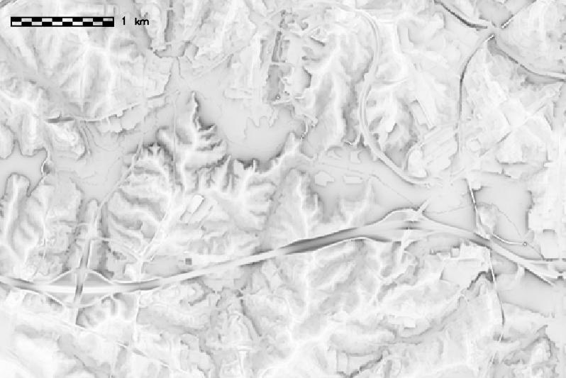
We compute the skyview factor map of the North Carolina sample dataset
elevation map:
g.region raster=elevation
r.skyview input=elevation output=elevation_skyview ndir=8
SEE ALSO
r.horizon, r.relief, r.shaded.pca, r.local.relief
REFERENCES
- Zaksek K, Ostir K, Kokalj Z. Sky-View Factor as a Relief Visualization Technique. Remote Sensing. 2011; 3(2):398-415.
- Yokoyama R, Shirasawa M, Pike J R. Visualizing topography by Openness: A new application of image processing to digital elevation models. Photogrammetric engineering and remote sensing 68.3 (2002): 257-266.
AUTHOR
Anna Petrasova, NCSU GeoForAll
SOURCE CODE
Available at: r.skyview source code
(history)
Latest change: Wednesday Jun 24 04:50:30 2026 in commit 54496cf