NAME
r.blend - Blends color components of two raster maps by a given ratio.KEYWORDS
raster, compositeSYNOPSIS
r.blend
r.blend --helpr.blend [-c] first=name second=name output=basename [percent=float] [nprocs=integer] [--overwrite] [--help] [--verbose] [--quiet] [--ui]
Flags:
- -c
- Combine resulting R,G,B layers into single output map
- --overwrite
- Allow output files to overwrite existing files
- --help
- Print usage summary
- --verbose
- Verbose module output
- --quiet
- Quiet module output
- --ui
- Force launching GUI dialog
Parameters:
- first=name [required]
- Name of first raster map for blending
- second=name [required]
- Name of second raster map for blending
- output=basename [required]
- Basename for red, green and blue output raster maps
- percent=float
- Percentage weight of first map for color blending
- Options: 0-100
- Default: 50
- nprocs=integer
- Number of threads for parallel computing
- 0: use OpenMP default; >0: use nprocs; <0: use MAX-nprocs
- Default: 0
Table of contents
DESCRIPTION
r.blend blends color components of 2 raster maps by a specified percentage of the first map.EXAMPLE
Blending the aspect map with the elevation map for a shaded map (North Carolina sample dataset):g.region raster=elevation r.relief input=elevation output=relief zscale=10 r.blend -c first=elevation second=relief output=blend percent=75
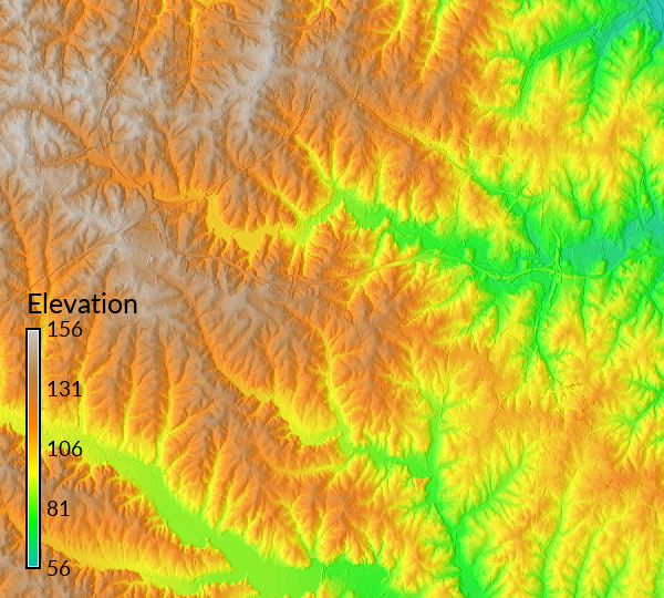
Figure: Elevation blended with shaded relief
SEE ALSO
d.shade, g.region, r.shade, r.colors, r.his, r.mapcalc, r.rgb, r.supportAUTHORS
Unknown: probably CERLUpdated to GRASS 5.7 by Michael Barton, Arizona State University
SOURCE CODE
Available at: r.blend source code (history)
Latest change: Thursday Nov 06 23:50:00 2025 in commit: f714bf80e54f853796854f03b5c86fd7f5b1cd9d
Main index | Raster index | Topics index | Keywords index | Graphical index | Full index
© 2003-2026 GRASS Development Team, GRASS 8.5.1dev Reference Manual