r.in.usgs
Download user-requested products through the USGS TNM API
r.in.usgs [-idk] product=string [output_name=name] [ned_dataset=string] [ned_release=string] [input_srs=string] [resolution=float] [title_filter=string] [resampling_method=string] [memory=integer] [nprocs=integer] cache_size_tolerance=integer [output_directory=name] [--overwrite] [--verbose] [--quiet] [--qq] [--ui]
Example:
r.in.usgs product=string output_name=name cache_size_tolerance=20
grass.tools.Tools.r_in_usgs(product, output_name=None, ned_dataset="ned1sec", ned_release="current", input_srs=None, resolution=None, title_filter=None, resampling_method="default", memory=300, nprocs=1, cache_size_tolerance=20, output_directory=None, flags=None, overwrite=None, verbose=None, quiet=None, superquiet=None)
Example:
tools = Tools()
tools.r_in_usgs(product="string", output_name="name", cache_size_tolerance=20)
This grass.tools API is experimental in version 8.5 and expected to be stable in version 8.6.
grass.script.run_command("r.in.usgs", product, output_name=None, ned_dataset="ned1sec", ned_release="current", input_srs=None, resolution=None, title_filter=None, resampling_method="default", memory=300, nprocs=1, cache_size_tolerance=20, output_directory=None, flags=None, overwrite=None, verbose=None, quiet=None, superquiet=None)
Example:
gs.run_command("r.in.usgs", product="string", output_name="name", cache_size_tolerance=20)
Parameters
product=string [required]
USGS data product
Available USGS data products to query
Allowed values: ned, naip, lidar
output_name=name
Name for output raster map
ned_dataset=string
NED dataset
Available NED datasets to query
Allowed values: ned1sec, ned13sec, ned19sec
Default: ned1sec
ned1sec: NED 1 arc-second
ned13sec: NED 1/3 arc-second
ned19sec: NED 1/9 arc-second
ned_release=string
NED data release
Restrict the NED dataset to the current (most recent) tiles, superseded historical tiles, or all of them
Allowed values: current, historical, all
Default: current
current: Current (most recent) tiles only
historical: Historical (superseded) tiles only
all: Current and historical tiles
input_srs=string
Input lidar dataset projection (WKT or EPSG, e.g. EPSG:4326)
Override input lidar dataset coordinate system using EPSG code or WKT definition
resolution=float
Resolution of lidar-based DSM
title_filter=string
Filter available tiles by their title (e.g. use "Phase4")
To avoid combining tiles from multiple years, use first -i flag and filter by tile title.
resampling_method=string
Resampling method to use
Allowed values: default, nearest, bilinear, bicubic, lanczos, bilinear_f, bicubic_f, lanczos_f
Default: default
default: default method based on product
nearest: nearest neighbor
bilinear: bilinear interpolation
bicubic: bicubic interpolation
lanczos: lanczos filter
bilinear_f: bilinear interpolation with fallback
bicubic_f: bicubic interpolation with fallback
lanczos_f: lanczos filter with fallback
memory=integer
Maximum memory to be used (in MB)
Cache size for raster rows during import and reprojection
Default: 300
nprocs=integer
Number of processes which will be used for parallel import and reprojection
Default: 1
cache_size_tolerance=integer [required]
Tolerance for file size difference between cached file and stated download size
The size difference is used to recognize failed downloads and corrupted files, but some difference occurs naturally
Default: 20
output_directory=name
Cache directory for download and processing
Defaults to system user cache directory (e.g., .cache)
-i
Return USGS data information without downloading files
-d
Download files only
-k
Keep imported tiles in the mapset after patch
--overwrite
Allow output files to overwrite existing files
--help
Print usage summary
--verbose
Verbose module output
--quiet
Quiet module output
--qq
Very quiet module output
--ui
Force launching GUI dialog
product : str, required
USGS data product
Available USGS data products to query
Allowed values: ned, naip, lidar
output_name : str | type(np.ndarray) | type(np.array) | type(gs.array.array), optional
Name for output raster map
Used as: output, raster, name
ned_dataset : str, optional
NED dataset
Available NED datasets to query
Allowed values: ned1sec, ned13sec, ned19sec
ned1sec: NED 1 arc-second
ned13sec: NED 1/3 arc-second
ned19sec: NED 1/9 arc-second
Default: ned1sec
ned_release : str, optional
NED data release
Restrict the NED dataset to the current (most recent) tiles, superseded historical tiles, or all of them
Allowed values: current, historical, all
current: Current (most recent) tiles only
historical: Historical (superseded) tiles only
all: Current and historical tiles
Default: current
input_srs : str, optional
Input lidar dataset projection (WKT or EPSG, e.g. EPSG:4326)
Override input lidar dataset coordinate system using EPSG code or WKT definition
resolution : float, optional
Resolution of lidar-based DSM
title_filter : str, optional
Filter available tiles by their title (e.g. use "Phase4")
To avoid combining tiles from multiple years, use first -i flag and filter by tile title.
resampling_method : str, optional
Resampling method to use
Allowed values: default, nearest, bilinear, bicubic, lanczos, bilinear_f, bicubic_f, lanczos_f
default: default method based on product
nearest: nearest neighbor
bilinear: bilinear interpolation
bicubic: bicubic interpolation
lanczos: lanczos filter
bilinear_f: bilinear interpolation with fallback
bicubic_f: bicubic interpolation with fallback
lanczos_f: lanczos filter with fallback
Default: default
memory : int, optional
Maximum memory to be used (in MB)
Cache size for raster rows during import and reprojection
Default: 300
nprocs : int, optional
Number of processes which will be used for parallel import and reprojection
Default: 1
cache_size_tolerance : int, required
Tolerance for file size difference between cached file and stated download size
The size difference is used to recognize failed downloads and corrupted files, but some difference occurs naturally
Default: 20
output_directory : str, optional
Cache directory for download and processing
Defaults to system user cache directory (e.g., .cache)
Used as: input, dir, name
flags : str, optional
Allowed values: i, d, k
i
Return USGS data information without downloading files
d
Download files only
k
Keep imported tiles in the mapset after patch
overwrite : bool, optional
Allow output files to overwrite existing files
Default: None
verbose : bool, optional
Verbose module output
Default: None
quiet : bool, optional
Quiet module output
Default: None
superquiet : bool, optional
Very quiet module output
Default: None
Returns:
result : grass.tools.support.ToolResult | np.ndarray | tuple[np.ndarray] | None
If the tool produces text as standard output, a ToolResult object will be returned. Otherwise, None will be returned. If an array type (e.g., np.ndarray) is used for one of the raster outputs, the result will be an array and will have the shape corresponding to the computational region. If an array type is used for more than one raster output, the result will be a tuple of arrays.
Raises:
grass.tools.ToolError: When the tool ended with an error.
product : str, required
USGS data product
Available USGS data products to query
Allowed values: ned, naip, lidar
output_name : str, optional
Name for output raster map
Used as: output, raster, name
ned_dataset : str, optional
NED dataset
Available NED datasets to query
Allowed values: ned1sec, ned13sec, ned19sec
ned1sec: NED 1 arc-second
ned13sec: NED 1/3 arc-second
ned19sec: NED 1/9 arc-second
Default: ned1sec
ned_release : str, optional
NED data release
Restrict the NED dataset to the current (most recent) tiles, superseded historical tiles, or all of them
Allowed values: current, historical, all
current: Current (most recent) tiles only
historical: Historical (superseded) tiles only
all: Current and historical tiles
Default: current
input_srs : str, optional
Input lidar dataset projection (WKT or EPSG, e.g. EPSG:4326)
Override input lidar dataset coordinate system using EPSG code or WKT definition
resolution : float, optional
Resolution of lidar-based DSM
title_filter : str, optional
Filter available tiles by their title (e.g. use "Phase4")
To avoid combining tiles from multiple years, use first -i flag and filter by tile title.
resampling_method : str, optional
Resampling method to use
Allowed values: default, nearest, bilinear, bicubic, lanczos, bilinear_f, bicubic_f, lanczos_f
default: default method based on product
nearest: nearest neighbor
bilinear: bilinear interpolation
bicubic: bicubic interpolation
lanczos: lanczos filter
bilinear_f: bilinear interpolation with fallback
bicubic_f: bicubic interpolation with fallback
lanczos_f: lanczos filter with fallback
Default: default
memory : int, optional
Maximum memory to be used (in MB)
Cache size for raster rows during import and reprojection
Default: 300
nprocs : int, optional
Number of processes which will be used for parallel import and reprojection
Default: 1
cache_size_tolerance : int, required
Tolerance for file size difference between cached file and stated download size
The size difference is used to recognize failed downloads and corrupted files, but some difference occurs naturally
Default: 20
output_directory : str, optional
Cache directory for download and processing
Defaults to system user cache directory (e.g., .cache)
Used as: input, dir, name
flags : str, optional
Allowed values: i, d, k
i
Return USGS data information without downloading files
d
Download files only
k
Keep imported tiles in the mapset after patch
overwrite : bool, optional
Allow output files to overwrite existing files
Default: None
verbose : bool, optional
Verbose module output
Default: None
quiet : bool, optional
Quiet module output
Default: None
superquiet : bool, optional
Very quiet module output
Default: None
DESCRIPTION
r.in.usgs downloads and patches selected USGS datasets (NED, NAIP, lidar) to the current GRASS computational region and coordinate reference system. Associated parameters are automatically passed to The National Map Access API, downloaded to a local cache directory, then imported, and patched together. r.in.usgs supports the following datasets:
- ned: National Elevation Dataset
- naip: NAIP orthoimagery
- lidar: Lidar Point Clouds (LPC)
National Land Cover Dataset (NLCD) is no longer available through the API.
NOTES
NED data are available at resolutions of 1 arc-second (about 30 meters), 1/3 arc-second (about 10 meters), and in limited areas at 1/9 arc-second (about 3 meters). USGS periodically re-collects and re-publishes NED tiles. Use ned_release to choose between the current (most recent) tiles (default), the historical (superseded) tiles, or all of them. This applies only to the 1 arc-second and 1/3 arc-second datasets; the 1/9 arc-second dataset is not split this way, so all of its tiles are always used. When multiple tiles overlap, use the i flag to list them first and title_filter to select a specific one.
NAIP is available at 1 m resolution.
Lidar data is available only for part of the US but there can be multiple spatially overlapping datasets from different years. All point clouds will be imported as points using v.in.pdal and then patched and interpolated with v.surf.rst. In some cases, lidar point clouds do not have SRS information, use input_srs to specify it (e.g. "EPSG:2264"). If multiple tiles from different years are available, use title_filter to filter by their titles (e.g. "Phase1"). Use i flag to list the tiles first.
If the i flag is set, only information about data meeting the input parameters is displayed without downloading the data. If the d flag is set, data is downloaded but not imported and processed.
By default, downloaded files are kept in a user cache directory
according to the operating system standards. These files can be reused
in case a different, but overlapping, computational region is required.
However, unzipped files and imported rasters before patching are
removed. If the k flag is set, extracted files from compressed
archives are also kept within the cache directory after the import. The
location of the cache directory depends on the operating system. You can
clear the cache by deleting the directory. Where this directory is
depends on operating system, for example on Linux, it is under
~/.cache, on macOS under ~/Library/Caches, and on Microsoft Windows
under the Application Data directory. If you have limited space or other
special needs, you can set output_directory to a custom directory,
e.g., /tmp on Linux. The custom directory needs to exist before
calling this module.
By default, resampling method is chosen based on the nature of the dataset, bilinear for NED and nearest for NAIP. This can be changed with option resampling_method.
EXAMPLE
We will download NED 1/9 arc-second digital elevation model in the extent of raster 'elevation'. First, we just list the files to be downloaded:
g.region raster=elevation
r.in.usgs product=ned ned_dataset=ned19sec output_name=ned -i
USGS file(s) to download:
-------------------------
Total download size:    826.95 MB
Tile count: 4
USGS SRS:   wgs84
USGS tile titles:
USGS NED ned19_n35x75_w078x75_nc_statewide_2003 1/9 arc-second 2012 15 x 15 minute IMG
USGS NED ned19_n36x00_w078x75_nc_statewide_2003 1/9 arc-second 2012 15 x 15 minute IMG
USGS NED ned19_n35x75_w079x00_nc_statewide_2003 1/9 arc-second 2012 15 x 15 minute IMG
USGS NED ned19_n36x00_w079x00_nc_statewide_2003 1/9 arc-second 2012 15 x 15 minute IMG
-------------------------
To download USGS data, remove i flag, and rerun r.in.usgs.
We proceed with the download:
r.in.usgs product=ned ned_dataset=ned19sec output_name=ned
r.colors map=ned_small color=grey
We change the computational region to a smaller extent and create a new DEM, downloaded files will be used.
g.region n=224649 s=222000 w=633000 e=636000
r.in.usgs product=ned ned_dataset=ned19sec output_name=ned_small
For a different extent we download NAIP imagery and we use a custom
cache directory (replace /tmp by an existing path suitable for your
operating system and needs):
g.region n=224649 s=222000 w=636000 e=639000
r.in.usgs product=naip output_directory=/tmp output_name=ortho
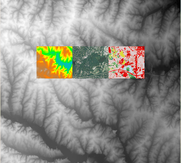
Figure: Downloaded NED (large and small extent), NAIP orthoimagery, and
NLCD land cover (NLCD is not available since 2020 through the API)
REFERENCES
TNM Access API
Guide
National Elevation Dataset
National Land Cover Dataset
SEE ALSO
g.region, r.import, r.patch, r.colors, r.in.srtm, v.in.pdal
AUTHORS
Zechariah Krautwurst, 2017 MGIST Candidate, North Carolina State
University
(initial version, Google Summer of Code 2017, mentors: Anna Petrasova,
Vaclav Petras)
Anna Petrasova, NCSU GeoForAll
Lab
Vaclav Petras, NCSU GeoForAll
Lab
SOURCE CODE
Available at: r.in.usgs source code
(history)
Latest change: Monday Jun 15 15:54:56 2026 in commit 9820d9a