r.soils.rosetta
Estimate van Genuchten soil hydraulic parameters from soil texture using the ROSETTA pedotransfer model.
r.soils.rosetta [-u] sand=name silt=name clay=name [bulk_density=name] [water_content_33=name] [water_content_1500=name] [version=integer] [theta_r=name] [theta_s=name] [alpha=name] [n=name] [ksat=name] [ksat_units=string] [--overwrite] [--verbose] [--quiet] [--qq] [--ui]
Example:
r.soils.rosetta sand=name silt=name clay=name
grass.tools.Tools.r_soils_rosetta(sand, silt, clay, bulk_density=None, water_content_33=None, water_content_1500=None, version=3, theta_r=None, theta_s=None, alpha=None, n=None, ksat=None, ksat_units="mm_per_hour", flags=None, overwrite=None, verbose=None, quiet=None, superquiet=None)
Example:
tools = Tools()
tools.r_soils_rosetta(sand="name", silt="name", clay="name")
This grass.tools API is experimental in version 8.5 and expected to be stable in version 8.6.
grass.script.run_command("r.soils.rosetta", sand, silt, clay, bulk_density=None, water_content_33=None, water_content_1500=None, version=3, theta_r=None, theta_s=None, alpha=None, n=None, ksat=None, ksat_units="mm_per_hour", flags=None, overwrite=None, verbose=None, quiet=None, superquiet=None)
Example:
gs.run_command("r.soils.rosetta", sand="name", silt="name", clay="name")
Parameters
sand=name [required]
Sand content raster map [percent, 0-100]
silt=name [required]
Silt content raster map [percent, 0-100]
clay=name [required]
Clay content raster map [percent, 0-100]
bulk_density=name
Bulk density raster map [g/cm3] (enables ROSETTA model 3)
water_content_33=name
Volumetric water content at 33 kPa raster map [cm3/cm3] (enables ROSETTA model 4)
water_content_1500=name
Volumetric water content at 1500 kPa raster map [cm3/cm3] (enables ROSETTA model 5)
version=integer
ROSETTA model calibration version (3 = Zhang and Schaap 2017)
Allowed values: 1, 2, 3
Default: 3
theta_r=name
Output residual water content raster map [cm3/cm3]
theta_s=name
Output saturated water content raster map [cm3/cm3]
alpha=name
Output van Genuchten alpha raster map [1/cm]
n=name
Output van Genuchten n raster map [dimensionless]
ksat=name
Output saturated hydraulic conductivity raster map
ksat_units=string
Units for the ksat output map
Allowed values: mm_per_hour, cm_per_day
Default: mm_per_hour
-u
Also write per-parameter uncertainty (standard deviation) maps as <output>_stddev
--overwrite
Allow output files to overwrite existing files
--help
Print usage summary
--verbose
Verbose module output
--quiet
Quiet module output
--qq
Very quiet module output
--ui
Force launching GUI dialog
sand : str | np.ndarray, required
Sand content raster map [percent, 0-100]
Used as: input, raster, name
silt : str | np.ndarray, required
Silt content raster map [percent, 0-100]
Used as: input, raster, name
clay : str | np.ndarray, required
Clay content raster map [percent, 0-100]
Used as: input, raster, name
bulk_density : str | np.ndarray, optional
Bulk density raster map [g/cm3] (enables ROSETTA model 3)
Used as: input, raster, name
water_content_33 : str | np.ndarray, optional
Volumetric water content at 33 kPa raster map [cm3/cm3] (enables ROSETTA model 4)
Used as: input, raster, name
water_content_1500 : str | np.ndarray, optional
Volumetric water content at 1500 kPa raster map [cm3/cm3] (enables ROSETTA model 5)
Used as: input, raster, name
version : int, optional
ROSETTA model calibration version (3 = Zhang and Schaap 2017)
Allowed values: 1, 2, 3
Default: 3
theta_r : str | type(np.ndarray) | type(np.array) | type(gs.array.array), optional
Output residual water content raster map [cm3/cm3]
Used as: output, raster, name
theta_s : str | type(np.ndarray) | type(np.array) | type(gs.array.array), optional
Output saturated water content raster map [cm3/cm3]
Used as: output, raster, name
alpha : str | type(np.ndarray) | type(np.array) | type(gs.array.array), optional
Output van Genuchten alpha raster map [1/cm]
Used as: output, raster, name
n : str | type(np.ndarray) | type(np.array) | type(gs.array.array), optional
Output van Genuchten n raster map [dimensionless]
Used as: output, raster, name
ksat : str | type(np.ndarray) | type(np.array) | type(gs.array.array), optional
Output saturated hydraulic conductivity raster map
Used as: output, raster, name
ksat_units : str, optional
Units for the ksat output map
Allowed values: mm_per_hour, cm_per_day
Default: mm_per_hour
flags : str, optional
Allowed values: u
u
Also write per-parameter uncertainty (standard deviation) maps as <output>_stddev
overwrite : bool, optional
Allow output files to overwrite existing files
Default: None
verbose : bool, optional
Verbose module output
Default: None
quiet : bool, optional
Quiet module output
Default: None
superquiet : bool, optional
Very quiet module output
Default: None
Returns:
result : grass.tools.support.ToolResult | np.ndarray | tuple[np.ndarray] | None
If the tool produces text as standard output, a ToolResult object will be returned. Otherwise, None will be returned. If an array type (e.g., np.ndarray) is used for one of the raster outputs, the result will be an array and will have the shape corresponding to the computational region. If an array type is used for more than one raster output, the result will be a tuple of arrays.
Raises:
grass.tools.ToolError: When the tool ended with an error.
sand : str, required
Sand content raster map [percent, 0-100]
Used as: input, raster, name
silt : str, required
Silt content raster map [percent, 0-100]
Used as: input, raster, name
clay : str, required
Clay content raster map [percent, 0-100]
Used as: input, raster, name
bulk_density : str, optional
Bulk density raster map [g/cm3] (enables ROSETTA model 3)
Used as: input, raster, name
water_content_33 : str, optional
Volumetric water content at 33 kPa raster map [cm3/cm3] (enables ROSETTA model 4)
Used as: input, raster, name
water_content_1500 : str, optional
Volumetric water content at 1500 kPa raster map [cm3/cm3] (enables ROSETTA model 5)
Used as: input, raster, name
version : int, optional
ROSETTA model calibration version (3 = Zhang and Schaap 2017)
Allowed values: 1, 2, 3
Default: 3
theta_r : str, optional
Output residual water content raster map [cm3/cm3]
Used as: output, raster, name
theta_s : str, optional
Output saturated water content raster map [cm3/cm3]
Used as: output, raster, name
alpha : str, optional
Output van Genuchten alpha raster map [1/cm]
Used as: output, raster, name
n : str, optional
Output van Genuchten n raster map [dimensionless]
Used as: output, raster, name
ksat : str, optional
Output saturated hydraulic conductivity raster map
Used as: output, raster, name
ksat_units : str, optional
Units for the ksat output map
Allowed values: mm_per_hour, cm_per_day
Default: mm_per_hour
flags : str, optional
Allowed values: u
u
Also write per-parameter uncertainty (standard deviation) maps as <output>_stddev
overwrite : bool, optional
Allow output files to overwrite existing files
Default: None
verbose : bool, optional
Verbose module output
Default: None
quiet : bool, optional
Quiet module output
Default: None
superquiet : bool, optional
Very quiet module output
Default: None
DESCRIPTION
r.soils.rosetta estimates Mualem-van Genuchten soil hydraulic parameters from soil texture using the ROSETTA pedotransfer model (Schaap et al. 2001; Zhang and Schaap 2017). It is a raster transform: given per-cell soil texture maps it predicts, for each cell, the residual water content (theta_r), saturated water content (theta_s), the van Genuchten alpha and n shape parameters, and the saturated hydraulic conductivity (ksat).
The required inputs are the USDA soil texture separates sand, silt, and clay, each as a percentage (0-100). Prediction accuracy increases as optional inputs are added, in this fixed order: bulk_density (g/cm3), water_content_33 (volumetric water content at 33 kPa, cm3/cm3), and water_content_1500 (volumetric water content at 1500 kPa, cm3/cm3). The set of supplied inputs selects the ROSETTA model automatically:
| Model | Inputs |
|---|---|
| 2 | sand, silt, clay |
| 3 | + bulk_density |
| 4 | + water_content_33 |
| 5 | + water_content_1500 |
Only the outputs you name are computed. The ksat map is written in mm/hr by default (ksat_units=mm_per_hour) so it can be used directly by hydrologic tools such as r.sim.water; set ksat_units=cm_per_day for ROSETTA's native units.
NOTES
The tool uses the offline
rosetta-soil Python package
(pip install rosetta-soil). When the package is not installed it falls back to
the handbook60.org ROSETTA web API, which
requires network access; the offline package is recommended for reproducible
runs. The uncertainty maps produced by the -u flag are only available with
the offline package.
ROSETTA reports alpha, n, and ksat as base-10 logarithms and ksat in cm/day; the tool back-transforms these to linear units and converts ksat to the requested units. The -u standard-deviation maps for alpha, n, and ksat remain in log10 space (the standard deviation of the log10 parameter), while theta_r and theta_s uncertainties are linear.
A cell is predicted only where every supplied input map has data; cells that are NULL in any input are NULL in all outputs. Because ROSETTA output depends only on the input tuple, the tool predicts each unique combination once, which makes it efficient on categorical inputs such as SSURGO map units.
ROSETTA is nonlinear, so applying it to depth-aggregated texture is not the same as aggregating hydraulic parameters computed per horizon. When driving the model from SSURGO map-unit texture (as in the workflow below), the texture has already been depth-weighted to a single value per map unit; interpret the result accordingly.
The tool respects the current computational region and mask and writes outputs to the current mapset.
EXAMPLES
Estimate hydraulic parameters from texture maps
g.region raster=sand -p
r.soils.rosetta sand=sand silt=silt clay=clay bulk_density=bd \
  theta_s=theta_s alpha=alpha n=n ksat=ksat version=3
Complete workflow: SSURGO to SIMWE
Import SSURGO with r.in.ssurgo, which writes depth-weighted texture and bulk-density rasters, estimate Ksat with r.soils.rosetta, then run overland flow with r.sim.water.
g.region raster=elevation -p

# Import SSURGO texture and bulk density for the top 25.4 cm.
r.in.ssurgo ssurgo_path=wss_SSA.zip soils=soils \
  sand=sand silt=silt clay=clay bulk_density=bd \
  hzdept_r=0 hzdepb_r=25.4

# Predict saturated hydraulic conductivity (mm/hr).
r.soils.rosetta sand=sand silt=silt clay=clay bulk_density=bd \
  ksat=ksat_vg version=3 ksat_units=mm_per_hour

# Partial derivatives of the surface for the flow solver.
r.slope.aspect elevation=elevation dx=dx dy=dy
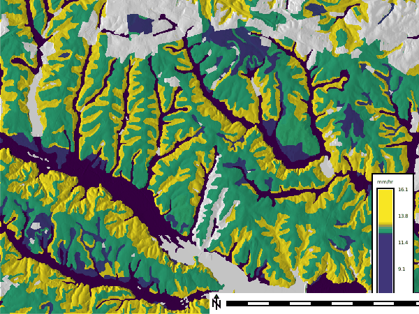
Figure: ROSETTA-estimated saturated hydraulic conductivity (mm/hr) from
SSURGO texture and bulk density over shaded relief (NC sample dataset, Lake
Wheeler area). Low-conductivity alluvial soils trace the drainage network;
gray areas are map units without soil data.
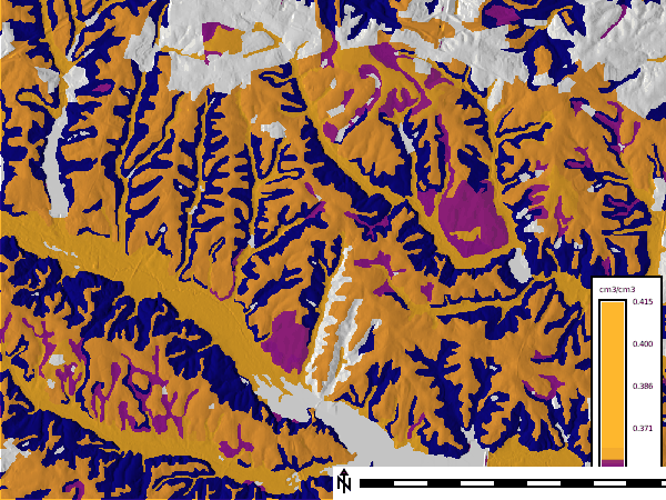
Figure: ROSETTA-estimated saturated water content theta_s (cm3/cm3) for the
same area.
Ksat then enters r.sim.water in one of two ways. Both interpret Ksat as the steady-state infiltration rate; do not use both at once or infiltration is counted twice.
Variant 1: supply Ksat as the infiltration loss on flowing water (infil):
r.sim.water elevation=elevation dx=dx dy=dy \
  rain_value=50 infil=ksat_vg man_value=0.1 \
  depth=depth discharge=discharge -t
Variant 2: fold Ksat into the rainfall excess (rain) and leave infil off. Rainfall excess is rainfall intensity minus infiltration, in mm/hr:
r.mapcalc "rain_excess = max(0.0, 50.0 - ksat_vg)"
r.sim.water elevation=elevation dx=dx dy=dy \
  rain=rain_excess man_value=0.1 \
  depth=depth discharge=discharge -t
REFERENCES
- Schaap, M.G., Leij, F.J., and van Genuchten, M.T. (2001). ROSETTA: a computer program for estimating soil hydraulic parameters with hierarchical pedotransfer functions. Journal of Hydrology 251(3-4): 163-176.
- Zhang, Y. and Schaap, M.G. (2017). Weighted recalibration of the Rosetta pedotransfer model with improved estimates of hydraulic parameter distributions and summary statistics (Rosetta3). Journal of Hydrology 547: 39-53.
SEE ALSO
r.in.ssurgo for importing SSURGO texture and Ksat, r.sim.water for overland flow simulation, r.slope.aspect for surface derivatives
AUTHORS
Corey T. White, Center for Geospatial Analytics, NC State University
SOURCE CODE
Available at: r.soils.rosetta source code
(history)
Latest change: Thursday Sep 03 04:43:28 2026 in commit 96c6e42