r.subdayprecip.design
Computes subday design precipitation totals.
r.subdayprecip.design map=name return_period=name [,name,...] rainlength=integer [area_size=float] [--verbose] [--quiet] [--qq] [--ui]
Example:
r.subdayprecip.design map=name return_period=name rainlength=0
grass.script.run_command("r.subdayprecip.design", map, return_period, rainlength, area_size=20, verbose=None, quiet=None, superquiet=None)
Example:
gs.run_command("r.subdayprecip.design", map="name", return_period="name", rainlength=0)
grass.tools.Tools.r_subdayprecip_design(map, return_period, rainlength, area_size=20, verbose=None, quiet=None, superquiet=None)
Example:
tools = Tools()
tools.r_subdayprecip_design(map="name", return_period="name", rainlength=0)
This grass.tools API is experimental in version 8.5 and expected to be stable in version 8.6.
Parameters
map=name [required]
Vector map of location under analysis
Or data source for direct OGR access
return_period=name [,name,...] [required]
Rainfall raster maps of required return period
rainlength=integer [required]
Design rainfall length in minutes
Allowed values: 0-1439
area_size=float
Maximum area size to be processed (in km2, -1 for no limit)
Default: 20
--help
Print usage summary
--verbose
Verbose module output
--quiet
Quiet module output
--qq
Very quiet module output
--ui
Force launching GUI dialog
map : str, required
Vector map of location under analysis
Or data source for direct OGR access
Used as: input, vector, name
return_period : str | list[str], required
Rainfall raster maps of required return period
Used as: input, raster, name
rainlength : int, required
Design rainfall length in minutes
Allowed values: 0-1439
area_size : float, optional
Maximum area size to be processed (in km2, -1 for no limit)
Default: 20
verbose : bool, optional
Verbose module output
Default: None
quiet : bool, optional
Quiet module output
Default: None
superquiet : bool, optional
Very quiet module output
Default: None
Returns:
result : grass.tools.support.ToolResult | None
If the tool produces text as standard output, a ToolResult object will be returned. Otherwise, None will be returned.
Raises:
grass.tools.ToolError: When the tool ended with an error.
DESCRIPTION
r.subdayprecip.design computes subday design precipitation totals based on Hradek's method of reduction of daily maximums to chosen duration.
The tool uses methods of zonal statistics to compute average values of 24 hours precipitation amounts of specified return period for a provided area or a spot. Rasters of daily maxima were derived from statistics published by Samaj et al. in 1985, which were based on precipitation series observed in 1901-1980. Calculated average value (in millimeters) is then reduced to the chosen length of design rain event.
NOTES
Subday design precipitation series are important for hydrological modelling and soil erosion problems in a small catchment scale when designing common measures for promoting water retention, landscape drainage systems, flood mitigation measures etc.
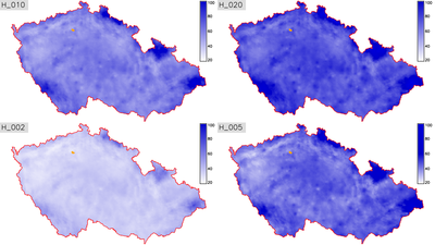
First automatization has been implemented by well-known method which is based on reduction of 24 hours design precipitation to shorter time. GIS can used for spatial supervised classification of point values of specified return periods (2, 10, 20, 50 and 100 years).

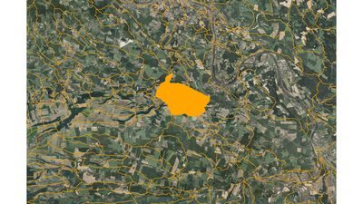
Figure: Basins (in orange) with orthophoto on background.

Figure: Return periods (2, 10, 20, 50 years) in the area of the Czech Republic.

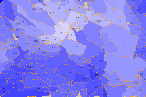
Figure: IV.order basins colored by mean H_N2T60 value (in
millimeters)
EXAMPLE
r.subdayprecip.design map=basin return_period=N2,N5,N10,N20 rainlength=60
REFERENCES
- Landa M., Kavka P., Strouhal L. (2015). A GIS tool for reduction day precipitation to subday (poster)
- Tomasu M. (2013). Tvorba nastoje pro sestaveni kratkodobych navrhovych destu na zaklade rizene interpolace a redukce (in Czech)
- Torfs, P. J. J. F., Horacek, S., & Rakovec, O. (2010). Chimera, a framework for conceptual modelling using analytical sensitives to parameters: implementation and application to PDM model.
- Sokol, Z., & Bliznak, V. (2009). Areal distribution and precipitation-altitude relationship of heavy short-term precipitation in the Czech Republic in the warm part of the year. Atmospheric Research, 94(4), 652-662.
Acknowledgement
This work has been supported by the research project QJ1520265 - "Variability of Short-term Precipitation and Runoff in Small Czech Drainage Basins and its Influence on Water Resources Management".
SEE ALSO
AUTHOR
Martin Landa, GeoForAll (OSGeoREL) Lab, Czech Technical University in
Prague, Czech Republic
The module is inspired by Python script developed for Esri ArcGIS
platform by M. Tomasu in 2013.
SOURCE CODE
Available at: r.subdayprecip.design source code
(history)
Latest change: Friday Feb 21 23:33:10 2025 in commit 7c35290