m.measure
Measures the lengths and areas of features.
m.measure [-g] coordinates=east,north [,east,north,...] [units=string] format=name [--verbose] [--quiet] [--qq] [--ui]
Example:
m.measure coordinates=0.0 format=plain
grass.tools.Tools.m_measure(coordinates, units=None, format="plain", flags=None, verbose=None, quiet=None, superquiet=None)
Example:
tools = Tools()
tools.m_measure(coordinates=0.0, format="json")
This grass.tools API is experimental in version 8.5 and expected to be stable in version 8.6.
grass.script.parse_command("m.measure", coordinates, units=None, format="plain", flags=None, verbose=None, quiet=None, superquiet=None)
Example:
gs.parse_command("m.measure", coordinates=0.0, format="json")
Parameters
coordinates=east,north [,east,north,...] [required]
Coordinates
units=string
Units
Default: project map units
Allowed values: miles, feet, meters, kilometers, acres, hectares
format=name [required]
Output format
Allowed values: plain, shell, json
Default: plain
plain: Plain text output
shell: shell script style output
json: JSON (JavaScript Object Notation)
-g
Shell script style [deprecated]
This flag is deprecated and will be removed in a future release. Use format=shell instead.
--help
Print usage summary
--verbose
Verbose module output
--quiet
Quiet module output
--qq
Very quiet module output
--ui
Force launching GUI dialog
coordinates : list[tuple[float, float]] | tuple[float, float] | list[float] | str, required
Coordinates
Used as: input, coords, east,north
units : str, optional
Units
Default: project map units
Allowed values: miles, feet, meters, kilometers, acres, hectares
format : str, required
Output format
Used as: name
Allowed values: plain, shell, json
plain: Plain text output
shell: shell script style output
json: JSON (JavaScript Object Notation)
Default: plain
flags : str, optional
Allowed values: g
g
Shell script style [deprecated]
This flag is deprecated and will be removed in a future release. Use format=shell instead.
verbose : bool, optional
Verbose module output
Default: None
quiet : bool, optional
Quiet module output
Default: None
superquiet : bool, optional
Very quiet module output
Default: None
Returns:
result : grass.tools.support.ToolResult | None
If the tool produces text as standard output, a ToolResult object will be returned. Otherwise, None will be returned.
Raises:
grass.tools.ToolError: When the tool ended with an error.
coordinates : list[tuple[float, float]] | tuple[float, float] | list[float] | str, required
Coordinates
Used as: input, coords, east,north
units : str, optional
Units
Default: project map units
Allowed values: miles, feet, meters, kilometers, acres, hectares
format : str, required
Output format
Used as: name
Allowed values: plain, shell, json
plain: Plain text output
shell: shell script style output
json: JSON (JavaScript Object Notation)
Default: plain
flags : str, optional
Allowed values: g
g
Shell script style [deprecated]
This flag is deprecated and will be removed in a future release. Use format=shell instead.
verbose : bool, optional
Verbose module output
Default: None
quiet : bool, optional
Quiet module output
Default: None
superquiet : bool, optional
Very quiet module output
Default: None
DESCRIPTION
m.measure provides the user with a way to measure the lengths and areas of lines and polygons. Areas can be stated in acres, hectares, square miles, square feet, square meters and square kilometers.
EXAMPLES
Distance example in a latitude-longitude coordinate reference system (on great circle, i.e. an orthodrome):
Bonn_DE="7.09549,50.73438"
Philadelphia_US="-75.16379,39.95233"

m.measure coordinates="$Bonn_DE,$Philadelphia_US" units=kilometers
Length:  6217.916452 kilometers
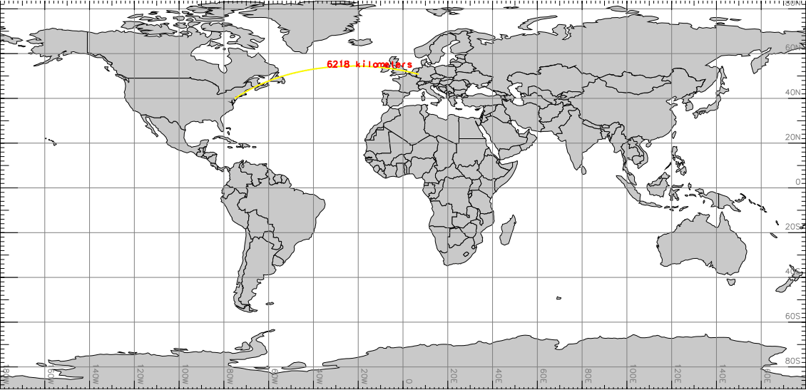
Visualization (with d.geodesic) of m.measure
distance example
As an example for the North Carolina sample dataset, here four points describing a square of 1000m side length:
m.measure units=meters \
  coordinates=922000,2106000,923000,2106000,923000,2107000,922000,2107000
Length:  3000.000000 meters
Area:    1000000.000000 square meters

# script style output:
m.measure -g units=hectares \
  coordinates=922000,2106000,923000,2106000,923000,2107000,922000,2107000
units=meters,square meters
length=3000.000000
area=1000000.000000
Measuring length and area using Python (JSON output):
import grass.script as gs

data = gs.parse_command(
    "m.measure",
    coordinates=[
        "922000",
        "2106000",
        "923000",
        "2106000",
        "923000",
        "2107000",
        "922000",
        "2107000",
    ],
    format="json",
)
print(data)
Possible output:
{'units': {'length': 'meters', 'area': 'square meters'}, 'length': 3000, 'area': 1000000}
SEE ALSO
AUTHORS
Glynn Clements
Some updates by Martin Landa, CTU in Prague, Czech Republic
Derived from d.measure by James Westervelt, Michael Shapiro, U.S. Army Construction Engineering Research Laboratory
SOURCE CODE
Available at: m.measure source code
(history)
Latest change: Monday Nov 03 07:16:48 2025 in commit c967967