r.li.mpa
Calculates mean pixel attribute index on a raster map
r.li.mpa input=name config=name output=name [--overwrite] [--verbose] [--quiet] [--qq] [--ui]
Example:
r.li.mpa input=name config=name output=name
grass.tools.Tools.r_li_mpa(input, config, output, overwrite=None, verbose=None, quiet=None, superquiet=None)
Example:
tools = Tools()
tools.r_li_mpa(input="name", config="name", output="name")
This grass.tools API is experimental in version 8.5 and expected to be stable in version 8.6.
grass.script.run_command("r.li.mpa", input, config, output, overwrite=None, verbose=None, quiet=None, superquiet=None)
Example:
gs.run_command("r.li.mpa", input="name", config="name", output="name")
Parameters
input=name [required]
Name of input raster map
config=name [required]
Configuration file
output=name [required]
Name for output raster map
--overwrite
Allow output files to overwrite existing files
--help
Print usage summary
--verbose
Verbose module output
--quiet
Quiet module output
--qq
Very quiet module output
--ui
Force launching GUI dialog
input : str | np.ndarray, required
Name of input raster map
Used as: input, raster, name
config : str | io.StringIO, required
Configuration file
Used as: input, file, name
output : str | type(np.ndarray) | type(np.array) | type(gs.array.array), required
Name for output raster map
Used as: output, raster, name
overwrite : bool, optional
Allow output files to overwrite existing files
Default: None
verbose : bool, optional
Verbose module output
Default: None
quiet : bool, optional
Quiet module output
Default: None
superquiet : bool, optional
Very quiet module output
Default: None
Returns:
result : grass.tools.support.ToolResult | np.ndarray | tuple[np.ndarray] | None
If the tool produces text as standard output, a ToolResult object will be returned. Otherwise, None will be returned. If an array type (e.g., np.ndarray) is used for one of the raster outputs, the result will be an array and will have the shape corresponding to the computational region. If an array type is used for more than one raster output, the result will be a tuple of arrays.
Raises:
grass.tools.ToolError: When the tool ended with an error.
input : str, required
Name of input raster map
Used as: input, raster, name
config : str, required
Configuration file
Used as: input, file, name
output : str, required
Name for output raster map
Used as: output, raster, name
overwrite : bool, optional
Allow output files to overwrite existing files
Default: None
verbose : bool, optional
Verbose module output
Default: None
quiet : bool, optional
Quiet module output
Default: None
superquiet : bool, optional
Very quiet module output
Default: None
DESCRIPTION
r.li.mpa (mean pixel attribute) calculates the average value of the
attribute of all the non-null cells in the sampling area as:
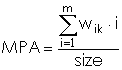
with:
- i: attribute
- m: number of non-null attributes in the sampling area
- w_i: number of cells of attribute i
- size: size of sampling area (in cells)
NOTES
Do not use absolute path names for the config and output
file/map parameters. If the "moving window" method was selected in
g.gui.rlisetup, then the output will be a raster map, otherwise an
ASCII file will be generated in the folder
C:\Users\userxy\AppData\Roaming\GRASS8\r.li\output\ (MS-Windows) or
$HOME/.grass8/r.li/output/ (GNU/Linux).
If the input raster map contains only NULL values then r.li.mpa
considers to have 0 patches.
If area is 0 r.li.mpa returns -1; it is possible only if the raster is
masked
If you want to change these -1 values to NULL, run subsequently on the
resulting map:
r.null setnull=-1 input=my_map
after index calculation.
EXAMPLES
To calculate the mean pixel attribute index on map my_map, using my_conf configuration file (previously defined with g.gui.rlisetup) and saving results in my_out, run:
r.li.mpa input=my_map conf=my_conf output=my_out
Forest map (Spearfish sample dataset) example:
g.region raster=landcover.30m -p
r.mapcalc "forests = if(landcover.30m >= 41 && landcover.30m <= 43,1,null())"
r.li.mpa input=forests conf=movwindow7 out=forests_mpa_mov7
r.univar forests_mpa_mov7
Forest map (North Carolina sample dataset) example:
g.region raster=landclass96 -p
r.mapcalc "forests = if(landclass96 == 5, 1, null() )"
r.li.mpa input=forests conf=movwindow7 out=forests_mpa_mov7

# verify
r.univar forests_mpa_mov7
r.to.vect input=forests output=forests type=area
d.mon wx0
d.rast forests_mpa_mov7
d.vect forests type=boundary
SEE ALSO
r.li (package overview), g.gui.rlisetup
REFERENCES
McGarigal, K., and B. J. Marks. 1995. FRAGSTATS: spatial pattern analysis program for quantifying landscape structure. USDA For. Serv. Gen. Tech. Rep. PNW-351. (PDF)
AUTHORS
Serena Pallecchi, student of Computer Science University of Pisa
(Italy).
Commission from Faunalia Pontedera (PI), Italy (
Markus Metz
SOURCE CODE
Available at: r.li.mpa source code
(history)
Latest change: Friday Apr 17 01:04:26 2026 in commit 5a31d54