v.fill.holes
Fill holes in areas by keeping only outer boundaries
v.fill.holes input=name [layer=string] [cats=range] [where=sql_query] output=name [--overwrite] [--verbose] [--quiet] [--qq] [--ui]
Example:
v.fill.holes input=name output=name
grass.tools.Tools.v_fill_holes(input, layer="1", cats=None, where=None, output, overwrite=None, verbose=None, quiet=None, superquiet=None)
Example:
tools = Tools()
tools.v_fill_holes(input="name", output="name")
This grass.tools API is experimental in version 8.5 and expected to be stable in version 8.6.
grass.script.run_command("v.fill.holes", input, layer="1", cats=None, where=None, output, overwrite=None, verbose=None, quiet=None, superquiet=None)
Example:
gs.run_command("v.fill.holes", input="name", output="name")
Parameters
input=name [required]
Name of input vector map
Or data source for direct OGR access
layer=string
Layer number or name
Vector features can have category values in different layers. This number determines which layer to use. When used with direct OGR access this is the layer name.
Default: 1
cats=range
Category values
Example: 1,3,7-9,13
where=sql_query
WHERE conditions of SQL statement without 'where' keyword
Example: income < 1000 and population >= 10000
output=name [required]
Name for output vector map
--overwrite
Allow output files to overwrite existing files
--help
Print usage summary
--verbose
Verbose module output
--quiet
Quiet module output
--qq
Very quiet module output
--ui
Force launching GUI dialog
input : str, required
Name of input vector map
Or data source for direct OGR access
Used as: input, vector, name
layer : str, optional
Layer number or name
Vector features can have category values in different layers. This number determines which layer to use. When used with direct OGR access this is the layer name.
Used as: input, layer
Default: 1
cats : str, optional
Category values
Example: 1,3,7-9,13
Used as: input, cats, range
where : str, optional
WHERE conditions of SQL statement without 'where' keyword
Example: income < 1000 and population >= 10000
Used as: input, sql_query, sql_query
output : str, required
Name for output vector map
Used as: output, vector, name
overwrite : bool, optional
Allow output files to overwrite existing files
Default: None
verbose : bool, optional
Verbose module output
Default: None
quiet : bool, optional
Quiet module output
Default: None
superquiet : bool, optional
Very quiet module output
Default: None
Returns:
result : grass.tools.support.ToolResult | None
If the tool produces text as standard output, a ToolResult object will be returned. Otherwise, None will be returned.
Raises:
grass.tools.ToolError: When the tool ended with an error.
input : str, required
Name of input vector map
Or data source for direct OGR access
Used as: input, vector, name
layer : str, optional
Layer number or name
Vector features can have category values in different layers. This number determines which layer to use. When used with direct OGR access this is the layer name.
Used as: input, layer
Default: 1
cats : str, optional
Category values
Example: 1,3,7-9,13
Used as: input, cats, range
where : str, optional
WHERE conditions of SQL statement without 'where' keyword
Example: income < 1000 and population >= 10000
Used as: input, sql_query, sql_query
output : str, required
Name for output vector map
Used as: output, vector, name
overwrite : bool, optional
Allow output files to overwrite existing files
Default: None
verbose : bool, optional
Verbose module output
Default: None
quiet : bool, optional
Quiet module output
Default: None
superquiet : bool, optional
Very quiet module output
Default: None
DESCRIPTION
v.fill.holes fills empty spaces inside areas, specifically it preserves areas with centroids while areas without centroids, which typically represent holes, are removed. v.fill.holes goes over all areas in a vector map and it preserves only outer boundaries of each area while removing inner boundaries which are considered holes. The holes become part of the area which contained them. No boundaries of these holes are preserved.
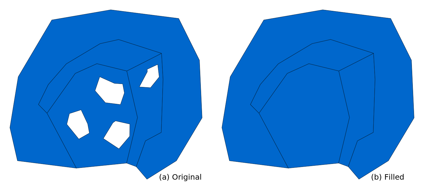
Figure: Holes inside areas are removed. (a) Original areas with holes
and (b) the same areas but with holes filled.
In case areas have empty space in between them, i.e., there are holes in the overall coverage, but not in the areas themselves, v.fill.holes can't assign this empty space to either of these areas because it does not know which area this empty space should belong to. If the space needs to be filled, this can be resolved by merging the areas around the empty space into one by dissolving their common boundaries. This turns the empty space into a hole inside one single area which turns the situation into a case of one area with a hole.
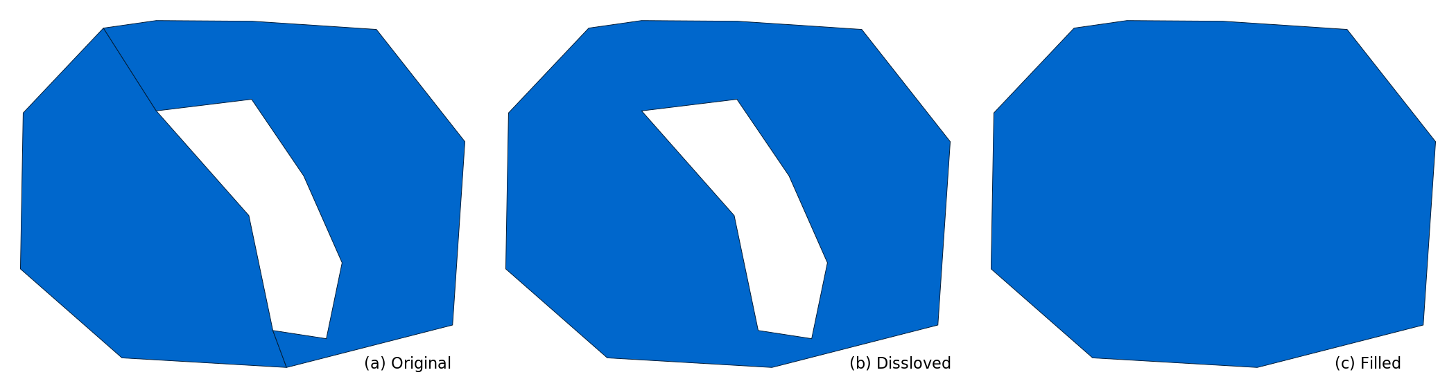
Figure: Empty space in between two areas does not belong to either
area, so it is filled only after the boundaries between areas are
dissolved, i.e., areas merged into one. (a) Original areas with space in
between, (b) one area with a hole after dissolving the common boundary,
and (c) hole filled.
Topology
Strictly speaking, in the GRASS topological model, an area is a closed boundary (or a series of connected closed boundaries) which may have a centroid. If it has a centroid, it is rendered as a filled area in displays and this is what is usually considered an area from the user perspective. These are the areas where v.fill.holes preserves the associated outer boundary (or boundaries). Other closed boundaries, i.e., those without a centroid, are not carried over to the output. All other features are removed including points and lines.
Attributes
If a specific layer is selected, attributes for that layer are preserved for the areas based on the category or categories associated with each area. By default, layer number 1 is selected. In case there are attribute tables associated with other layers or attributes associated with categories of other features than areas with centroids, this attribute data is not carried over to the output just like the corresponding geometries.
EXAMPLE
The lakes vector map in the North Carolina sample dataset represents islands inside lakes as areas distinguished by attributes. To demonstrate v.fill.holes, we will first extract only the lakes which will create holes where the islands were located. Then, we will fill the holes created in the lakes to get the whole perimeter of the lakes including islands. Remove the islands by extracting everything else (results in holes):
v.extract input=lakes where="FTYPE != 'ROCK/ISLAND'" output=lakes_only
Remove the holes:
v.fill.holes input=lakes_only output=lakes_filled
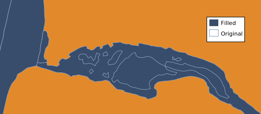
Figure: The filled lake (blue) and borders of the original lakes with
islands removed (light blue). Figure shows a smaller area in the north
of the data extent.
SEE ALSO
- v.dissolve for removing common boundaries based on attributes,
- v.clean for removing topological issues,
- r.fillnulls for filling empty spaces in raster maps using interpolation,
- r.fill.stats for filling empty spaces in raster maps using statistics.
AUTHOR
Vaclav Petras, NCSU Center for Geospatial Analytics, GeoForAll Lab
SOURCE CODE
Available at: v.fill.holes source code
(history)
Latest change: Friday Jun 20 15:13:04 2025 in commit 9dd92f9