i.sentinel.preproc
Imports and performs atmospheric correction of Sentinel-2 images.
i.sentinel.preproc [-atriclo] input_dir=name elevation=name [visibility=name] atmospheric_model=string aerosol_model=string [aod_value=string] [aeronet_file=name] suffix=string [rescale=min,max] [text_file=name] [topo_method=string] [topo_prefix=string] [memory=integer] [--overwrite] [--verbose] [--quiet] [--qq] [--ui]
Example:
i.sentinel.preproc input_dir=name elevation=name atmospheric_model=Automatic aerosol_model=Continental model aod_value=string suffix=string
grass.tools.Tools.i_sentinel_preproc(input_dir, elevation, visibility=None, atmospheric_model="Automatic", aerosol_model="Continental model", aod_value=None, aeronet_file=None, suffix, rescale="0,1", text_file=None, topo_method=None, topo_prefix="tcor", memory=300, flags=None, overwrite=None, verbose=None, quiet=None, superquiet=None)
Example:
tools = Tools()
tools.i_sentinel_preproc(input_dir="name", elevation="name", atmospheric_model="Automatic", aerosol_model="Continental model", aod_value="string", suffix="string")
This grass.tools API is experimental in version 8.5 and expected to be stable in version 8.6.
grass.script.run_command("i.sentinel.preproc", input_dir, elevation, visibility=None, atmospheric_model="Automatic", aerosol_model="Continental model", aod_value=None, aeronet_file=None, suffix, rescale="0,1", text_file=None, topo_method=None, topo_prefix="tcor", memory=300, flags=None, overwrite=None, verbose=None, quiet=None, superquiet=None)
Example:
gs.run_command("i.sentinel.preproc", input_dir="name", elevation="name", atmospheric_model="Automatic", aerosol_model="Continental model", aod_value="string", suffix="string")
Parameters
input_dir=name [required]
Name of the directory where the image and metadata file are stored (*.SAFE)
elevation=name [required]
Name of input elevation raster map
visibility=name
Name of input visibility raster map (in m)
atmospheric_model=string [required]
Select the proper Atmospheric model
Allowed values: Automatic, No gaseous absorption, Tropical, Midlatitude summer, Midlatitude winter, Subarctic summer, Subarctic winter, Us standard 62
Default: Automatic
aerosol_model=string [required]
Select the proper Aerosol model
Allowed values: No aerosols, Continental model, Maritime model, Urban model, Shettle model for background desert aerosol, Biomass burning, Stratospheric model
Default: Continental model
aod_value=string
AOD value at 550nm
aeronet_file=name
Name of the AERONET file for computing AOD at 550nm
suffix=string [required]
Suffix for output raster maps
rescale=min,max
Rescale output raster map
Default: 0,1
text_file=name
Name for output text file to be used as input in i.sentinel.mask
topo_method=string
Topographic correction method
Allowed values: cosine, minnaert, c-factor, percent
topo_prefix=string
Prefix for topographic corrected images
Default: tcor
memory=integer
Maximum memory to be used (in MB)
Cache size for raster rows
Default: 300
-a
Use AOD instead visibility
-t
Create the input text file for i.sentinel.mask
-r
Reproject raster data using r.import if needed
-i
Skip import of Sentinel bands
-c
Computes topographic correction of reflectance
-l
Link raster data instead of importing
-o
Override projection check (use current location's projection)
--overwrite
Allow output files to overwrite existing files
--help
Print usage summary
--verbose
Verbose module output
--quiet
Quiet module output
--qq
Very quiet module output
--ui
Force launching GUI dialog
input_dir : str, required
Name of the directory where the image and metadata file are stored (*.SAFE)
Used as: input, dir, name
elevation : str | np.ndarray, required
Name of input elevation raster map
Used as: input, raster, name
visibility : str | np.ndarray, optional
Name of input visibility raster map (in m)
Used as: input, raster, name
atmospheric_model : str, required
Select the proper Atmospheric model
Allowed values: Automatic, No gaseous absorption, Tropical, Midlatitude summer, Midlatitude winter, Subarctic summer, Subarctic winter, Us standard 62
Default: Automatic
aerosol_model : str, required
Select the proper Aerosol model
Allowed values: No aerosols, Continental model, Maritime model, Urban model, Shettle model for background desert aerosol, Biomass burning, Stratospheric model
Default: Continental model
aod_value : str, optional
AOD value at 550nm
aeronet_file : str | io.StringIO, optional
Name of the AERONET file for computing AOD at 550nm
Used as: input, file, name
suffix : str, required
Suffix for output raster maps
rescale : tuple[str, str] | list[str] | str, optional
Rescale output raster map
Used as: min,max
Default: 0,1
text_file : str, optional
Name for output text file to be used as input in i.sentinel.mask
Used as: output, file, name
topo_method : str, optional
Topographic correction method
Allowed values: cosine, minnaert, c-factor, percent
topo_prefix : str, optional
Prefix for topographic corrected images
Default: tcor
memory : int, optional
Maximum memory to be used (in MB)
Cache size for raster rows
Default: 300
flags : str, optional
Allowed values: a, t, r, i, c, l, o
a
Use AOD instead visibility
t
Create the input text file for i.sentinel.mask
r
Reproject raster data using r.import if needed
i
Skip import of Sentinel bands
c
Computes topographic correction of reflectance
l
Link raster data instead of importing
o
Override projection check (use current location's projection)
overwrite : bool, optional
Allow output files to overwrite existing files
Default: None
verbose : bool, optional
Verbose module output
Default: None
quiet : bool, optional
Quiet module output
Default: None
superquiet : bool, optional
Very quiet module output
Default: None
Returns:
result : grass.tools.support.ToolResult | None
If the tool produces text as standard output, a ToolResult object will be returned. Otherwise, None will be returned.
Raises:
grass.tools.ToolError: When the tool ended with an error.
input_dir : str, required
Name of the directory where the image and metadata file are stored (*.SAFE)
Used as: input, dir, name
elevation : str, required
Name of input elevation raster map
Used as: input, raster, name
visibility : str, optional
Name of input visibility raster map (in m)
Used as: input, raster, name
atmospheric_model : str, required
Select the proper Atmospheric model
Allowed values: Automatic, No gaseous absorption, Tropical, Midlatitude summer, Midlatitude winter, Subarctic summer, Subarctic winter, Us standard 62
Default: Automatic
aerosol_model : str, required
Select the proper Aerosol model
Allowed values: No aerosols, Continental model, Maritime model, Urban model, Shettle model for background desert aerosol, Biomass burning, Stratospheric model
Default: Continental model
aod_value : str, optional
AOD value at 550nm
aeronet_file : str, optional
Name of the AERONET file for computing AOD at 550nm
Used as: input, file, name
suffix : str, required
Suffix for output raster maps
rescale : tuple[str, str] | list[str] | str, optional
Rescale output raster map
Used as: min,max
Default: 0,1
text_file : str, optional
Name for output text file to be used as input in i.sentinel.mask
Used as: output, file, name
topo_method : str, optional
Topographic correction method
Allowed values: cosine, minnaert, c-factor, percent
topo_prefix : str, optional
Prefix for topographic corrected images
Default: tcor
memory : int, optional
Maximum memory to be used (in MB)
Cache size for raster rows
Default: 300
flags : str, optional
Allowed values: a, t, r, i, c, l, o
a
Use AOD instead visibility
t
Create the input text file for i.sentinel.mask
r
Reproject raster data using r.import if needed
i
Skip import of Sentinel bands
c
Computes topographic correction of reflectance
l
Link raster data instead of importing
o
Override projection check (use current location's projection)
overwrite : bool, optional
Allow output files to overwrite existing files
Default: None
verbose : bool, optional
Verbose module output
Default: None
quiet : bool, optional
Quiet module output
Default: None
superquiet : bool, optional
Very quiet module output
Default: None
DESCRIPTION
i.sentinel.preproc allows to import Sentinel-2 images and perform atmospheric and topographic correction.
i.sentinel.preproc is a module for the preprocessing of Sentinel-2
images (Level-1C Single Tile product) which wraps the import, the
atmospheric and the topographic correction using respectively
i.sentinel.import,
i.atcorr
and
i.topo.corr.
It works both with Sentinel-2A and 2B images.
The aim is to provide a simplified module which allows importing images,
which area downloaded using
i.sentinel.download or any other sources, and
performing the atmospheric correction avoiding users to provide all the
required input parameters manually. In fact, regarding the atmospheric
correction performed with i.atcorr one of the most challenging steps,
especially for unexperienced users, is the compiling of the control file
with all the required parameters to parametrize the 6S (Second
Simulation of Satellite Signal in the Solar Spectrum) model on which
i.atcorr is based.
To run i.atcorr, users have to provide the so-called control file in
which all the parameters (geometrical conditions, date, time, longitude
and latitude of the center of the scene, atmospheric model, aerosol
model, visibility or Aerosol Optical Depth -AOD- value, mean elevation
target and bands number) have to be specified with precise syntax rules
and codes.
i.sentinel.preproc retrieves as many parameters as possible from the
metadata file (e.g. Geometrical conditions, data and time and bands
number), longitude and latitude are automatically computed from the
computational region while others like the mean target elevation above
sea level from the input digital elevation model (DEM). Only a few
parameters have to be provided by users who can choose the proper option
from a drop-down menu thus avoiding to enter the corresponding code. In
any case, i.sentinel.preproc writes a temporary control file, changing
it according to the band number, following the syntax rules and codes of
i.atcorr and then it runs i.atcorr for all bands. Using the c flag
i.sentinel.preproc is able to perform also the topographic correction
using
i.topo.corr
creating the needed information as the illumination model based on the
elevation model provided by the user.
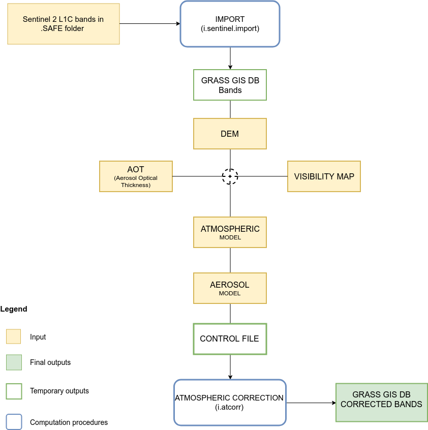
Fig: Module General WorkFlow
When all bands have been processed by the integrated version of i.atcorr, an histogram equalization grayscale color scheme is applied.
If the -t flag is set, a text file ready to be used as input for i.sentinel.mask will be created. In this case a name for the output text file has to be specified.
NOTE: as for i.atcorr, current region settings are ignored. The region is temporary set to maximum image extent and restored at the end of the process.
Important: i.sentinel.preproc requires all the bands of a
Sentinel-2 images. If the module is used only for the atmospheric
correction, all bands from *_B01 to *_B12 must be imported.
Moreover, the original bands name has to be kept unchanged (e.g if the
original name is T17SPV_20180315T160021_B02 the imported raster map
in the GIS DATABSE must be named T17SPV_20180315T160021_B02).
Import
i.sentinel.preproc allows the import of all the bands of a Sentinel-2
image. The required input is the .SAFE folder downloaded using
i.sentinel.download or any other source (e.g. Copernicus Open Access
Hub). Note that in the case that spatial reference system of input data
differs from GRASS location, the input data are reprojected.
The number of imported bands can not be reduced, all bands are
automatically imported by default.
Important: i.sentinel.preproc allows the import of one image at a time because the input .SAFE folder is also used to automatically identify the corresponding metadata file that is used during the atmospheric correction.
The import can be skipped using the -i flag. Note that even if the import is skipped the input .SAFE folder must be specified to automatically retrieve the metadata file.
Atmospheric correction
i.sentinel.preproc allows performing atmospheric correction of all bands of a Sentinel-2 scene with a single process using i.atcorr. Unlike i.atcorr, it writes the control file changing it according to the band number. The only required inputs are:
- input_dir = the *.SAFE directory where the image and metadata file (MTD_MSIL1C.xml or S2A_OPER_MTD_SAFL1C_PDMC_*.xml depending on naming convention) are stored,
- elevation = raster of a digital elevation model,
- visibility or AOD value = raster of a visibility map or an AOD value (see AOD section),
- Atmospheric model = to be choosen from the drop-down menu,
- Aerosol model = to be choosen from the drop-down menu,
- suffix = a suffix for the output maps name
- rescale = the output range of values for the corrected bands, for example: 0-255, 0-1, 1-10000 (default value 0-1).
The module writes the control file automatically starting from the input above.
Control file
i.atcorr requires a control file to parametrize the 6S algorithm on which it is based.
Below an example of the control file, taken from the i.atcorr manual page, of a Sentinel-2A image:
25                            - geometrical conditions = Sentinel-2A
5 4 19.737 -78.727 35.748     - month day hh.ddd longitude latitude ("hh.ddd" is in decimal hours GMT)
2                             - atmospheric model = midlatitude summer
1                             - aerosols model = continental
0                             - visibility [km] (aerosol model concentration)
0.07                          - AOD at 550nm
-0.124                        - mean target elevation above sea level [km]
-1000                         - sensor height (here, sensor on board a satellite)
167                           - sensor band = Sentinel2A Blue band B2
Using i.sentinel.preproc the only parameters from the list above that users have to provide are: atmospheric model, aerosol model, visibility or AOD value. The others are automatically retrieved from the metadata file, input elevation map and bands.
-
Geometrical conditions
The geometrical condition of the satellite are read from the metadata file and converted to the corresponding i.atcorr code, 25 for Sentinel-2A mission and 26 for Sentinel-2B.
-
Date, time, longitude and latitude
Date (month and day) and time are read from the metadata file. The date (with the format YYYY-MM-DDTHH:MM:SSZ) is converted in a standard format and only the month and the day are selected and added to the control file.
Time is already in Greenwich Mean Time (GMT), as i.atcorr requires, and it's automatically converted to decimal hours.
Longitude and latitude are computed from the computational region and converted to WGS84 decimal coordinates. -
Atmospheric model
Only some options are available:
- Automatic
- No gaseous absorption
- Tropical
- Midlatitude summer
- Midlatitude winter
- Subarctic summer
- Subarctic winter
- Us standard 62
Users can choose the proper option from a drop-down menu. The desired model is automatically converted to the corresponding code and added to the control file.
Automatic option
The default option is Automatic which consists in the automatic identification of the proper atmospheric model for the input image. The Automatic option reads the latitude of the center of the computational region and uses it to choose between Midlatitude (15.00 > lat \<= 45.00), Tropical (-15.00 > lat \<= 15.00) and Subarctic (45.00 > lat \<= 60.00) for Northern Hemisphere (obviously it also works for the Southern Hemisphere). Then, the month from the acquisition date is used to distinguish summer or winter in case of Midlatitude or Subarctic model. Once the proper atmospheric model is identified, it is converted to the corresponding code and added to the control file.
Note that this is a simplified and standardized method to identify the atmospheric model. Obviously, it is possible to choose other options from those available. -
Aerosol model
Also in this case, only some options are available and users have to select the desired one from the drop-down menu, then it is converted to the corresponding code and added to the control file.
- no aerosols
- continental model
- maritime model
- urban model
- shettle model for background desert aerosol
- biomass burning
- stratospheric model
No automatic procedure has been implemented in this case.
-
Visibility or AOD
By default, i.sentinel.preproc uses the input visibility map to estimate a visibility value to be added in the control file. If no visibility map is available for the processed scene, it is possible to use an estimated Aerosol Optical Depth (AOD) value checking the -a flag.
If the -a flag is checked and a visibility map is provided, the visibility will be ignored and no mean visibility value will be computed and added to the control file. Whereas, if the -a flag isn't checked and an AOD value is provided it will be ignored and not added to the control file.In the same way, if the -a flag is checked and a visibility map is provided it will be excluded from atmospheric correction process.
AOD
The AOD value can be specified by users (e.g.
aod_value=0.07) or automatically retrieved from an AERONET file to be given as input instead of the AOD value.
i.sentinel.preproc reads the AERONET file, identify the closest available date to the scene date and compute AOD at 550nm using the closest upper and lower wavelength to 550 (e.g. 500nm and 675nm) and applying the Angstrom coefficient.The type of AERONET file is a Combined file for All Points (Level 1.5 or 2.0)
To download this kind of file:- Go to https://aeronet.gsfc.nasa.gov/cgi-bin/webtool_opera_v2_inv
- Choose the site you want to get data from
- Choose the data you want to get data for
- Tick the box near the bottom labelled as 'Combined file (all products without phase functions)'
- Choose either Level 1.5 or Level 2.0 data. Level 1.5 data is unscreened, so contains far more data meaning it is more likely for users to find data near your specified time
- Choose 'All Points' under Data Format
- Download the file
- Unzip (the file has a .dubovik extension)
Then, giving this file as input (e.g.
aeronet_file=your_path/*.dubovik), the AOD at 550nm will be automatically computed and added to the control file.NOTE: as in i.atcorr manual explained, if an AOD value is provided a value 0 for the visibility has to be entered with the AOD value in the following line. Obviously, i.sentinel.preproc takes into account this syntax rule and automatically adds a 0 value for visibility (or -1 if AOD=0) if an AOD value is provided (through both
aod_valueandaeronet_file). -
Mean target elevation above sea level
Mean target elevation above sea level is automatically estimated from the input digital elevation model. According to the rules for writing the contol file of i.atcorr, the mean elevation value is added as a negative value and converted in kilometers (e.g. if mean=121 in the control file it will be written in [-km], i.e., -0.121).
-
Sensor height
Since the sensor is on board a satellite, the sensor height is automatically set to -1000.
-
Sensor band
The number of the band changes automatically according to the band that is processed at that moment. The module reads the name of the band and converts it into the corresponding code.
Topographic correction
i.sentinel.preproc allows performing the topographic correction of all bands of a Sentinel-2 scene with a single process using i.topo.corr. i.sentinel.preproc calculate the zenit and azimuth angles using r.sunmask, after that it create the illumination model based on the elevation model and apply it to all the bands of a Sentinel-2 scene
EXAMPLE
The example illustrates how to run i.sentinel.preproc for a
Sentinel-2A image
(S2A_MSIL1C_20180315T160021_N0206_R097_T17SPV_20180315T194425.SAFE)
in the North Carolina location.
The AERONET file has been downloaded from the EPA-Res_Triangle_Pk
station.
i.sentinel.preproc -a -t input_dir=/path/S2A_MSIL1C_20180315T160021_N0206_R097_T17SPV_20180315T194425.SAFE \
  elevation=elevation atmospheric_model=Automatic aerosol_model="Continental model" \
  aeronet_file=path/180301_180331_EPA-Res_Triangle_Pk.dubovik suffix=cor text_file=/path/input_cloud_mask.txt
Here is the control file automatically written for Band 02 of the input scene
25
5 4 19.74 -78.728 35.749
3                           -The Automatic option identified the Midlatitude Winter as the proper model for the scene
1
0                           -The visibility is set to 0 with AOD in the following line
0.18867992317               -AOD computed from the input AERONET file
-0.122
-1000
167
Here is the output text file ready to be used as input for i.sentinel.mask (-t flag)
blue=T17SPV_20180315T160021_B02_cor
green=T17SPV_20180315T160021_B03_cor
red=T17SPV_20180315T160021_B04_cor
swir11=T17SPV_20180315T160021_B11_cor
nir=T17SPV_20180315T160021_B08_cor
swir12=T17SPV_20180315T160021_B12_cor
nir8a=T17SPV_20180315T160021_B8A_cor
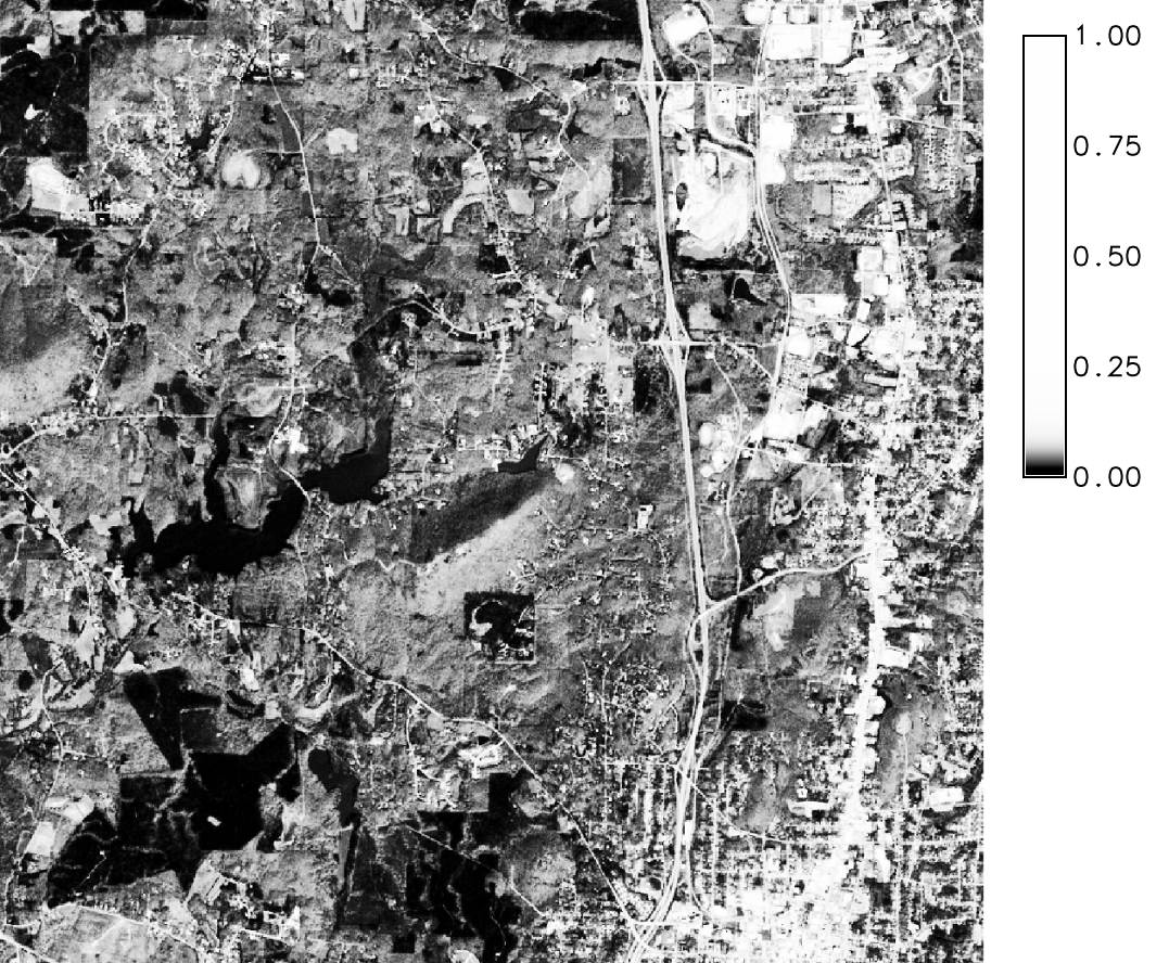
Figure: Sentinel-2A Band 02
REQUIREMENTS
IMPORTANT NOTES
- i.sentinel.preproc integrates a simplyfied version of both modules (i.sentinel.import and i.atcorr), only some options are available. For instance, if it's necessary a strong customization (e.g. definition of your own atmospheric or aerosol model), please refer to i.atcorr.
- i.sentinel.preproc works with Sentinel-2 images whose names follow both the New Compact Naming Convention (e.g. S2A_MSIL1C_20170527T102031_N0205_R065_T32TMQ_20170527T102301.SAFE) and the Old Format Naming Convention (e.g. S2A_OPER_PRD_MSIL1C_PDMC_20160930T155112_R079_V20160930T095022_20160930T095944.SAFE). For further information about the naming convention see ESA Sentinel User Guide.
FOLLOW UP
- Implement download functionality avoiding dependencies
- Integrate topographic correction
SEE ALSO
Overview of i.sentinel toolset
i.sentinel.download, i.sentinel.import, i.sentinel.mask, i.atcorr, r.import, r.external
AUTHORS
Roberta Fagandini, GSoC 2018 student
Moritz Lennert
Roberto Marzocchi
SOURCE CODE
Available at: i.sentinel.preproc source code
(history)
Latest change: Monday Jan 19 23:02:33 2026 in commit f6cae1f