r.damflood
Estimate the area potentially inundated in case of dam break
r.damflood [-d] [method=string] [timestep=float] elev=string lake=string dambreak=string manning=string tstop=integer [u=string] [v=string] [deltat=integer] [opt_t=float [,float,...]] [h=string] [vel=string] [hmax=string] [vmax=string] [imax=string] [wavefront=string] [--overwrite] [--verbose] [--quiet] [--qq] [--ui]
Example:
r.damflood elev=string lake=string dambreak=string manning=string tstop=0
grass.tools.Tools.r_damflood(method="dambreak-without_hypotesis", timestep=0.01, elev, lake, dambreak, manning, tstop, u=None, v=None, deltat=None, opt_t=None, h=None, vel=None, hmax=None, vmax=None, imax=None, wavefront=None, flags=None, overwrite=None, verbose=None, quiet=None, superquiet=None)
Example:
tools = Tools()
tools.r_damflood(elev="string", lake="string", dambreak="string", manning="string", tstop=0)
This grass.tools API is experimental in version 8.5 and expected to be stable in version 8.6.
grass.script.run_command("r.damflood", method="dambreak-without_hypotesis", timestep=0.01, elev, lake, dambreak, manning, tstop, u=None, v=None, deltat=None, opt_t=None, h=None, vel=None, hmax=None, vmax=None, imax=None, wavefront=None, flags=None, overwrite=None, verbose=None, quiet=None, superquiet=None)
Example:
gs.run_command("r.damflood", elev="string", lake="string", dambreak="string", manning="string", tstop=0)
Parameters
method=string
Computational method for initial velocity estimation
Allowed values: dambreak-without_hypotesis, uniform drop in of lake, small dam breach
Default: dambreak-without_hypotesis
timestep=float
Initial computational time step [s] - CFL condition
Default: 0.01
elev=string [required]
Name of elevation raster map (including lake bathymetry and dam)
lake=string [required]
Name of water depth raster map
dambreak=string [required]
Name of dam breach width raster map
manning=string [required]
Name of Manning's roughness coefficient raster map
tstop=integer [required]
Simulation time duration [s]
u=string
Initial velocity along the east direction [m/s]
v=string
Initial velocity along the north direction [m/s]
deltat=integer
Time-lag for output generation [s]
opt_t=float [,float,...]
Additional instants for output map generation [s]
h=string
Prefix for water depth output raster maps
vel=string
Prefix for water velocity output raster maps
hmax=string
Name of output maximum water depth raster map; relative intensity [h*v] and time map are also generated
vmax=string
Name of output maximum water velocity raster map; relative intensity [h*v] and time map are also generated
imax=string
Name of output maximum intensity [h*v] raster map; relative time map are also generated
wavefront=string
Name of output wave front time[s] raster map
-d
Flow direction additional output (aspect visualization)
--overwrite
Allow output files to overwrite existing files
--help
Print usage summary
--verbose
Verbose module output
--quiet
Quiet module output
--qq
Very quiet module output
--ui
Force launching GUI dialog
method : str, optional
Computational method for initial velocity estimation
Allowed values: dambreak-without_hypotesis, uniform drop in of lake, small dam breach
Default: dambreak-without_hypotesis
timestep : float, optional
Initial computational time step [s] - CFL condition
Default: 0.01
elev : str | np.ndarray, required
Name of elevation raster map (including lake bathymetry and dam)
Used as: input, raster
lake : str | np.ndarray, required
Name of water depth raster map
Used as: input, raster
dambreak : str | np.ndarray, required
Name of dam breach width raster map
Used as: input, raster
manning : str | np.ndarray, required
Name of Manning's roughness coefficient raster map
Used as: input, raster
tstop : int, required
Simulation time duration [s]
u : str | np.ndarray, optional
Initial velocity along the east direction [m/s]
Used as: input, raster
v : str | np.ndarray, optional
Initial velocity along the north direction [m/s]
Used as: input, raster
deltat : int, optional
Time-lag for output generation [s]
opt_t : float | list[float] | str, optional
Additional instants for output map generation [s]
h : str | type(np.ndarray) | type(np.array) | type(gs.array.array), optional
Prefix for water depth output raster maps
Used as: output, raster
vel : str | type(np.ndarray) | type(np.array) | type(gs.array.array), optional
Prefix for water velocity output raster maps
Used as: output, raster
hmax : str | type(np.ndarray) | type(np.array) | type(gs.array.array), optional
Name of output maximum water depth raster map; relative intensity [h*v] and time map are also generated
Used as: output, raster
vmax : str | type(np.ndarray) | type(np.array) | type(gs.array.array), optional
Name of output maximum water velocity raster map; relative intensity [h*v] and time map are also generated
Used as: output, raster
imax : str | type(np.ndarray) | type(np.array) | type(gs.array.array), optional
Name of output maximum intensity [h*v] raster map; relative time map are also generated
Used as: output, raster
wavefront : str | type(np.ndarray) | type(np.array) | type(gs.array.array), optional
Name of output wave front time[s] raster map
Used as: output, raster
flags : str, optional
Allowed values: d
d
Flow direction additional output (aspect visualization)
overwrite : bool, optional
Allow output files to overwrite existing files
Default: None
verbose : bool, optional
Verbose module output
Default: None
quiet : bool, optional
Quiet module output
Default: None
superquiet : bool, optional
Very quiet module output
Default: None
Returns:
result : grass.tools.support.ToolResult | np.ndarray | tuple[np.ndarray] | None
If the tool produces text as standard output, a ToolResult object will be returned. Otherwise, None will be returned. If an array type (e.g., np.ndarray) is used for one of the raster outputs, the result will be an array and will have the shape corresponding to the computational region. If an array type is used for more than one raster output, the result will be a tuple of arrays.
Raises:
grass.tools.ToolError: When the tool ended with an error.
method : str, optional
Computational method for initial velocity estimation
Allowed values: dambreak-without_hypotesis, uniform drop in of lake, small dam breach
Default: dambreak-without_hypotesis
timestep : float, optional
Initial computational time step [s] - CFL condition
Default: 0.01
elev : str, required
Name of elevation raster map (including lake bathymetry and dam)
Used as: input, raster
lake : str, required
Name of water depth raster map
Used as: input, raster
dambreak : str, required
Name of dam breach width raster map
Used as: input, raster
manning : str, required
Name of Manning's roughness coefficient raster map
Used as: input, raster
tstop : int, required
Simulation time duration [s]
u : str, optional
Initial velocity along the east direction [m/s]
Used as: input, raster
v : str, optional
Initial velocity along the north direction [m/s]
Used as: input, raster
deltat : int, optional
Time-lag for output generation [s]
opt_t : float | list[float] | str, optional
Additional instants for output map generation [s]
h : str, optional
Prefix for water depth output raster maps
Used as: output, raster
vel : str, optional
Prefix for water velocity output raster maps
Used as: output, raster
hmax : str, optional
Name of output maximum water depth raster map; relative intensity [h*v] and time map are also generated
Used as: output, raster
vmax : str, optional
Name of output maximum water velocity raster map; relative intensity [h*v] and time map are also generated
Used as: output, raster
imax : str, optional
Name of output maximum intensity [h*v] raster map; relative time map are also generated
Used as: output, raster
wavefront : str, optional
Name of output wave front time[s] raster map
Used as: output, raster
flags : str, optional
Allowed values: d
d
Flow direction additional output (aspect visualization)
overwrite : bool, optional
Allow output files to overwrite existing files
Default: None
verbose : bool, optional
Verbose module output
Default: None
quiet : bool, optional
Quiet module output
Default: None
superquiet : bool, optional
Very quiet module output
Default: None
DESCRIPTION
r.damflood - The definition of flooding areas is of considerable
importance for both the risk analysis and the emergency management. This
command, in particular, is an embedded GRASS GIS hydrodynamic 2D model
that allows to obtain flooding area due to a failure of a dam, given the
geometry of the reservoir and of the downstream area, the initial
conditions and the dam breach geometry.
The numerical model solves the conservative form of the shallow water
equations (SWE) using a finite volume method (FVM); the intercell flux
is computed by the "upwind method and the water-level gradient is
evaluated by weighted average of both upwind and downwind gradient.
Additional details of the specific numerical scheme adopted in the model
are presented in references [1].
The command allows to generate raster time series, of water depth and
flow velocity, with time resolution defined by user. Each time series is
identified by a number of raster maps named with a common prefix as
specified by the user and the time instant which it refers expressed in
seconds from the dam failure, joined by the underscore character (e.g.;
myvel_125, myvel_250, myvel_375, etc.).
Because this new module has been implemented with the aim to provide an
instrument for risk assessment fully within a GIS environment, it should
be able to provide intensity maps directly applicable in those
analyses.In floods, intensity generally corresponds to the maximum flow
depth, but in the particular case of flash floods, where velocities are
normally high, it is recommended to use as intensity indicator the
maximum between the water depth and the product of water velocity and
water depth. For this reason, with this module, in addition to the water
depth and velocity maps, the user can choose a variety of output raster
maps: maximum water depth, maximum water velocity, and maximum intensity
raster maps.
In case on high numerical stability problem, the user is warned, and the
simulation is stopped.
Use
Requested input:
The required input are:
- a DTM including the lake bathimetry and the dam elevation over the
ground [elev],
- a map with the initial condition easily obtained with
r.lake
command [lake],
- a dam breach width raster map [dambreak] which can be obtained
using r.dam grass add-on script,
- a Manning's roughness coefficient raster map, easily obtained from a
reclassification of a land use map
(r.reclass)
[manning],
- the simulation time length expressed in seconds [tstop].
Output map and additional output options:
First the user can set a specific time lag [deltat] expressed in
seconds, that is used for the output map (depth and velocity)
generation. and also an additional series of instants
[opt_t],expressed in seconds from the beginning of the simulation),
used to generate further water flow depth and velocity maps at desired
precise times.
The user can choose between one of the following time series raster maps
as output: - flow depth [h],
- flow velocity [vel],
- a raster map with maximum water depth [hmax], relative flooding
intensity [i_hmax], that is the product of water depth and velocity,
and the relative time of occurence[t_hmax],
- a raster map with maximum water velocity [vmax], relative flooding
intensity [i_vmax], and the relative time of occurence[t_vmax],
- a raster map with maximum flooding intensity [imax] and the
relative time of occurence[t_imax].
- a raster map with the time of arriving of the Wave-Front
[wavefront]
where and the raster maps are coded as "prefix" + "_" + "elapsed seconds": e.g. mydepth_125.
Obviously at least one output map prefix must be specified.
The unit of measurements of output raster maps are expresssed using the
International System (S.I.).
Options:
Using a specific flag, the user can obtain another raster map with flow
directions that can be visualized using a specific display command
(d.rast.arrow)
of the GRASS GIS software.
Actually two different dam failure type are considered by the command:
(i) full breach, (ii) partial breach.
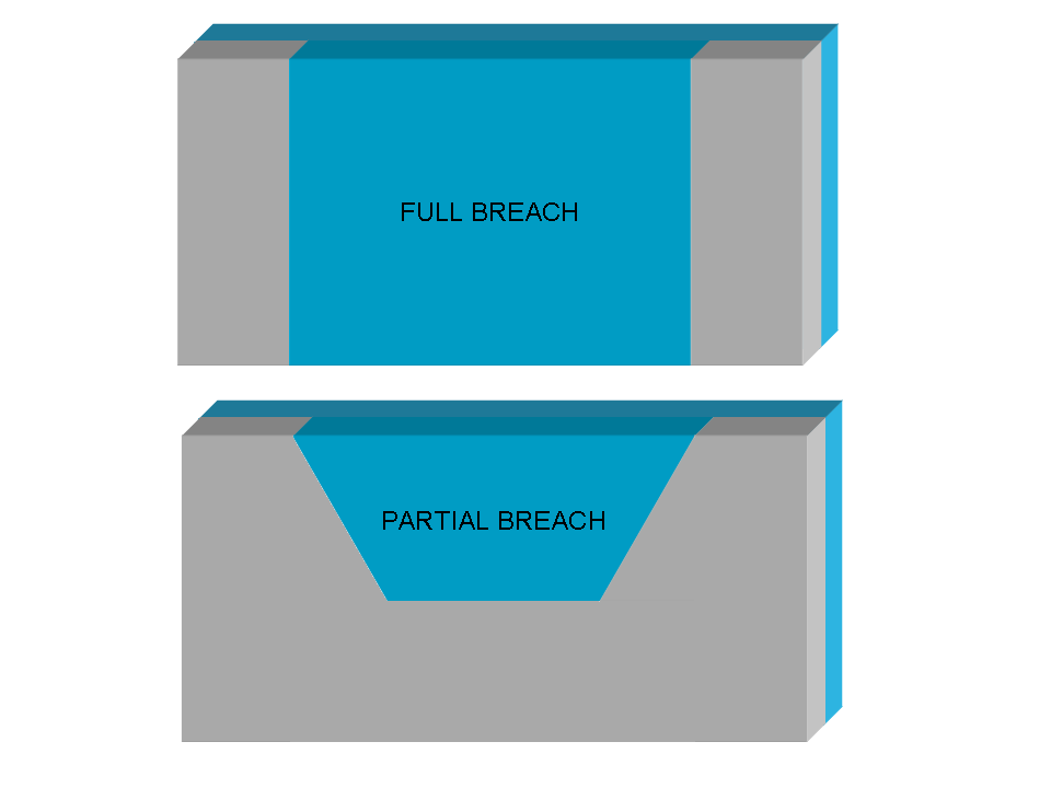
In case of total istantaeous dam break (configuration i), the initial
velocity is computed directly applying the SWE at the first time step;
while in case of partial dam breach (configuration ii) the user can
choose between don't use any hypothesis, like in the previous
configuration, or evaluate the initial velocity using the overflow
spillway equation:
V = 0.4 * sqrt(2 g h)
where V is the water flow velocity expressed in m/s, g is the
gravitational acceleration expressed in m/s2 and h is the
water depth in correspondence of the dam breach expresssed in meters
(m).
Optionally the user may modify the initial timestep used for the
numerical solution of the SWE (default value = 0.01 s), nevertheless
the timestep [], and choose a specific failure tipe corresponding to
different computational method for the initial velocity estimation.
AUTHORS
Roberto Marzocchi (e-mail) and
Massimiliano Cannata (e-mail).
The GRASS tool was developed by Institute of earth science (IST),
University of applied science of Italian Switzerland (SUPSI), Lugano -
Division of geomatics web-page
Actually the debug is assured by:
- Gter srl (Genoa, Italy)
- IST -SUPSI (Lugano,
Switzerland)
The numerical model, originally developed by the National Center for
Computational Hydroscience and Engineering of the University of
Mississippi, has been reformulated and modified by the authors
introducing important new features to consider the numerical stability
and the type of dam failure, and currently is written in ANSI C
programming language within GRASS.
SEE ALSO
r.lake,
r.reclass,
d.rast.arrow,
r.inund.fluv.
Details of the numerical model are presented in references.
REFERENCES
[1] Cannata M. & Marzocchi R. (2012). Two-dimensional dam break
flooding simulation: a GIS embedded approach. - Natural Hazards
61(3):1143-1159
[2]
Pdf
presentation of the work at the "X Meeting degli Utenti Italiani di
GRASS - GFOSS" (It) web-page
[3] Pdf presentation of the work at the FOSS4G 2009 (En) -
web-page
[4] Pdf presentation of the work at the Geoitalia 2011 conference
(En)-
document
Last changed: $27 februar 2013 09:40:00 CET $
SOURCE CODE
Available at: r.damflood source code
(history)
Latest change: Wednesday Mar 11 08:17:30 2026 in commit 2a14bbb