r.droka
Calculates run-out distance of a falling rock mass
r.droka dem=string start=string ang=float red=float m=float num=integer prefix=name [n=integer] [--overwrite] [--verbose] [--quiet] [--qq] [--ui]
Example:
r.droka dem=string start=string ang=0.0 red=0.9 m=0.0 num=0 prefix=name
grass.tools.Tools.r_droka(dem, start, ang, red=0.9, m, num, prefix, n=None, overwrite=None, verbose=None, quiet=None, superquiet=None)
Example:
tools = Tools()
tools.r_droka(dem="string", start="string", ang=0.0, red=0.9, m=0.0, num=0, prefix="name")
This grass.tools API is experimental in version 8.5 and expected to be stable in version 8.6.
grass.script.run_command("r.droka", dem, start, ang, red=0.9, m, num, prefix, n=None, overwrite=None, verbose=None, quiet=None, superquiet=None)
Example:
gs.run_command("r.droka", dem="string", start="string", ang=0.0, red=0.9, m=0.0, num=0, prefix="name")
Parameters
dem=string [required]
Digital Elevation Model
start=string [required]
Name of starting points map
ang=float [required]
Shadow angle
red=float [required]
Reduction value
Allowed values: 0-1
Default: 0.9
m=float [required]
Value of rock mass (kg)
num=integer [required]
Number of boulders (>=1)
prefix=name [required]
Prefix for output raster maps
n=integer
Buffer distance (meters)
--overwrite
Allow output files to overwrite existing files
--help
Print usage summary
--verbose
Verbose module output
--quiet
Quiet module output
--qq
Very quiet module output
--ui
Force launching GUI dialog
dem : str | np.ndarray, required
Digital Elevation Model
Used as: input, raster
start : str, required
Name of starting points map
Used as: input, vector
ang : float, required
Shadow angle
red : float, required
Reduction value
Allowed values: 0-1
Default: 0.9
m : float, required
Value of rock mass (kg)
num : int, required
Number of boulders (>=1)
prefix : str | type(np.ndarray) | type(np.array) | type(gs.array.array), required
Prefix for output raster maps
Used as: output, raster, name
n : int, optional
Buffer distance (meters)
overwrite : bool, optional
Allow output files to overwrite existing files
Default: None
verbose : bool, optional
Verbose module output
Default: None
quiet : bool, optional
Quiet module output
Default: None
superquiet : bool, optional
Very quiet module output
Default: None
Returns:
result : grass.tools.support.ToolResult | np.ndarray | tuple[np.ndarray] | None
If the tool produces text as standard output, a ToolResult object will be returned. Otherwise, None will be returned. If an array type (e.g., np.ndarray) is used for one of the raster outputs, the result will be an array and will have the shape corresponding to the computational region. If an array type is used for more than one raster output, the result will be a tuple of arrays.
Raises:
grass.tools.ToolError: When the tool ended with an error.
dem : str, required
Digital Elevation Model
Used as: input, raster
start : str, required
Name of starting points map
Used as: input, vector
ang : float, required
Shadow angle
red : float, required
Reduction value
Allowed values: 0-1
Default: 0.9
m : float, required
Value of rock mass (kg)
num : int, required
Number of boulders (>=1)
prefix : str, required
Prefix for output raster maps
Used as: output, raster, name
n : int, optional
Buffer distance (meters)
overwrite : bool, optional
Allow output files to overwrite existing files
Default: None
verbose : bool, optional
Verbose module output
Default: None
quiet : bool, optional
Quiet module output
Default: None
superquiet : bool, optional
Very quiet module output
Default: None
DESCRIPTION
The intersection between the topographic profile and the line starting from the point of detachment with a certain angle to the horizontal line defines the point of maximum propagation (Evans and Hungr, 1993; Jaboyedoff and Labiouse, 2003). The angle of inclination and the line of propagation are defined as zenith angle and shadow zone. This script defines rockfall zones from a digital elevation model (DEM) and vector layer containing starting point or points.
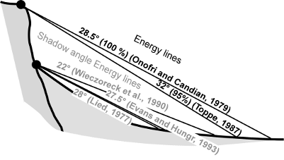
Energy line used for the cone method from the top or the bottom of a cliff (shadow angle), according to various authors (Image from Jaboyedoff and Labiouse, 2003)
INPUT
Digital Elevation Model: Name of elevation raster map.
Starting points: Name of vector map containing rockfall source area. It can be one point or more.
Shadow angle: Angle of inclination that defines the propagation zone. It's calculated from a horizontal plane starting from a source point: highest values determine a lowest propagation.
Reduction value: Reduction multiplicator for velocity. Default value is 0.9.
Number of boulders: For each starting point can be generated other random points used in the computations. By default points are located in a radius from the starting point equal to: (cell size * number of boulders)/2. Insert 1 for use only the original starting point or points. Note that a high number of boulders can make excessively long the calculation times.
Rock mass: Value of rock mass (Kg)
Output prefix: Name of prefix used for output raster maps
Buffer distance: This value defines the radius for randomly generating boulders starting from starting point. It's in the option dialog window.
OUTPUT
r.droka generates 5 raster maps and a vector map. The names of all output maps start with the prefix defined by the parameter prefix followed by the name of map
- prefix_propagation: raster map representing the area of propagation. If are used multiple source points, each pixel shows the percentage of passage (%)
- prefix_vel_max: maximum rock-fall translational velocities (m/sec)
- prefix_vel_med: medium rock-fall translational velocities (m/sec)
- prefix_vel_max: medium kinetic energy (kJ)
- prefix_en_max: maximum kinetic energy (kJ)
- prefix_starting: vector map of starting points
REFERENCES
FILIPELLO A., GIULIANI A., MANDRONE G. (2010) - Rock Slopes Failure Susceptibility Analysis: From Remote Sensing Measurements to Geographic Information System Raster Modules. American Journal of Environmental Sciences 6 (6): 489-494, 2010 ISSN 1553-345X 2010 Science Publications.
JABOYEDOFF M., LABIOUSE V. (2003) - Preliminary assessment of rockfall hazard based on GIS Data. Proceeding of the 10th ISRM Congress, South African Inst. Min. Met., Johannesburg, pp: 575-578
EVANS, S.G., HUNGR O. (1993). The assessment of rock fall hazard at the base of the talus slope. Can. Geotech. J., 30: 620-636. DOI: 10.1139/t93-054
SEE ALSO
AUTHORS
Andrea Filipello, University of Turin, Italy
Daniele Strigaro, University of Milan, Italy
SOURCE CODE
Available at: r.droka source code
(history)
Latest change: Wednesday Mar 11 08:17:30 2026 in commit 2a14bbb