r.in.srtm.region
Creates a DEM from 3 arcsec SRTM v2.1 or 1 arcsec SRTM v3 tiles.
r.in.srtm.region [-n21z] output=name username=string password=string [url=string] [local=name] [region=xmin,ymin,xmax,ymax] [memory=integer] [method=string] [resolution=float] [--overwrite] [--verbose] [--quiet] [--qq] [--ui]
Example:
r.in.srtm.region output=name username=string password=string
grass.tools.Tools.r_in_srtm_region(output, username, password, url=None, local=None, region=None, memory=300, method=None, resolution=None, flags=None, overwrite=None, verbose=None, quiet=None, superquiet=None)
Example:
tools = Tools()
tools.r_in_srtm_region(output="name", username="string", password="string")
This grass.tools API is experimental in version 8.5 and expected to be stable in version 8.6.
grass.script.run_command("r.in.srtm.region", output, username, password, url=None, local=None, region=None, memory=300, method=None, resolution=None, flags=None, overwrite=None, verbose=None, quiet=None, superquiet=None)
Example:
gs.run_command("r.in.srtm.region", output="name", username="string", password="string")
Parameters
output=name [required]
Name for output raster map
username=string [required]
Username for authentication
password=string [required]
Password for authentication
url=string
Base URL to fetch SRTM tiles
local=name
Local folder with SRTM tiles
Use local folder instead of URL to retrieve SRTM tiles
region=xmin,ymin,xmax,ymax
Import subregion only (default is current region)
Format: xmin,ymin,xmax,ymax - usually W,S,E,N
memory=integer
Memory in MB for interpolation
Default: 300
method=string
Resampling method to use for reprojection (required if location projection not longlat)
Allowed values: nearest, bilinear, bicubic, lanczos, bilinear_f, bicubic_f, lanczos_f
nearest: nearest neighbor
bilinear: bilinear interpolation
bicubic: bicubic interpolation
lanczos: lanczos filter
bilinear_f: bilinear interpolation with fallback
bicubic_f: bicubic interpolation with fallback
lanczos_f: lanczos filter with fallback
resolution=float
Resolution of output raster map (required if location projection not longlat)
-n
Fill null cells
-2
Import SRTM v2 tiles
Default: Import SRTM v3 tiles
-1
Input is a 1-arcsec tile (default: 3-arcsec)
-z
Create zero elevation for missing tiles
--overwrite
Allow output files to overwrite existing files
--help
Print usage summary
--verbose
Verbose module output
--quiet
Quiet module output
--qq
Very quiet module output
--ui
Force launching GUI dialog
output : str | type(np.ndarray) | type(np.array) | type(gs.array.array), required
Name for output raster map
Used as: output, raster, name
username : str, required
Username for authentication
password : str, required
Password for authentication
url : str, optional
Base URL to fetch SRTM tiles
local : str, optional
Local folder with SRTM tiles
Use local folder instead of URL to retrieve SRTM tiles
Used as: input, dir, name
region : tuple[float, float, float, float] | list[float] | str, optional
Import subregion only (default is current region)
Format: xmin,ymin,xmax,ymax - usually W,S,E,N
Used as: xmin,ymin,xmax,ymax
memory : int, optional
Memory in MB for interpolation
Default: 300
method : str, optional
Resampling method to use for reprojection (required if location projection not longlat)
Allowed values: nearest, bilinear, bicubic, lanczos, bilinear_f, bicubic_f, lanczos_f
nearest: nearest neighbor
bilinear: bilinear interpolation
bicubic: bicubic interpolation
lanczos: lanczos filter
bilinear_f: bilinear interpolation with fallback
bicubic_f: bicubic interpolation with fallback
lanczos_f: lanczos filter with fallback
resolution : float, optional
Resolution of output raster map (required if location projection not longlat)
flags : str, optional
Allowed values: n, 2, 1, z
n
Fill null cells
2
Import SRTM v2 tiles
Default: Import SRTM v3 tiles
1
Input is a 1-arcsec tile (default: 3-arcsec)
z
Create zero elevation for missing tiles
overwrite : bool, optional
Allow output files to overwrite existing files
Default: None
verbose : bool, optional
Verbose module output
Default: None
quiet : bool, optional
Quiet module output
Default: None
superquiet : bool, optional
Very quiet module output
Default: None
Returns:
result : grass.tools.support.ToolResult | np.ndarray | tuple[np.ndarray] | None
If the tool produces text as standard output, a ToolResult object will be returned. Otherwise, None will be returned. If an array type (e.g., np.ndarray) is used for one of the raster outputs, the result will be an array and will have the shape corresponding to the computational region. If an array type is used for more than one raster output, the result will be a tuple of arrays.
Raises:
grass.tools.ToolError: When the tool ended with an error.
output : str, required
Name for output raster map
Used as: output, raster, name
username : str, required
Username for authentication
password : str, required
Password for authentication
url : str, optional
Base URL to fetch SRTM tiles
local : str, optional
Local folder with SRTM tiles
Use local folder instead of URL to retrieve SRTM tiles
Used as: input, dir, name
region : tuple[float, float, float, float] | list[float] | str, optional
Import subregion only (default is current region)
Format: xmin,ymin,xmax,ymax - usually W,S,E,N
Used as: xmin,ymin,xmax,ymax
memory : int, optional
Memory in MB for interpolation
Default: 300
method : str, optional
Resampling method to use for reprojection (required if location projection not longlat)
Allowed values: nearest, bilinear, bicubic, lanczos, bilinear_f, bicubic_f, lanczos_f
nearest: nearest neighbor
bilinear: bilinear interpolation
bicubic: bicubic interpolation
lanczos: lanczos filter
bilinear_f: bilinear interpolation with fallback
bicubic_f: bicubic interpolation with fallback
lanczos_f: lanczos filter with fallback
resolution : float, optional
Resolution of output raster map (required if location projection not longlat)
flags : str, optional
Allowed values: n, 2, 1, z
n
Fill null cells
2
Import SRTM v2 tiles
Default: Import SRTM v3 tiles
1
Input is a 1-arcsec tile (default: 3-arcsec)
z
Create zero elevation for missing tiles
overwrite : bool, optional
Allow output files to overwrite existing files
Default: None
verbose : bool, optional
Verbose module output
Default: None
quiet : bool, optional
Quiet module output
Default: None
superquiet : bool, optional
Very quiet module output
Default: None
DESCRIPTION
r.in.srtm.region imports all SRTM tiles covering the current region or region extents given with region into GRASS, patches the tiles together and optionally interpolates holes for SRTM V2.1. The SRTM V003 products are already void-filled.
r.in.srtm.region downloads (SRTM product description)
- SRTMGL1 V003 tiles at 1 arc second (about 30 meters) resolution,
void-filled from:
https://e4ftl01.cr.usgs.gov/MEASURES/SRTMGL1.003/2000.02.11/ - SRTMGL3 V003 tiles at 3 arc seconds (about 90 meters) resolution,
void-filled from:
https://e4ftl01.cr.usgs.gov/MEASURES/SRTMGL3.003/2000.02.11/ - SRTM V2.1 tiles at 3 arc second (about 90 meters) resolution from: http://dds.cr.usgs.gov/srtm/
- or, optionally r.in.srtm.region uses a local folder with previously downloaded SRTM data files if the local option is given.
Importantly, for the SRTM tiles download a user registration is needed at https://urs.earthdata.nasa.gov/users/new
In the user profile, two specific applications must be approved in the "My application" tab:
- "LP DAAC Data Pool" application, and
- "Earthdata Search" application.
EXAMPLE
Import of SRTMGL1 V003 (1 arc seconds \~ 30m) covering the current computational region:
# run in LatLong location - Sicily East, Italy
g.region n=39 s=37 w=14 e=16 res=0:00:01 -p

# use own credentials here
r.in.srtm.region -1 user="my_nasa_user" password="my_nasa_pw" output=srtm_sicily_1arc memory=2000
r.univar srtm_sicily_1arc
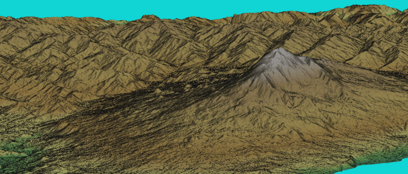
Figure: Eta volcano (Sicily, Italy) shown in NVIZ
SEE ALSO
r.in.srtm, r.in.nasadem (addon)
The Shuttle Radar Topography Mission homepage at NASA's JPL (see also MEaSUREs Data Product Table - SRTM).
SRTMGL1: NASA Shuttle Radar Topography Mission Global 1 arc second V003
NASA JPL. (2013). NASA Shuttle Radar Topography Mission Global 1 arc second. NASA LP DAAC. https://doi.org/10.5067/MEaSUREs/SRTM/SRTMGL1.003
REFERENCES
M. Neteler, 2005. SRTM and VMAP0 data in OGR and GRASS. GRASS Newsletter, Vol.3, pp. 2-6, June 2005. ISSN 1614-8746.
AUTHORS
Markus Metz
Reprojection support: Anika Bettge, mundialis
SOURCE CODE
Available at: r.in.srtm.region source code
(history)
Latest change: Wednesday Mar 11 08:17:30 2026 in commit 2a14bbb