r.traveltime
Estimation of travel times/isochrones.
Computes the travel time of surface runoff to an outlet
r.traveltime [-q] dir=name accu=name dtm=name manningsn=name out_x=string out_y=string threshold=string b=string nchannel=string dis=string [slopemin=string] out=name [--overwrite] [--verbose] [--quiet] [--qq] [--ui]
Example:
r.traveltime dir=name accu=name dtm=name manningsn=name out_x=string out_y=string threshold=string b=string nchannel=string dis=string out=name
grass.tools.Tools.r_traveltime(dir, accu, dtm, manningsn, out_x, out_y, threshold, b, nchannel, dis, slopemin=None, out, flags=None, overwrite=None, verbose=None, quiet=None, superquiet=None)
Example:
tools = Tools()
tools.r_traveltime(dir="name", accu="name", dtm="name", manningsn="name", out_x="string", out_y="string", threshold="string", b="string", nchannel="string", dis="string", out="name")
This grass.tools API is experimental in version 8.5 and expected to be stable in version 8.6.
grass.script.run_command("r.traveltime", dir, accu, dtm, manningsn, out_x, out_y, threshold, b, nchannel, dis, slopemin=None, out, flags=None, overwrite=None, verbose=None, quiet=None, superquiet=None)
Example:
gs.run_command("r.traveltime", dir="name", accu="name", dtm="name", manningsn="name", out_x="string", out_y="string", threshold="string", b="string", nchannel="string", dis="string", out="name")
Parameters
dir=name [required]
Flow direction map (e.g. derived by r.watershed)
accu=name [required]
Flow accumulation map (e.g. derived by r.watershed)
dtm=name [required]
Depressionless, filled terrain model (e.g. derived by r.fill.dir)
manningsn=name [required]
Map with Manning's n value for surface roughness
out_x=string [required]
x coordinate of basin outlet
out_y=string [required]
y coordinate of basin outlet
threshold=string [required]
Minimum number of cells (threshold) that classify cell as channel
b=string [required]
Channel width
nchannel=string [required]
Channel roughness (Manning's n)
dis=string [required]
Specific discharge [l/s/km**2]
slopemin=string
Minimum slope for flat areas [m/m]
out=name [required]
Output travel time map [seconds]
-q
Quiet
--overwrite
Allow output files to overwrite existing files
--help
Print usage summary
--verbose
Verbose module output
--quiet
Quiet module output
--qq
Very quiet module output
--ui
Force launching GUI dialog
dir : str | np.ndarray, required
Flow direction map (e.g. derived by r.watershed)
Used as: input, raster, name
accu : str | np.ndarray, required
Flow accumulation map (e.g. derived by r.watershed)
Used as: input, raster, name
dtm : str | np.ndarray, required
Depressionless, filled terrain model (e.g. derived by r.fill.dir)
Used as: input, raster, name
manningsn : str | np.ndarray, required
Map with Manning's n value for surface roughness
Used as: input, raster, name
out_x : str | np.ndarray, required
x coordinate of basin outlet
Used as: input, raster
out_y : str | np.ndarray, required
y coordinate of basin outlet
Used as: input, raster
threshold : str | np.ndarray, required
Minimum number of cells (threshold) that classify cell as channel
Used as: input, raster
b : str | np.ndarray, required
Channel width
Used as: input, raster
nchannel : str | np.ndarray, required
Channel roughness (Manning's n)
Used as: input, raster
dis : str | np.ndarray, required
Specific discharge [l/s/km**2]
Used as: input, raster
slopemin : str | np.ndarray, optional
Minimum slope for flat areas [m/m]
Used as: input, raster
out : str | type(np.ndarray) | type(np.array) | type(gs.array.array), required
Output travel time map [seconds]
Used as: output, raster, name
flags : str, optional
Allowed values: q
q
Quiet
overwrite : bool, optional
Allow output files to overwrite existing files
Default: None
verbose : bool, optional
Verbose module output
Default: None
quiet : bool, optional
Quiet module output
Default: None
superquiet : bool, optional
Very quiet module output
Default: None
Returns:
result : grass.tools.support.ToolResult | np.ndarray | tuple[np.ndarray] | None
If the tool produces text as standard output, a ToolResult object will be returned. Otherwise, None will be returned. If an array type (e.g., np.ndarray) is used for one of the raster outputs, the result will be an array and will have the shape corresponding to the computational region. If an array type is used for more than one raster output, the result will be a tuple of arrays.
Raises:
grass.tools.ToolError: When the tool ended with an error.
dir : str, required
Flow direction map (e.g. derived by r.watershed)
Used as: input, raster, name
accu : str, required
Flow accumulation map (e.g. derived by r.watershed)
Used as: input, raster, name
dtm : str, required
Depressionless, filled terrain model (e.g. derived by r.fill.dir)
Used as: input, raster, name
manningsn : str, required
Map with Manning's n value for surface roughness
Used as: input, raster, name
out_x : str, required
x coordinate of basin outlet
Used as: input, raster
out_y : str, required
y coordinate of basin outlet
Used as: input, raster
threshold : str, required
Minimum number of cells (threshold) that classify cell as channel
Used as: input, raster
b : str, required
Channel width
Used as: input, raster
nchannel : str, required
Channel roughness (Manning's n)
Used as: input, raster
dis : str, required
Specific discharge [l/s/km**2]
Used as: input, raster
slopemin : str, optional
Minimum slope for flat areas [m/m]
Used as: input, raster
out : str, required
Output travel time map [seconds]
Used as: output, raster, name
flags : str, optional
Allowed values: q
q
Quiet
overwrite : bool, optional
Allow output files to overwrite existing files
Default: None
verbose : bool, optional
Verbose module output
Default: None
quiet : bool, optional
Quiet module output
Default: None
superquiet : bool, optional
Very quiet module output
Default: None
DESCRIPTION
r.traveltime computes the travel time of surface runoff to an outlet.
The program starts at the basin outlet and calculates the travel time
for each raster cell recursively. A drainage area related threshold
considers either surface runoff or channel runoff. Travel times are
derived by assuming kinematic wave approximation.
In order to derive channel flow velocities, an equilibrium discharge for
each cell is calculated (Q=Area*specific discharge).
The results can be used to derive a time-area function. This might be
useful for precipitation-runoff calculations (estimation of flood
predictions) with a lumped hydrological model (user-specified unit
hydrograph).
REMARKS
The program ist restricted to SI units (meters). The algorithm is
recursive. Maybe it will not work with extensive datasets. It is assumed
that the minimum slope is 0.001. For smaller gradients the program uses
this value.
Please not that the flow accumulation map must be defined as single
direction. Multiple flow directions are not supported. Thus, the "SFD
(D8) flow" option has to be set if, e.g., the r.watershed module is used
to generate the input files (parameter s). The flow accumulation map
should include positive values only (-a of r.watershed). Flow direction
definitions are in accordance to the r.fill.dir program using the
"agnps" format option.
KNOWN ISSUES
The program does not work correctly if Manning's roughness grid is defined as double (float expected). To define a simple uniform roughness distribution try: r.mapcalc 'roughness = 0.1f'
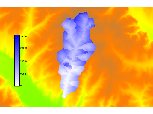
EXAMPLE
This example uses the North Carolina sample dataset.
g.region raster=elevation
r.mapcalc "n = 0.1f"
r.fill.dir input=elevation output=fill direction=flowdir format=agnps
r.fill.dir input=fill output=fill2 direction=flowdir2 format=agnps
r.watershed -a -s elevation=fill2 accumulation=accu
r.traveltime --overwrite dir=flowdir2 accu=accu dtm=fill2 manningsn=n \
    out_x=634613 out_y=217014 threshold=250 b=3 nchannel=0.03 slopemin=0.01 \
    dis=900 out=ttime
r.colors ttime colors=blues
SEE ALSO
r.watershed,
r.fill.dir
https://jesbergwetter.twoday.net/stories/4845555/
REFERENCES
- Kilgore, J. L. (1997): Development and evaluation of a GIS-based spatially distributed unit hydrograph model, master thesis, Virginia Polytechnic Institute and State University.
- Melesse, A. M., Graham, W. D. (2004): Storm runoff predicition based on a spatially distributed travel time method utilizing remote sensing and GIS, Journal of the American Water Resources Association, 8, 863-879.
- Muzik, I. (1996): Flood modelling with GIS-derived distributed unit hydrographs, Hydrological Processes, 10, 1401-1409.
AUTHOR
Kristian Foerster
SOURCE CODE
Available at: r.traveltime source code
(history)
Latest change: Wednesday Mar 11 08:17:30 2026 in commit 2a14bbb