v.surf.mass
Performs mass-preserving area interpolation.
v.surf.mass [-z] input=name [weight=name] [layer=string] [column=name] output=name [iterations=integer] [threshold=float] [memory=integer] [--overwrite] [--verbose] [--quiet] [--qq] [--ui]
Example:
v.surf.mass input=name output=name
grass.tools.Tools.v_surf_mass(input, weight=None, layer="1", column=None, output, iterations=100, threshold=1e-8, memory=300, flags=None, overwrite=None, verbose=None, quiet=None, superquiet=None)
Example:
tools = Tools()
tools.v_surf_mass(input="name", output="name")
This grass.tools API is experimental in version 8.5 and expected to be stable in version 8.6.
grass.script.run_command("v.surf.mass", input, weight=None, layer="1", column=None, output, iterations=100, threshold=1e-8, memory=300, flags=None, overwrite=None, verbose=None, quiet=None, superquiet=None)
Example:
gs.run_command("v.surf.mass", input="name", output="name")
Parameters
input=name [required]
Name of input vector area map
Or data source for direct OGR access
weight=name
Name of optional weighing raster map
Name of input raster map
layer=string
Layer number or name
Vector features can have category values in different layers. This number determines which layer to use. When used with direct OGR access this is the layer name.
Default: 1
column=name
Name of attribute column with values to approximate
output=name [required]
Name for output raster map
iterations=integer
Maximum number of iterations
Default: 100
threshold=float
Threshold for iterations
Default: 1e-8
memory=integer
Maximum memory to be used for raster output (in MB)
Default: 300
-z
Use centroid z coordinates for approximation (3D vector maps only)
--overwrite
Allow output files to overwrite existing files
--help
Print usage summary
--verbose
Verbose module output
--quiet
Quiet module output
--qq
Very quiet module output
--ui
Force launching GUI dialog
input : str, required
Name of input vector area map
Or data source for direct OGR access
Used as: input, vector, name
weight : str | np.ndarray, optional
Name of optional weighing raster map
Name of input raster map
Used as: input, raster, name
layer : str, optional
Layer number or name
Vector features can have category values in different layers. This number determines which layer to use. When used with direct OGR access this is the layer name.
Used as: input, layer
Default: 1
column : str, optional
Name of attribute column with values to approximate
Used as: input, dbcolumn, name
output : str | type(np.ndarray) | type(np.array) | type(gs.array.array), required
Name for output raster map
Used as: output, raster, name
iterations : int, optional
Maximum number of iterations
Default: 100
threshold : float, optional
Threshold for iterations
Default: 1e-8
memory : int, optional
Maximum memory to be used for raster output (in MB)
Default: 300
flags : str, optional
Allowed values: z
z
Use centroid z coordinates for approximation (3D vector maps only)
overwrite : bool, optional
Allow output files to overwrite existing files
Default: None
verbose : bool, optional
Verbose module output
Default: None
quiet : bool, optional
Quiet module output
Default: None
superquiet : bool, optional
Very quiet module output
Default: None
Returns:
result : grass.tools.support.ToolResult | np.ndarray | tuple[np.ndarray] | None
If the tool produces text as standard output, a ToolResult object will be returned. Otherwise, None will be returned. If an array type (e.g., np.ndarray) is used for one of the raster outputs, the result will be an array and will have the shape corresponding to the computational region. If an array type is used for more than one raster output, the result will be a tuple of arrays.
Raises:
grass.tools.ToolError: When the tool ended with an error.
input : str, required
Name of input vector area map
Or data source for direct OGR access
Used as: input, vector, name
weight : str, optional
Name of optional weighing raster map
Name of input raster map
Used as: input, raster, name
layer : str, optional
Layer number or name
Vector features can have category values in different layers. This number determines which layer to use. When used with direct OGR access this is the layer name.
Used as: input, layer
Default: 1
column : str, optional
Name of attribute column with values to approximate
Used as: input, dbcolumn, name
output : str, required
Name for output raster map
Used as: output, raster, name
iterations : int, optional
Maximum number of iterations
Default: 100
threshold : float, optional
Threshold for iterations
Default: 1e-8
memory : int, optional
Maximum memory to be used for raster output (in MB)
Default: 300
flags : str, optional
Allowed values: z
z
Use centroid z coordinates for approximation (3D vector maps only)
overwrite : bool, optional
Allow output files to overwrite existing files
Default: None
verbose : bool, optional
Verbose module output
Default: None
quiet : bool, optional
Quiet module output
Default: None
superquiet : bool, optional
Very quiet module output
Default: None
DESCRIPTION
v.surf.mass creates a raster surface from vector areas, preserving the value of the area attribute. For example, if the selected area attibute is the population count, the sum of all pixel values in a given area is equal to the area's population count.
NOTES
The current region needs to be prepared with g.region, choosing a resolution such that the smallest area is covered by at least four pixels. The current region should be completely inside the bounding box of the vector.
EXAMPLE
Pycnophylactic interpolation of Voronoi triangles
Pycnophylactic interpolation of Voronoi triangles using annual precipitation in the North Carolina sample data:
# setting the region
g.region -p raster=elev_state_500m

# create Voronoi diagram based on meteorological stations
v.voronoi input=precip_30ynormals output=precip_annual

# List of attributes for the vector precip_annual
v.info -c precip_annual

# v.surf.mass converts attributes to density, but rainfall is
# typically measured in mm which is the same for all cells in the
# same input area, thus:
# new column for area size and adjusted precipitation
v.db.addcolumn map=precip_annual \
     column="area double precision, prec_adj double precision"
v.to.db map=precip_annual column=area option=area units=meters

# Getting the size of the smallest area
v.db.univar precip_annual column=area

# The smallest area with some population is 1.20789e+08 square meters
# and with a resolution of 5000 meters covered by appr. four pixels
# (depending on the shape of the area). Adjust region for that:
g.region res=5000 -ap

# adjust precipitation values: multiply by area size, dived by pixel size
v.db.update map=precip_annual column=prec_adj \
     qcolumn="annual * area / 25000000"

# mass-preserving area interpolation
v.surf.mass input=precip_annual output=precip_annual_pycno column=prec_adj iterations=200

# rasterize Voronoi diagram for comparison
v.to.rast precip_annual out=precip_annual_voronoi type=area use=attr attrcolumn=annual

# verify results
d.mon wx0
d.rast.leg precip_annual_voronoi
d.rast.leg precip_annual_pycno
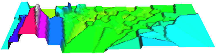
Annual precipitation (30 years avg.) of North Carolina shown as Voronoi
diagram based on meteorological stations (perspective view in NVIZ).
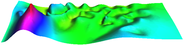
Smooth Pycnophylactic Interpolation of annual precipitation (30 years
avg.) of North Carolina using the Voronoi diagram map based on
meteorological stations (perspective view in NVIZ).
REFERENCES
Tobler WR. 1979. Smooth Pycnophylactic Interpolation for Geographical Regions. Journal of the American Statistical Association, 74 (367): 519-530 (PDF).
AUTHOR
Markus Metz
SOURCE CODE
Available at: v.surf.mass source code
(history)
Latest change: Tuesday Feb 17 14:54:26 2026 in commit 051b9c1