r.local.relief
Creates a local relief model from elevation map.
r.local.relief [-ivngf] input=string output=string [neighborhood_size=integer] [color_table=string] [shaded_output=name] [--overwrite] [--verbose] [--quiet] [--qq] [--ui]
Example:
r.local.relief input=string output=string
grass.tools.Tools.r_local_relief(input, output, neighborhood_size=11, color_table=None, shaded_output=None, flags=None, overwrite=None, verbose=None, quiet=None, superquiet=None)
Example:
tools = Tools()
tools.r_local_relief(input="string", output="string")
This grass.tools API is experimental in version 8.5 and expected to be stable in version 8.6.
grass.script.run_command("r.local.relief", input, output, neighborhood_size=11, color_table=None, shaded_output=None, flags=None, overwrite=None, verbose=None, quiet=None, superquiet=None)
Example:
gs.run_command("r.local.relief", input="string", output="string")
Parameters
input=string [required]
Name of the input elevation raster map
output=string [required]
Name for output local relief map
neighborhood_size=integer
Smoothing neighborhood size
Neighborhood size used when smoothing the elevation model
Allowed values: 0-
Default: 11
color_table=string
Color table for the local relief model raster map
If not provided, grey is used for output and differences is used for the shaded_output
Allowed values: grey, differences
shaded_output=name
Local relief combined with shaded relief
Local relief model combined with shaded relief of the original elevation
-i
Save intermediate maps
-v
Use bspline interpolation to construct the surface
Uses v.surf.bspline cubic interpolation instead of r.fillnulls cubic interpolation.
-n
Invert colors in the color table
-g
Logarithmic scaling of the color table
-f
Do not perform histogram equalization on the color table
--overwrite
Allow output files to overwrite existing files
--help
Print usage summary
--verbose
Verbose module output
--quiet
Quiet module output
--qq
Very quiet module output
--ui
Force launching GUI dialog
input : str | np.ndarray, required
Name of the input elevation raster map
Used as: input, raster
output : str | type(np.ndarray) | type(np.array) | type(gs.array.array), required
Name for output local relief map
Used as: output, raster
neighborhood_size : int, optional
Smoothing neighborhood size
Neighborhood size used when smoothing the elevation model
Allowed values: 0-
Default: 11
color_table : str, optional
Color table for the local relief model raster map
If not provided, grey is used for output and differences is used for the shaded_output
Allowed values: grey, differences
shaded_output : str | type(np.ndarray) | type(np.array) | type(gs.array.array), optional
Local relief combined with shaded relief
Local relief model combined with shaded relief of the original elevation
Used as: output, raster, name
flags : str, optional
Allowed values: i, v, n, g, f
i
Save intermediate maps
v
Use bspline interpolation to construct the surface
Uses v.surf.bspline cubic interpolation instead of r.fillnulls cubic interpolation.
n
Invert colors in the color table
g
Logarithmic scaling of the color table
f
Do not perform histogram equalization on the color table
overwrite : bool, optional
Allow output files to overwrite existing files
Default: None
verbose : bool, optional
Verbose module output
Default: None
quiet : bool, optional
Quiet module output
Default: None
superquiet : bool, optional
Very quiet module output
Default: None
Returns:
result : grass.tools.support.ToolResult | np.ndarray | tuple[np.ndarray] | None
If the tool produces text as standard output, a ToolResult object will be returned. Otherwise, None will be returned. If an array type (e.g., np.ndarray) is used for one of the raster outputs, the result will be an array and will have the shape corresponding to the computational region. If an array type is used for more than one raster output, the result will be a tuple of arrays.
Raises:
grass.tools.ToolError: When the tool ended with an error.
input : str, required
Name of the input elevation raster map
Used as: input, raster
output : str, required
Name for output local relief map
Used as: output, raster
neighborhood_size : int, optional
Smoothing neighborhood size
Neighborhood size used when smoothing the elevation model
Allowed values: 0-
Default: 11
color_table : str, optional
Color table for the local relief model raster map
If not provided, grey is used for output and differences is used for the shaded_output
Allowed values: grey, differences
shaded_output : str, optional
Local relief combined with shaded relief
Local relief model combined with shaded relief of the original elevation
Used as: output, raster, name
flags : str, optional
Allowed values: i, v, n, g, f
i
Save intermediate maps
v
Use bspline interpolation to construct the surface
Uses v.surf.bspline cubic interpolation instead of r.fillnulls cubic interpolation.
n
Invert colors in the color table
g
Logarithmic scaling of the color table
f
Do not perform histogram equalization on the color table
overwrite : bool, optional
Allow output files to overwrite existing files
Default: None
verbose : bool, optional
Verbose module output
Default: None
quiet : bool, optional
Quiet module output
Default: None
superquiet : bool, optional
Very quiet module output
Default: None
DESCRIPTION
r.local.relief generates a local relief model (LRM) from lidar-derived high-resolution DEMs. Local relief models enhance the visibility of small-scale surface features by removing large-scale landforms from the DEM.
Generating the LRM is accomplished in 7 steps (Hesse 2010:69):
- Creation of the DEM from the LIDAR data. Buildings, trees and other objects on the earth's surface should be removed.
- Apply a low pass filter to the DEM. The low pass filter approximates the large-scale landforms. The neighborhood size of the low pass filter determines the scale of features that will be visible in the LRM. A default neighborhood size of 11 is used.
- Subtract the low-pass filter result from the DEM to get the local relief.
- Extract the zero contour lines from the difference map.
- Extract the input DEM's elevation values along the zero contour lines.
- Create a purged DEM by interpolating the null values between the rasterized contours generated in the previous step. This layer represents the large-scale landforms that will be removed to expose the local relief in the final step.
- Subtract the purged DEM from the original DEM to get the local relief model.
The interpolation step is performed by the r.fillnulls module by default (using cubic interpolation). If this is not working on your data, you can use -v flag to use v.surf.bspline cubic interpolation instead (this might be slower on some types of data).
OUTPUT
The final local relief model is named according to the output parameter. When the -i flag is specified, r.local.relief creates additional output files representing the intermediate steps in the LRM generation process. The names and number of the intermediate files vary depending on whether r.fillnulls (default) or v.surf.bspline (specified by using the -v flag) is used for interpolation. The intermediate maps are composed of the user-specified output parameter and suffixes describing the intermediate map.
Without using the -v flag (r.fillnulls interpolation), intermediate maps have the following suffixes:
_smooth_elevation: The result of running the low pass filter on the DEM._subtracted_smooth_elevation: The result of subtracting the low pass filter map from the DEM._raster_contours_with_values: The rasterized zero contours with the values from elevation map._purged_elevation: The raster interpolated from the _raster_contours_with_values map based that represents the large-scale landforms.
With using the -v flag (v.surf.bspline interpolation), intermediate maps have the following suffixes:
_smooth_elevation: The result of running the low pass filter on the DEM._subtracted_smooth_elevation: The result of subtracting the low pass filter map from the DEM._vector_contours: The zero contours extracted from the DEM._contour_points: The points extractacted along the zero contour lines with the input DEM elevation values._purged_elevation: The raster interpolated from the _contour_points map that represents the large-scale landforms.
The module sets equalized gray scale color table for local relief model map and for the elevation difference (subtracted elevations). The color tables of other raster maps are set to the same color table as the input elevation map has.
EXAMPLE
Basic example using the default neighborhood size of 11:
r.local.relief input=elevation output=lrm11
Example with a custom neighborhood size of 25:
r.local.relief input=elevation output=lrm25 neighborhood_size=25
Example using the default neighborhood size of 11 and saving the intermediate maps:
r.local.relief -i input=elevation output=lrm11
Example using the default neighborhood size of 11 with bspline interpolation and saving the intermediate maps:
r.local.relief -i -v input=elevation output=lrm11
Example in NC sample location (area of Raleigh downtown):
# set the computational region to area of interest
g.region n=228010 s=223380 w=637980 e=644920 res=10

# compute local relief model
r.local.relief input=elevation output=elevation_lrm

# show the maps, e.g. using monitors
d.mon wx0
d.rast elevation
d.rast elevation_lrm

# try alternative red (negative values) and blue (positive values) color table
# color table shows only the high values which hides small streets
# for non-unix operating systems use file or interactive input in GUI
# instead of rules=- and EOF syntax
r.colors map=elevation_lrm@PERMANENT rules=- <<EOF
100% 0:0:255
0 255:255:255
0% 255:0:0
nv 255:255:255
default 255:255:255
EOF

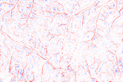
Figure: Local relief model of downtown Raleigh area created from elevation raster map in NC sample location with the default (gray scale) color table and custom red (negative values) and blue (positive values) color table
SEE ALSO
r.relief, r.shaded.pca, r.skyview
REFERENCES
- Hesse, Ralf (2010). LiDAR-derived Local Relief Models - a new tool for archaeological prospection. Archaeological Prospection 17:67-72.
- Bennett, Rebecca (2011). Archaeological Remote Sensing: Visualization and Analysis of grass-dominated environments using laser scanning and digital spectra data. Unpublished PhD Thesis. Electronic Document, http://eprints.bournemouth.ac.uk/20459/1/Bennett%2C_Rebecca_PhD_Thesis_2011.pdf, Accessed 25 February 2013. (provided bash script with v.surf.bspline-based implementation)
AUTHORS
Vaclav Petras, NCSU OSGeoREL,
Eric Goddard
SOURCE CODE
Available at: r.local.relief source code
(history)
Latest change: Wednesday Mar 11 08:17:30 2026 in commit 2a14bbb