r.shaded.pca
Creates relief shades from various directions and combines them into RGB composition.
The combined shades highlight terrain features which wouldn't be visible using standard shading technique.
r.shaded.pca input=string output=string [altitude=float] [nazimuths=integer] [zscale=float] [scale=float] [units=string] [shades_basename=string] [pca_shades_basename=string] [nprocs=integer] [--overwrite] [--verbose] [--quiet] [--qq] [--ui]
Example:
r.shaded.pca input=string output=string
grass.tools.Tools.r_shaded_pca(input, output, altitude=30, nazimuths=8, zscale=1, scale=1, units=None, shades_basename=None, pca_shades_basename=None, nprocs=1, overwrite=None, verbose=None, quiet=None, superquiet=None)
Example:
tools = Tools()
tools.r_shaded_pca(input="string", output="string")
This grass.tools API is experimental in version 8.5 and expected to be stable in version 8.6.
grass.script.run_command("r.shaded.pca", input, output, altitude=30, nazimuths=8, zscale=1, scale=1, units=None, shades_basename=None, pca_shades_basename=None, nprocs=1, overwrite=None, verbose=None, quiet=None, superquiet=None)
Example:
gs.run_command("r.shaded.pca", input="string", output="string")
Parameters
input=string [required]
Name of the input elevation raster map
output=string [required]
Name for output PCA shaded relief map
altitude=float
Altitude of the sun in degrees above the horizon
Allowed values: 0-90
Default: 30
nazimuths=integer
The number of azimuths (suggested values are 4, 8, 16, 32)
Default: 8
zscale=float
Factor for exaggerating relief
Default: 1
scale=float
Azimuth of the sun in degrees to the east of north
Default: 1
units=string
Elevation units (overrides scale factor)
Allowed values: intl, survey
intl: international feet
survey: survey feet
shades_basename=string
Base name for output shades map
A base of the name of shades maps for all azimuths. An underscore ('') and a azimuth will be added to the base name. When empty, no maps will be outputted (although they need to be generated).
pca_shades_basename=string
Base name for output PCA shades map
A base of the name of PCA shades maps. An underscore ('') and a azimuth will be added to the base name. When empty, no maps will be outputted (although they need to be generated).
nprocs=integer
Number of r.shade.relief processes to run in parallel
Allowed values: 1-
Default: 1
--overwrite
Allow output files to overwrite existing files
--help
Print usage summary
--verbose
Verbose module output
--quiet
Quiet module output
--qq
Very quiet module output
--ui
Force launching GUI dialog
input : str | np.ndarray, required
Name of the input elevation raster map
Used as: input, raster
output : str | type(np.ndarray) | type(np.array) | type(gs.array.array), required
Name for output PCA shaded relief map
Used as: output, raster
altitude : float, optional
Altitude of the sun in degrees above the horizon
Allowed values: 0-90
Default: 30
nazimuths : int, optional
The number of azimuths (suggested values are 4, 8, 16, 32)
Default: 8
zscale : float, optional
Factor for exaggerating relief
Default: 1
scale : float, optional
Azimuth of the sun in degrees to the east of north
Default: 1
units : str, optional
Elevation units (overrides scale factor)
Allowed values: intl, survey
intl: international feet
survey: survey feet
shades_basename : str, optional
Base name for output shades map
A base of the name of shades maps for all azimuths. An underscore ('') and a azimuth will be added to the base name. When empty, no maps will be outputted (although they need to be generated).
pca_shades_basename : str, optional
Base name for output PCA shades map
A base of the name of PCA shades maps. An underscore ('') and a azimuth will be added to the base name. When empty, no maps will be outputted (although they need to be generated).
nprocs : int, optional
Number of r.shade.relief processes to run in parallel
Allowed values: 1-
Default: 1
overwrite : bool, optional
Allow output files to overwrite existing files
Default: None
verbose : bool, optional
Verbose module output
Default: None
quiet : bool, optional
Quiet module output
Default: None
superquiet : bool, optional
Very quiet module output
Default: None
Returns:
result : grass.tools.support.ToolResult | np.ndarray | tuple[np.ndarray] | None
If the tool produces text as standard output, a ToolResult object will be returned. Otherwise, None will be returned. If an array type (e.g., np.ndarray) is used for one of the raster outputs, the result will be an array and will have the shape corresponding to the computational region. If an array type is used for more than one raster output, the result will be a tuple of arrays.
Raises:
grass.tools.ToolError: When the tool ended with an error.
input : str, required
Name of the input elevation raster map
Used as: input, raster
output : str, required
Name for output PCA shaded relief map
Used as: output, raster
altitude : float, optional
Altitude of the sun in degrees above the horizon
Allowed values: 0-90
Default: 30
nazimuths : int, optional
The number of azimuths (suggested values are 4, 8, 16, 32)
Default: 8
zscale : float, optional
Factor for exaggerating relief
Default: 1
scale : float, optional
Azimuth of the sun in degrees to the east of north
Default: 1
units : str, optional
Elevation units (overrides scale factor)
Allowed values: intl, survey
intl: international feet
survey: survey feet
shades_basename : str, optional
Base name for output shades map
A base of the name of shades maps for all azimuths. An underscore ('') and a azimuth will be added to the base name. When empty, no maps will be outputted (although they need to be generated).
pca_shades_basename : str, optional
Base name for output PCA shades map
A base of the name of PCA shades maps. An underscore ('') and a azimuth will be added to the base name. When empty, no maps will be outputted (although they need to be generated).
nprocs : int, optional
Number of r.shade.relief processes to run in parallel
Allowed values: 1-
Default: 1
overwrite : bool, optional
Allow output files to overwrite existing files
Default: None
verbose : bool, optional
Verbose module output
Default: None
quiet : bool, optional
Quiet module output
Default: None
superquiet : bool, optional
Very quiet module output
Default: None
DESCRIPTION
r.shaded.pca is a tool for the generation of RGB composite of the three main components of PCA created from different hill shades (created by r.relief).
Input parameters explanation
Input parameters are the same as for r.relief module except for an azimuth parameter which is replaced by nazimuths parameter (we need to specify number of different azimuths rather than one) and for an nprocs parameter which adds the possibility to run the shades creation (r.relief) in parallel. However, the speed of i.pca limits the overall speed of this module. In order to provide simple interface, it is not possible to customize principal component analyses which uses the default settings of the i.pca module.
Output parameters explanation
The the standard output map is an RGB composition of first three principal components where components are assigned to red, green and blue colors in this order. If you want to create your own RGB composition, HIS composition or do another analyses you can specify the pca_shades_basename parameter. If this parameter is specified, the module outputs the PCA maps as created during the process by i.pca. Moreover, if you would like to add one of the shades to your composition, you can specify the shades_basename parameter then the module will output also the hill shade maps as created during the process by r.relief. One of the shades can be used to subtract the intensity channel in HIS composition or just as an overlay in your visualization tool.
EXAMPLE
# basic example with changed vertical exaggeration
r.shaded.pca input=elevation output=elevation_pca_shaded zscale=100

# example of more complicated settings
# including output shades and principal component maps
r.shaded.pca input=elevation output=elevation_pca_shaded \
 zscale=100 altitude=15  nazimuths=16 nprocs=4 \
 shades_basename=elevation_pca_shaded_shades pca_shades_basename=elevation_pca_shaded_pcs
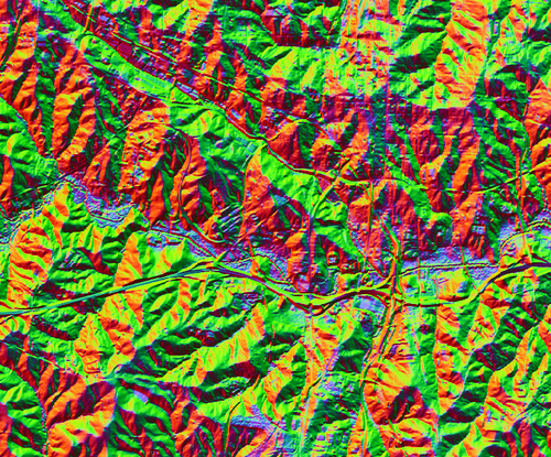
Figure: The RGB composition of first 3 PCA components (output from r.shaded.pca with default values)
SEE ALSO
r.relief, i.pca, r.local.relief, r.skyview
REFERENCES
Devereux, B. J., Amable, G. S., & Crow, P. P. (2008). Visualisation of LiDAR terrain models for archaeological feature detection. Antiquity, 82(316), 470-479.
AUTHOR
Vaclav Petras, NCSU OSGeoREL
SOURCE CODE
Available at: r.shaded.pca source code
(history)
Latest change: Wednesday Mar 11 08:17:30 2026 in commit 2a14bbb