r.patch.smooth
Module for patching rasters with smoothing along edges
r.patch.smooth [-s] input_a=name input_b=name output=name [overlap=name] [blend_mask=string] [smooth_dist=float] [transition_angle=float] [parallel_smoothing=integer] [difference_reach=integer] [--overwrite] [--verbose] [--quiet] [--qq] [--ui]
Example:
r.patch.smooth input_a=name input_b=name output=name smooth_dist=0.0
grass.tools.Tools.r_patch_smooth(input_a, input_b, output, overlap=None, blend_mask=None, smooth_dist=None, transition_angle=None, parallel_smoothing=9, difference_reach=3, flags=None, overwrite=None, verbose=None, quiet=None, superquiet=None)
Example:
tools = Tools()
tools.r_patch_smooth(input_a="name", input_b="name", output="name", smooth_dist=0.0)
This grass.tools API is experimental in version 8.5 and expected to be stable in version 8.6.
grass.script.run_command("r.patch.smooth", input_a, input_b, output, overlap=None, blend_mask=None, smooth_dist=None, transition_angle=None, parallel_smoothing=9, difference_reach=3, flags=None, overwrite=None, verbose=None, quiet=None, superquiet=None)
Example:
gs.run_command("r.patch.smooth", input_a="name", input_b="name", output="name", smooth_dist=0.0)
Parameters
input_a=name [required]
Name for input raster map A
Name of input raster map
input_b=name [required]
Name for input raster map B
Name of input raster map
output=name [required]
Name for output raster map
overlap=name
Name for raster map of spatially variable overlap
Name for output raster map
blend_mask=string
Raster containing edge of raster A which is not to be blended
Useful when raster A has common edge with raster B
smooth_dist=float
Smoothing distance in map units
transition_angle=float
Angle of transition for spatially variable overlap
Recommended values between 1 and 5 degrees
parallel_smoothing=integer
Size of smoothing window for smoothing edges of spatially variable overlap zone
Small value results in more rugged shape of the overlap zone, large values result in spatially non-variable overlap zone. Requires odd values.
Allowed values: 3-99
Default: 9
difference_reach=integer
Look for maximum difference between surfaces in surrounding n cells from the edge
Recommended values between 3 and 9
Allowed values: 2-100
Default: 3
-s
Use spatially variable overlap
--overwrite
Allow output files to overwrite existing files
--help
Print usage summary
--verbose
Verbose module output
--quiet
Quiet module output
--qq
Very quiet module output
--ui
Force launching GUI dialog
input_a : str | np.ndarray, required
Name for input raster map A
Name of input raster map
Used as: input, raster, name
input_b : str | np.ndarray, required
Name for input raster map B
Name of input raster map
Used as: input, raster, name
output : str | type(np.ndarray) | type(np.array) | type(gs.array.array), required
Name for output raster map
Used as: output, raster, name
overlap : str | type(np.ndarray) | type(np.array) | type(gs.array.array), optional
Name for raster map of spatially variable overlap
Name for output raster map
Used as: output, raster, name
blend_mask : str, optional
Raster containing edge of raster A which is not to be blended
Useful when raster A has common edge with raster B
smooth_dist : float, optional
Smoothing distance in map units
transition_angle : float, optional
Angle of transition for spatially variable overlap
Recommended values between 1 and 5 degrees
parallel_smoothing : int, optional
Size of smoothing window for smoothing edges of spatially variable overlap zone
Small value results in more rugged shape of the overlap zone, large values result in spatially non-variable overlap zone. Requires odd values.
Allowed values: 3-99
Default: 9
difference_reach : int, optional
Look for maximum difference between surfaces in surrounding n cells from the edge
Recommended values between 3 and 9
Allowed values: 2-100
Default: 3
flags : str, optional
Allowed values: s
s
Use spatially variable overlap
overwrite : bool, optional
Allow output files to overwrite existing files
Default: None
verbose : bool, optional
Verbose module output
Default: None
quiet : bool, optional
Quiet module output
Default: None
superquiet : bool, optional
Very quiet module output
Default: None
Returns:
result : grass.tools.support.ToolResult | np.ndarray | tuple[np.ndarray] | None
If the tool produces text as standard output, a ToolResult object will be returned. Otherwise, None will be returned. If an array type (e.g., np.ndarray) is used for one of the raster outputs, the result will be an array and will have the shape corresponding to the computational region. If an array type is used for more than one raster output, the result will be a tuple of arrays.
Raises:
grass.tools.ToolError: When the tool ended with an error.
input_a : str, required
Name for input raster map A
Name of input raster map
Used as: input, raster, name
input_b : str, required
Name for input raster map B
Name of input raster map
Used as: input, raster, name
output : str, required
Name for output raster map
Used as: output, raster, name
overlap : str, optional
Name for raster map of spatially variable overlap
Name for output raster map
Used as: output, raster, name
blend_mask : str, optional
Raster containing edge of raster A which is not to be blended
Useful when raster A has common edge with raster B
smooth_dist : float, optional
Smoothing distance in map units
transition_angle : float, optional
Angle of transition for spatially variable overlap
Recommended values between 1 and 5 degrees
parallel_smoothing : int, optional
Size of smoothing window for smoothing edges of spatially variable overlap zone
Small value results in more rugged shape of the overlap zone, large values result in spatially non-variable overlap zone. Requires odd values.
Allowed values: 3-99
Default: 9
difference_reach : int, optional
Look for maximum difference between surfaces in surrounding n cells from the edge
Recommended values between 3 and 9
Allowed values: 2-100
Default: 3
flags : str, optional
Allowed values: s
s
Use spatially variable overlap
overwrite : bool, optional
Allow output files to overwrite existing files
Default: None
verbose : bool, optional
Verbose module output
Default: None
quiet : bool, optional
Quiet module output
Default: None
superquiet : bool, optional
Very quiet module output
Default: None
DESCRIPTION
Module fuses rasters representing elevation together by patching them and smoothing values along edges using either fixed or spatially variable overlap width. Spatially variable overlap width is given by the difference along the edge between the two rasters. Higher difference results in larger overlap width to smooth the transition.
r.patch.smooth can be used, for example, for updating older, lower resolution DEM (input_b) with newer, higher resolution DEM (input_a). Note that both DEMs must be aligned and have the same resolution. Smoothing uses weighted averaging on the overlap of the rasters. r.patch.smooth supports 2 types of smoothing. The default one is simpler and uses fixed overlap width defined in smooth_dist. Since the differences along the seam line can vary, the second option uses spatially variable overlap width and can be activated with flag -s. The width is then computed based on the elevation differences along the edge and transition angle transition_angle controlling the steepness of the transition. If option overlap is specified, a map representing the spatially variable overlap is created and can be used for inspecting the fusion results.
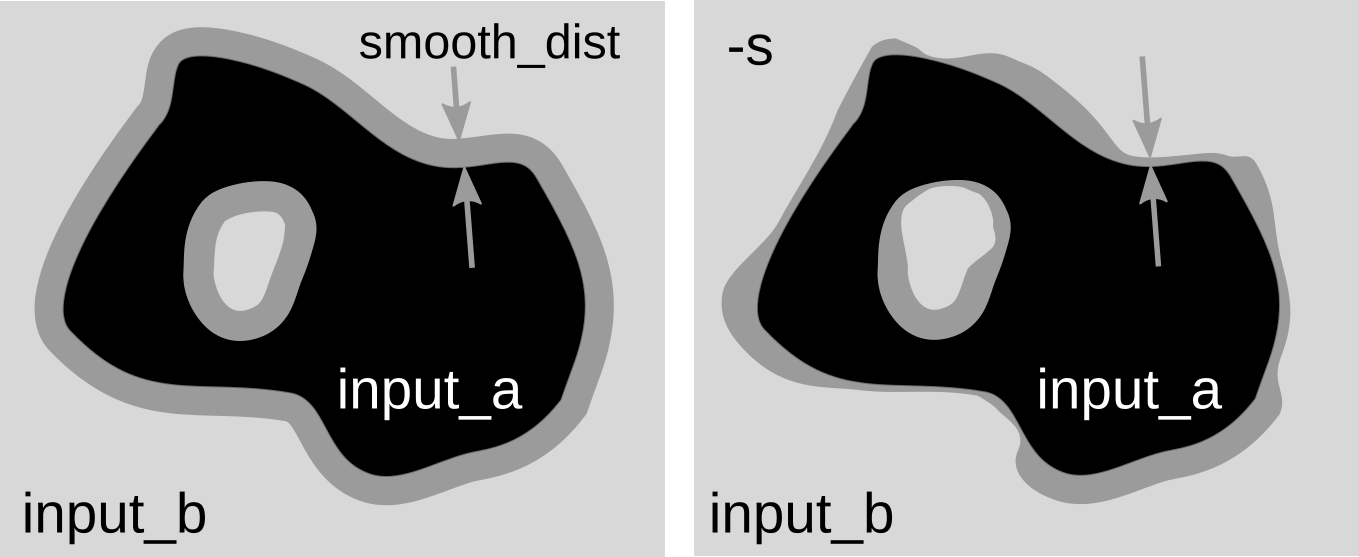
Difference between fixed overlap width and spatially variable overlap.
For spatially variable overlap, options parallel_smoothing and difference_reach can be specified. Option parallel_smoothing smoothes the overlap zone in direction parallel to the edge. Option difference_reach enables to increase the sensitivity to higher differences on the edges by taking maximum difference values in the cells close to edges.
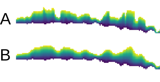
Effect of parallel_smoothing option shown on overlap zone (created
by specifying overlap option). Image A shows result with value 3 and
B with value 9.
Option blend_mask (experimental) can be used to specify which edges of the input_a DEM should be excluded from the blending. This is useful when DEMs A and B have identical edges (on the coast, for example) and we want to preserve only A (not blend it with B along the coast). The blend_mask raster can be created by digitizing area approximately around the excluded edges, so that the edge of DEM A is inside the areas and the rest are NULLs. This option requires more testing.
SEE ALSO
r.patch, r.mapcalc, r.grow.distance
REFERENCES
Anna Petrasova, Helena Mitasova, Vaclav Petras, Justyna Jeziorska. Fusion of high-resolution DEMs for water flow modeling (2017). Open Geospatial Data, Software and Standards. 2: 6. DOI: 10.1186/s40965-017-0019-2
AUTHOR
Anna Petrasova, NCSU GeoForAll Lab
SOURCE CODE
Available at: r.patch.smooth source code
(history)
Latest change: Wednesday Mar 11 08:17:30 2026 in commit 2a14bbb