r.green.hydro.delplants
Delete segments where there is an existing plant
r.green.hydro.delplants [-d] hydro=name [hydro_layer=string] river=name output_streams=string [output_plants=string] [hydro_kind_intake=string] [hydro_kind_turbine=string] elevation=name [other=name] [other_layer=name] [other_kind_intake=string] [other_kind_turbine=string] [--overwrite] [--verbose] [--quiet] [--qq] [--ui]
Example:
r.green.hydro.delplants hydro=name river=name output_streams=string elevation=name
grass.tools.Tools.r_green_hydro_delplants(hydro, hydro_layer="1", river, output_streams, output_plants=None, hydro_kind_intake="intake", hydro_kind_turbine="restitution", elevation, other=None, other_layer="1", other_kind_intake="intake", other_kind_turbine="restitution", flags=None, overwrite=None, verbose=None, quiet=None, superquiet=None)
Example:
tools = Tools()
tools.r_green_hydro_delplants(hydro="name", river="name", output_streams="string", elevation="name")
This grass.tools API is experimental in version 8.5 and expected to be stable in version 8.6.
grass.script.run_command("r.green.hydro.delplants", hydro, hydro_layer="1", river, output_streams, output_plants=None, hydro_kind_intake="intake", hydro_kind_turbine="restitution", elevation, other=None, other_layer="1", other_kind_intake="intake", other_kind_turbine="restitution", flags=None, overwrite=None, verbose=None, quiet=None, superquiet=None)
Example:
gs.run_command("r.green.hydro.delplants", hydro="name", river="name", output_streams="string", elevation="name")
Parameters
hydro=name [required]
Name of the vector map with the points (intake and restitution) of hydropower plants
Or data source for direct OGR access
hydro_layer=string
Name of the vector map layer of the hydropower plants, with the following attributes: kind_label (intake/restitution), discharge [m3/s], id_point, id_plant
Vector features can have category values in different layers. This number determines which layer to use. When used with direct OGR access this is the layer name.
Default: 1
river=name [required]
Name of the vector map with the streams
Or data source for direct OGR access
output_streams=string [required]
Name of the vector map with the stream segments without plants
output_plants=string
Name of the vector map with the stream segments of the existing plants
hydro_kind_intake=string
Value contained in the column kind_label that indicates the plant is an intake
Default: intake
hydro_kind_turbine=string
Value contained in the column kind_label that indicates the plant is a restitution
Default: restitution
elevation=name [required]
Name of input elevation raster map
other=name
Name of the vector map with points (intake and restitution) of other plants such as irrigation, acqueducts, etc.
Or data source for direct OGR access
other_layer=name
Name of the vector map layer of other plants, with the following attributes: kind_label (intake/restitution), discharge [m3/s], id_point, id_plant
Or data source for direct OGR access
Default: 1
other_kind_intake=string
Value contained in the column kind_label that indicates the plant is an intake
Default: intake
other_kind_turbine=string
Value contained in the column kind_label that indicates the plant is a restitution
Default: restitution
-d
Debug with intermediate maps
--overwrite
Allow output files to overwrite existing files
--help
Print usage summary
--verbose
Verbose module output
--quiet
Quiet module output
--qq
Very quiet module output
--ui
Force launching GUI dialog
hydro : str, required
Name of the vector map with the points (intake and restitution) of hydropower plants
Or data source for direct OGR access
Used as: input, vector, name
hydro_layer : str, optional
Name of the vector map layer of the hydropower plants, with the following attributes: kind_label (intake/restitution), discharge [m3/s], id_point, id_plant
Vector features can have category values in different layers. This number determines which layer to use. When used with direct OGR access this is the layer name.
Used as: input, layer
Default: 1
river : str, required
Name of the vector map with the streams
Or data source for direct OGR access
Used as: input, vector, name
output_streams : str, required
Name of the vector map with the stream segments without plants
output_plants : str, optional
Name of the vector map with the stream segments of the existing plants
hydro_kind_intake : str, optional
Value contained in the column kind_label that indicates the plant is an intake
Default: intake
hydro_kind_turbine : str, optional
Value contained in the column kind_label that indicates the plant is a restitution
Default: restitution
elevation : str | np.ndarray, required
Name of input elevation raster map
Used as: input, raster, name
other : str, optional
Name of the vector map with points (intake and restitution) of other plants such as irrigation, acqueducts, etc.
Or data source for direct OGR access
Used as: input, vector, name
other_layer : str, optional
Name of the vector map layer of other plants, with the following attributes: kind_label (intake/restitution), discharge [m3/s], id_point, id_plant
Or data source for direct OGR access
Used as: input, vector, name
Default: 1
other_kind_intake : str, optional
Value contained in the column kind_label that indicates the plant is an intake
Default: intake
other_kind_turbine : str, optional
Value contained in the column kind_label that indicates the plant is a restitution
Default: restitution
flags : str, optional
Allowed values: d
d
Debug with intermediate maps
overwrite : bool, optional
Allow output files to overwrite existing files
Default: None
verbose : bool, optional
Verbose module output
Default: None
quiet : bool, optional
Quiet module output
Default: None
superquiet : bool, optional
Very quiet module output
Default: None
Returns:
result : grass.tools.support.ToolResult | None
If the tool produces text as standard output, a ToolResult object will be returned. Otherwise, None will be returned.
Raises:
grass.tools.ToolError: When the tool ended with an error.
hydro : str, required
Name of the vector map with the points (intake and restitution) of hydropower plants
Or data source for direct OGR access
Used as: input, vector, name
hydro_layer : str, optional
Name of the vector map layer of the hydropower plants, with the following attributes: kind_label (intake/restitution), discharge [m3/s], id_point, id_plant
Vector features can have category values in different layers. This number determines which layer to use. When used with direct OGR access this is the layer name.
Used as: input, layer
Default: 1
river : str, required
Name of the vector map with the streams
Or data source for direct OGR access
Used as: input, vector, name
output_streams : str, required
Name of the vector map with the stream segments without plants
output_plants : str, optional
Name of the vector map with the stream segments of the existing plants
hydro_kind_intake : str, optional
Value contained in the column kind_label that indicates the plant is an intake
Default: intake
hydro_kind_turbine : str, optional
Value contained in the column kind_label that indicates the plant is a restitution
Default: restitution
elevation : str, required
Name of input elevation raster map
Used as: input, raster, name
other : str, optional
Name of the vector map with points (intake and restitution) of other plants such as irrigation, acqueducts, etc.
Or data source for direct OGR access
Used as: input, vector, name
other_layer : str, optional
Name of the vector map layer of other plants, with the following attributes: kind_label (intake/restitution), discharge [m3/s], id_point, id_plant
Or data source for direct OGR access
Used as: input, vector, name
Default: 1
other_kind_intake : str, optional
Value contained in the column kind_label that indicates the plant is an intake
Default: intake
other_kind_turbine : str, optional
Value contained in the column kind_label that indicates the plant is a restitution
Default: restitution
flags : str, optional
Allowed values: d
d
Debug with intermediate maps
overwrite : bool, optional
Allow output files to overwrite existing files
Default: None
verbose : bool, optional
Verbose module output
Default: None
quiet : bool, optional
Quiet module output
Default: None
superquiet : bool, optional
Very quiet module output
Default: None
DESCRIPTION
r.green.hydro.delplants deletes segments of river where there is an existing plant.
NOTES
This command is used to select the segments of river which are not
already exploited by a plant or another structure.
The required inputs are the elevation raster map, the map with the
streams and the one with the intakes and restitution of the existing
plants. In option, it is possible to add the map with the intakes and
restitution of the other structures such aqueducts or irrigation in
order to delete these segments too.
It is necessary to verify in "Optional" that the intakes and restitution
are well reported in the table of the input maps (hydro and other).
EXAMPLE
This example is based on the case-study of Mis valley in Belluno province, Veneto, Italy.
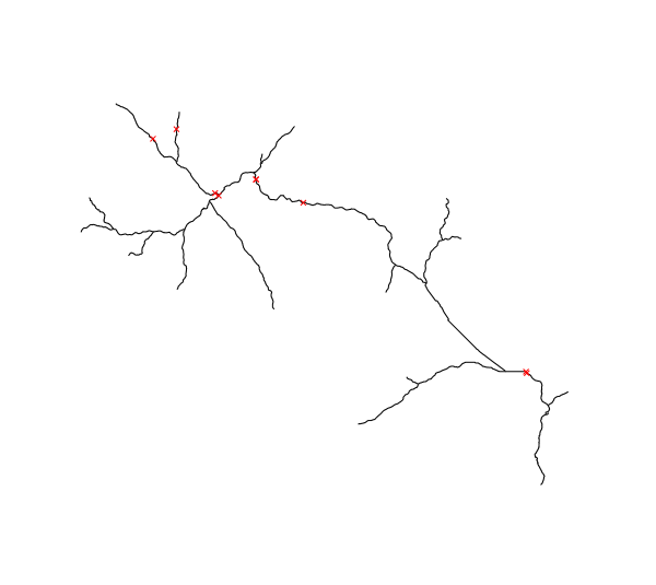
Input vector maps : streams of Mis Valley in black and intakes and
restitution of existing plants in red
We use the following code to compute the available streams and obtain the next map :
r.green.hydro.delplants hydro=existingplants river=streams output=availablestreams elevation=elevation

d.vect map=existingplants color=red
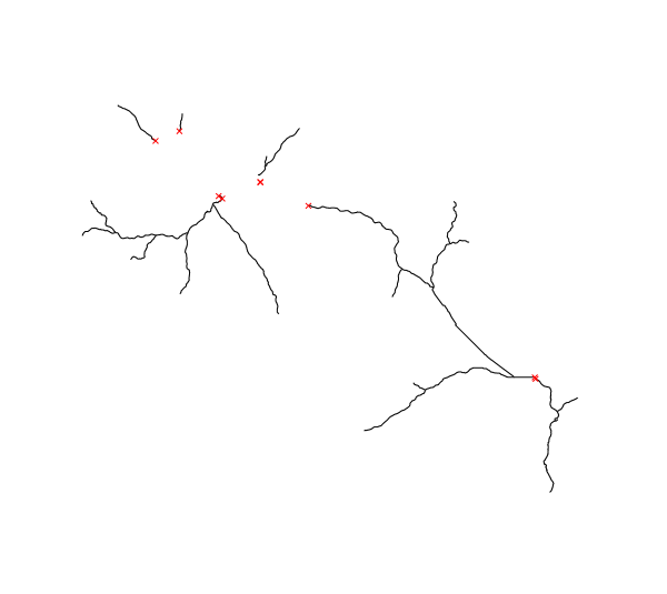
Output vector map in black : streams of Mis Valley without the existing
plants (intakes and restitution of existing plants are added there in
red)
SEE ALSO
r.green.hydro.discharge
r.green.hydro.financial
r.green.hydro.theoretical
r.green.hydro.optimal
r.green.hydro.recommended
r.green.hydro.structure
r.green.hydro.technical
AUTHORS
Giulia Garegnani and Pietro Zambelli (Eurac Research, Bolzano, Italy), Manual written by Julie Gros.
SOURCE CODE
Available at: r.green.hydro.delplants source code
(history)
Latest change: Wednesday Mar 11 08:17:30 2026 in commit 2a14bbb